 W
WFire ecology is a scientific discipline concerned with natural processes involving fire in an ecosystem and the ecological effects, the interactions between fire and the abiotic and biotic components of an ecosystem, and the role as an ecosystem process. Many ecosystems, particularly prairie, savanna, chaparral and coniferous forests, have evolved with fire as an essential contributor to habitat vitality and renewal. Many plant species in fire-affected environments require fire to germinate, establish, or to reproduce. Wildfire suppression not only eliminates these species, but also the animals that depend upon them.
 W
WBiochar is charcoal that is produced by pyrolysis of biomass, yet in the absence of oxygen, and is used as a soil ameliorant for both carbon sequestration and soil health benefits. Biochar is a stable solid that is rich in carbon and can endure in soil for thousands of years. Biochar is being investigated as a means of carbon sequestration, and it may be a means to mitigate global warming and climate change. It results from processes related to pyrogenic carbon capture and storage (PyCCS).
 W
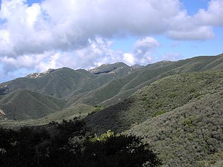
WChaparral is a shrubland or heathland plant community found primarily in the U.S. state of California and in the northern portion of the Baja California Peninsula, Mexico. It is shaped by a Mediterranean climate and wildfire, featuring summer-drought-tolerant plants with hard sclerophyllous evergreen leaves, as contrasted with the associated soft-leaved, drought-deciduous, scrub community of coastal sage scrub, found below the chaparral biome. Chaparral covers 5% of the state of California, and associated Mediterranean shrubland an additional 3.5%. The name comes from the Spanish word for scrub oak, chaparro.
 W
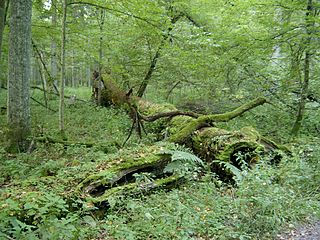
WCoarse woody debris (CWD) or coarse woody habitat (CWH) refers to fallen dead trees and the remains of large branches on the ground in forests and in rivers or wetlands. A dead standing tree – known as a snag – provides many of the same functions as coarse woody debris. The minimum size required for woody debris to be defined as "coarse" varies by author, ranging from 2.5–20 cm (1–8 in) in diameter.
 W
WComplex early seral forests, or snag forests, are ecosystems that occupy potentially forested sites after a stand-replacement disturbance and before re-establishment of a closed forest canopy. They are generated by natural disturbances such as wildfire or insect outbreaks that reset ecological succession processes and follow a pathway that is influenced by biological legacies that were not removed during the initial disturbance. Complex early seral forests develop with rich biodiversity because the remaining biomass provides resources to many life forms and because of habitat heterogeneity provided by the disturbances that generated them. In this and other ways, complex early seral forests differ from simplified early successional forests created by logging. Complex early seral forest habitat is threatened from fire suppression, thinning, and post-fire or post-insect outbreak logging.
 W
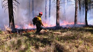
WA controlled or prescribed burn, also known as hazard reduction burning, backfire, swailing, or a burn-off, is a fire set intentionally for purposes of forest management, farming, prairie restoration or greenhouse gas abatement. A controlled burn may also refer to the intentional burning of slash and fuels through burn piles. Fire is a natural part of both forest and grassland ecology and controlled fire can be a tool for foresters.
 W
WCoppicing is a traditional method of woodland management which exploits the capacity of many species of trees to put out new shoots from their stump or roots if cut down. In a coppiced wood, which is called a copse, young tree stems are repeatedly cut down to near ground level, resulting in a stool. New growth emerges, and after a number of years, the coppiced tree is harvested, and the cycle begins anew. Pollarding is a similar process carried out at a higher level on the tree. Daisugi (Dai/sugi) is a similar Japanese technique.
 W
WThe cumulonimbus flammagenitus cloud (CbFg), also known as the pyrocumulonimbus cloud, is a type of cumulonimbus cloud that forms above a source of heat, such as a wildfire or volcanic eruption, and may sometimes even extinguish the fire that formed it. It is the most extreme manifestation of a flammagenitus cloud. According to the American Meteorological Society’s Glossary of Meteorology, a flammagenitus is "a cumulus cloud formed by a rising thermal from a fire, or enhanced by buoyant plume emissions from an industrial combustion process." Analogous to the meteorological distinction between cumulus and cumulonimbus, the CbFg is a fire-aided or –caused convective cloud, like a flammagenitus, but with considerable vertical development. The CbFg reaches the upper troposphere or even lower stratosphere and may involve precipitation, hail, lightning, extreme low-level winds, and in some cases even tornadoes. The combined effects of these phenomena can cause greatly increased fire-spread and cause direct dangers on the ground in addition to 'normal' fires.
 W
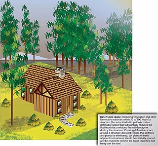
WA defensible space, in the context of fire control, is a natural and/or landscaped area around a structure that has been maintained and designed to reduce fire danger. The practice is sometimes called firescaping. "Defensible space" is also used in the context of wildfires, especially in the wildland-urban interface (WUI). This defensible space reduces the risk that fire will spread from one area to another, or to a structure, and provides firefighters access and a safer area from which to defend a threatened area. Firefighters sometimes do not attempt to protect structures without adequate defensible space, as it is less safe and less likely to succeed.
 W
WA firebreak is a gap in vegetation or other combustible material that acts as a barrier to slow or stop the progress of a bushfire or wildfire. A firebreak may occur naturally where there is a lack of vegetation or "fuel", such as a river, lake or canyon. Firebreaks may also be man-made, and many of these also serve as roads, such as a logging road, four-wheel drive trail, secondary road, or a highway.
 W
WA flammagenitus cloud, also known as a flammagenitus, pyrocumulus cloud or fire cloud, is a dense cumuliform cloud associated with fire or volcanic eruptions that may produce dry lightning.
 W
WA fuel ladder or ladder fuel is a firefighting term for live or dead vegetation that allows a fire to climb up from the landscape or forest floor into the tree canopy. Common ladder fuels include tall grasses, shrubs, and tree branches, both living and dead. The removal of fuel ladders is part of defensible space 'firescaping' practices.
 W
WThe Khun Tan Range is a mountain range that occupies a central position in Northern Thailand. Most of the range is located in Chiang Mai, western Chiang Rai, Lampang and Lamphun Provinces.
 W
WA lignotuber is a woody swelling of the root crown possessed by some plants as a protection against destruction of the plant stem, such as by fire. The crown contains buds from which new stems may sprout, as well as stores of starch that can support a period of growth in the absence of photosynthesis. The term "lignotuber" was coined in 1924 by Australian botanist Leslie R. Kerr.
 W
WThe Phi Pan Nam Range, also Pee Pan Nam, is a 400 km (249 mi) long system of mountain ranges in the eastern half of the Thai highlands. It is mostly in Thailand, although a small section in the northeast is within Sainyabuli and Bokeo Provinces, Laos.
 W
WPre-Columbian savannas of North America, consisting of a mixed woodland-grassland ecosystem, were maintained by both natural lightning fires and by Native Americans before the significant arrival of Europeans. Although decimated by widespread epidemic disease, Native Americans in the 16th century continued using fire to clear savanna until European colonists began colonizing the eastern seaboard. Many colonists continued the practice of burning to clear underbrush, reinforced by their similar experience in Europe, but some land reverted to forest.
 W
WResprouters are plant species that are able to survive fire by the activation of dormant vegetative buds to produce regrowth.
 W
WA sandhill is a type of ecological community or xeric wildfire-maintained ecosystem. It is not the same as a sand dune. It features very short fire return intervals, one to five years. Without fire, sandhills undergo ecological succession and become more oak dominated.
 W
WSmokey Bear is an American campaign and advertising icon of the U.S. Forest Service. In the Wildfire Prevention Campaign, which is the longest-running public service announcement campaign in United States history, the Ad Council, the United States Forest Service (USFS), and the National Association of State Foresters (NASF), in partnership with creative agency FCB, employ Smokey Bear to educate the public about the dangers of unplanned human-caused wildfires. A campaign began in 1944 featuring Smokey and the slogan "Smokey Says – Care Will Prevent 9 out of 10 Forest Fires". His slogan changed to "Remember... Only YOU Can Prevent Forest Fires" in 1947 and was associated with Smokey Bear for more than five decades. In April 2001, the message was officially updated to "Only You Can Prevent Wildfires" in response to a massive outbreak of wildfires in natural areas other than forests, and to clarify that Smokey was promoting the prevention of unplanned outdoor fires, not prescribed burns. Smokey has also had other lines throughout the years, but these have remained his central slogans. According to the Ad Council, 80% of outdoor recreationists correctly identified Smokey Bear's image and 8 in 10 recognized the campaign PSAs.
 W
WPyrogeography is the study of the past, present, and projected distribution of wildfire. Wildland fire occurs under certain conditions of climate, vegetation, topography, and sources of ignition, such that it has its own biogeography, or pattern in space and time. Pyrogeography emerged in the 1990s and 2000s as a combination of biogeography and fire ecology, facilitated by the availability of global-scale datasets of fire occurrence, vegetation cover, and climate. Pyrogeography has also been placed at the juncture of biology, the geophysical environment, and society and cultural influences on fire.
 W
WIn computational science, wildfire modeling is concerned with numerical simulation of wildland fires in order to understand and predict fire behavior. Wildfire modeling can ultimately aid wildland fire suppression, namely increase safety of firefighters and the public, reduce risk, and minimize damage. Wildfire modeling can also aid in protecting ecosystems, watersheds, and air quality.
 W
WWildfire suppression is a range of firefighting tactics used to suppress wildfires. Firefighting efforts in wild land areas require different techniques, equipment, and training from the more familiar structure fire fighting found in populated areas. Working in conjunction with specially designed aerial firefighting aircraft, these wildfire-trained crews suppress flames, construct fire lines, and extinguish flames and areas of heat to protect resources and natural wilderness. Wildfire suppression also addresses the issues of the wildland-urban interface, where populated areas border with wild land areas.