 W
WAtsumi Peninsula is a peninsula in southern Aichi Prefecture, central Honshū, Japan. It has an approximate length of 50 kilometres (31 mi) east-west, separating Mikawa Bay from the Philippine Sea to the south, with Ise Bay lying to its west. It faces the Chita Peninsula, to the northwest, across the entrance to Mikawa Bay. It has a width ranging from 5 kilometres (3.1 mi) to 8 kilometres (5.0 mi), and its highest point is 328 metres (1,076 ft). Its total area is approximately 200 square kilometers.
 W
WThe Bōsō Peninsula is a peninsula that encompasses the entirety of Chiba Prefecture on Honshu, the largest island of Japan. It forms the eastern edge of Tokyo Bay, separating it from the Pacific Ocean. The peninsula covers approximately 5,034 square kilometres (1,944 sq mi).
WChita Peninsula is a peninsula to the south of Aichi Prefecture, central Honshū, Japan. It runs approximately north-south. To the west is Ise Bay, while to the east it encloses Mikawa Bay. It faces the Atsumi Peninsula southeast across Mikawa Bay. Chūbu Centrair International Airport is located off the west coast of the peninsula.
 W
WThe Izu peninsula is a large mountainous peninsula with deeply indented coasts to the west of Tokyo on the Pacific coast of the island of Honshū, Japan. Formerly known as Izu Province, Izu peninsula is now a part of Shizuoka Prefecture. The peninsula has an area of 1,421.24 km2 (548.74 sq mi) and its estimated population in 2005 was 473,942 people. The populated areas primarily lie on the north and east.
 W
WThe Katsuren Peninsula is a peninsula on Okinawa Island. It is bordered by Nakagusuku Bay to the south, Kin Bay to the north, and the Pacific Ocean to the east. The entire peninsula is part of Uruma City. Katsuren Castle is on the south-central part of the peninsula. The Kaichū Dōro is a road connecting the Katsuren Peninsula to Henza Island. Offshore, coral reefs are found.
 W
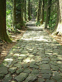
WThe Kii Peninsula is the largest peninsula on the island of Honshū in Japan. It is named after the ancient Kii Province.
 W
WThe Miura Peninsula is a peninsula located in Kanagawa, Japan. It lies south of Yokohama and Tokyo and divides Tokyo Bay, to the east, from Sagami Bay, to the west. Cities and towns on the Miura Peninsula include Yokosuka, Miura, Hayama, Zushi, and Kamakura.
 W
WNatsudomari Peninsula is a peninsula on the northern end of the Japanese island, Honshū, that stretches north into Mutsu Bay. Administratively the area is a part of Aomori Prefecture, and the bulk of the area falls within the jurisdiction of the town of Hiranai, with Aomori city on the western periphery of the landform. The peninsula has several small fishing communities scattered around the coastline, but most of the area's people live in the river valley that demarcates the southern boundary of the peninsula. The peninsula is notably an attractive nesting place for Siberian tundra swan.
 W
WThe Nemuro Peninsula is a peninsula which extends from the east coast of Hokkaidō, Japan. It is some 30 kilometres (19 mi) long and 8 kilometres (5.0 mi) wide, and forms part of Nemuro City. Cape Nosappu at its tip is the easternmost point of Hokkaidō. The northern coastline is on Nemuro Bay, while the south faces the Pacific Ocean. Islands of the Habomai (Khabomai) Archipelago, administered by Russia but claimed by Japan, extend eastward from the peninsula.
 W
WThe Nishisonogi Peninsula is a peninsula in northwest Kyūshū, Japan. It is the north-northwesterly fork of a larger peninsula which also includes Nagasaki and the Nomo Peninsula. To its west is the East China Sea, while to the east it encloses Ōmura Bay.
 W
WThe Noto Peninsula is a peninsula that projects north into the Sea of Japan from the coast of Ishikawa Prefecture in central Honshū, the main island of Japan. The main industries of the peninsula are agriculture, fisheries, and tourism.
 W
WThe Oga Peninsula is a rugged peninsula which projects west into the Sea of Japan from the coast of Akita in northern Honshū, the main island of Japan. Politically it coincides with the city of Oga.
 W
WThe Oshika Peninsula also pronounced "Ojika" is a peninsula which projects southeast into the Pacific Ocean from the coast of Miyagi Prefecture in northeast Honshu, the main island of Japan.
 W
WThe Oshima Peninsula is the southernmost part of Hokkaidō, the northernmost of the Japanese islands. Where the peninsula starts is open to interpretation. A more generous interpretation is to draw a line southeast from Ishikari Bay across the Ishikari Plain to Yūfutsu District, Hokkaido. A narrower interpretation is to draw a line connecting Suttsu on the Sea of Japan and Oshamambe on Uchiura Bay. This narrow interpretation encompasses the subprefectures of Oshima and Hiyama.
 W
WThe Ōsumi Peninsula projects south from the Japanese island of Kyūshū and includes the southernmost point on the island, Cape Sata. Its east coast lies on the Pacific Ocean, while to the west it faces the Satsuma Peninsula across Kagoshima Bay. Politically it is part of Kagoshima Prefecture.
 W
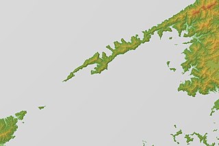
WThe Sadamisaki Peninsula is the westernmost part of the island of Shikoku, and is the narrowest peninsula in Japan. It is covered by the town of Ikata, Ehime Prefecture, and is home to the Ikata Nuclear Power Plant.
 W
WThe Satsuma Peninsula is a peninsula which projects south from the southwest part of Kyūshū Island, Japan. To the west lies the East China Sea, while to the east it faces the Ōsumi Peninsula across Kagoshima Bay. Politically it belongs to Kagoshima Prefecture, and it includes the prefectural capital, Kagoshima City.
 W
WThe Shakotan Peninsula in Shiribeshi, on the west coast of Hokkaidō, Japan, is a mountainous peninsula which projects some 30 kilometres (19 mi) into the Sea of Japan. The Shakotan Peninsula forms part of the Niseko-Shakotan-Otaru Kaigan Quasi-National Park.
 W
WShimabara Peninsula is east of Nagasaki City, Nagasaki Prefecture, Kyūshū, Japan. On its north-eastern tip stands Shimabara City.
 W
WShimokita Peninsula is the remote northeastern cape of the Japanese island of Honshū, stretching out towards Hokkaidō. It is bordered by the Pacific Ocean to the east, Tsugaru Strait to the north and Mutsu Bay to the west and south. Shaped like an axe pointing west, the peninsula has a thin "axe handle" connecting the mountainous "axe blade" to the mainland of Honshū to the south. The peninsula contains the northernmost point on Honshū, Cape Ōma, and the largest sand dunes in Japan.
 W
WShiretoko Peninsula is located on the easternmost portion of the Japanese island of Hokkaidō, protruding into the Sea of Okhotsk. It is separated from Kunashir Island of Russia by the Nemuro Strait. The name Shiretoko is derived from the Ainu word sir etok, meaning "the end of the Earth" or "the place where the Earth protrudes". The towns of Rausu and Shari are found on the peninsula.
 W
WThe Tsugaru Peninsula is a peninsula in Aomori Prefecture, at the northern end of Honshū island, Japan. The peninsula projects north into the Tsugaru Strait separating Honshū from Hokkaidō. The western coast is on the Sea of Japan, while on its eastern coast are Aomori Bay and Mutsu Bay. The peninsula is bisected from Cape Tappi at its northern end to the Hakkōda Mountains on its southern end by the Tsugaru Mountains. Across the Tsugaru strait to the north is Hokkaidō's Matsumae Peninsula, to which it is linked by the Seikan Tunnel.