 W
WThe Acarnanian Mountains is a mountain range in the northwestern part of the Aetolia-Acarnania regional unit in western Greece. It stretches from the village Monastiraki, near Vonitsa, in the north to Astakos in the south, with a total length of nearly 40 km. The Ionian Sea lies to the west.
 W
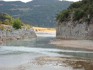
WThe Achelous, also Acheloos, is a river in western Greece. It is 220 km (137 mi) long. It formed the boundary between Acarnania and Aetolia of antiquity. It empties into the Ionian Sea. In ancient times its spirit was venerated as the river god Achelous.
 W
WThe Aitoliko Lagoon is a lagoon located in the south of Aetolia-Acarnania, Greece. It is separated from the larger Missolonghi Lagoon to the south by the island of Aitoliko, but together they form the Missolonghi–Aitoliko Lagoons complex. Its maximum depth is 28 metres. At a salinity of 19-28 PSU, its water is brackish. Oxygen depletion occurs in a large part of the lagoon, but has been reduced since 2002 by creating larger openings around Aitoliko island and dredging channels in Messolongi Lagoon. The main settlement on the lagoon is the town Aitoliko.
 W
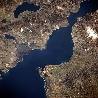
WThe Ambracian Gulf, also known as the Gulf of Arta or the Gulf of Actium, and in some official documents as the Amvrakikos Gulf, is a gulf of the Ionian Sea in northwestern Greece. About 40 km (25 mi) long and 15 km (9 mi) wide, it is one of the largest enclosed gulfs in Greece, and due to its ecological importance is one of the National Parks of Greece. The towns of Preveza, Amphilochia, and Vonitsa lie on its shores.
 W
WThe Evinos is a 92-kilometre-long (57 mi) river in western Greece, flowing into the Gulf of Patras. Its source is in the northern Vardousia mountains, near the village Artotina, Phocis. The river flows in a generally southwestern direction, for most of its length in Aetolia-Acarnania. It feeds the reservoir of Lake Evinos, that is about 10 km². The river flows through a deep forested valley with few small villages. In its lower course it flows through lowlands, and it empties into the Gulf of Patras 10 km southeast of Missolonghi. The village Evinochori near its mouth owes its name to this river.
 W
WThe Gulf of Corinth or the Corinthian Gulf is a deep inlet of the Ionian Sea, separating the Peloponnese from western mainland Greece. It is bounded in the east by the Isthmus of Corinth which includes the shipping-designed Corinth Canal and in the west by the Strait of Rion which widens into the shorter Gulf of Patras and of which the narrowest point is crossed since 2004 by the Rio–Antirrio bridge. The gulf is bordered by the large administrative divisions : Aetolia-Acarnania and Phocis in the north, Boeotia in the northeast, Attica in the east, Corinthia in the southeast and south and Achaea in the southwest. The gulf is in tectonic movement comparable to movement in parts of Iceland and Turkey, growing by 10 mm (0.39 in) per year.
 W
WThe Gulf of Patras is a branch of the Ionian Sea in Western Greece. On the east, it is closed by the Strait of Rion between capes Rio and Antirrio, near the Rio-Antirrio bridge, that is the entrance of the Gulf of Corinth. On the west, it is bounded by a line from Oxeia island to Cape Araxos. To the north it is bounded by the shore of Aetolia-Acarnania in continental Greece, and to the south by Achaea in the Peloponnese peninsula. It is 40–50 km (25–31 mi) long, 10–20 km (6.2–12.4 mi) wide, and has an area of 350–400 km2.
 W
WThe Ionian Sea is an elongated bay of the Mediterranean Sea. It is connected to the Adriatic Sea to the north, and is bounded by Southern Italy, including Calabria, Sicily, and the Salento peninsula to the west, southern Albania to the north, and the west coast of Greece, including the Peloponnese.
 W
WLake Kastraki is an artificial lake near Kastraki in Aetolia-Acarnania, western Greece. The lake is drained by the river Acheloos, and fed by the rivers Acheloos and Inachos. It was formed by the Kastraki Dam, completed in 1969. Its area is about 28 km² and its maximum capacity is 950,000,000 m³ of water. It is used for the generation of hydroelectric power by DEI.
 W
WKlokova is a mountain in the southeast of Aetolia-Acarnania, in western Greece. In classical antiquity, the mountain was known as Taphiassus (Ταφιασσός). Its highest point is 1,039 m.
 W
WLake Kremasta is the largest artificial lake in Greece. The construction of Kremasta Dam was completed in 1965 concentrating waters from four rivers: Acheloos, Agrafiotis, Tavropos and Trikeriotis. The water that is accumulated in the artificial lake is about 3.8 cubic kilometres (3,100,000 acre⋅ft). It prevents flooding of the Acheloos, and supplies electricity to the national grid during peaks of demand. The power station at the dam is the biggest hydroelectric plant in Greece. It was constructed in 1966 and is owned by the Public Power Corporation of Greece. At the time of its construction, it was the largest earth-filled hydroelectric project in Europe.
 W
WLake Amvrakia or Ambracia is a freshwater lake in Aetolia-Acarnania, in western Greece. It lies between the towns of Agrinio and Amphilochia, and is 13.8 kilometres (8.6 mi) long, 3.8 kilometres (2.4 mi) wide and has a maximum depth of 40 metres (130 ft). It is a Natura 2000 protected habitat.
 W
WLysimachia is a lake in Aetolia-Acarnania, western Greece. Its area is 13.2 km², its depth is around 9 m. It is fed by the small river Ermitsa, and by a canal that connects the lake with the larger Lake Trichonida to its east. Its outflow is the river Dimikos, which drains into the river Acheloos. The city of Agrinio lies 6 km to the northeast.
 W
WLake Trichonida is the largest natural lake in Greece. It is situated in the eastern part of Aetolia-Acarnania, southeast of the city of Agrinio and northwest of Nafpaktos. It covers an area of 98.6 square kilometres (38.1 sq mi) with a maximum length of 19 kilometres (12 mi). Its surface elevation is 15 metres (49 ft) and its maximum depth is 58 metres (190 ft).
 W
WThe Megdovas, also known as Tavropos, is a river that flows through the Karditsa and Evrytania regional units, Greece. It is 78 km (48 mi) long.
 W
WThe Missolonghi Lagoon is a shallow lagoon located in the south of Aetolia-Acarnania, Western Greece. It is connected to the Gulf of Patras, a bay of the Ionian Sea. Its length is approximately 15 to 20 km along with its width, its shape resembles a triangle.
 W
WThe Missolonghi-Aitoliko lagoons complex is located in the north part of the Gulf of Patras in the central west coast of Greece. It is one of the most important Mediterranean lagoons. It is a shallow area of 150 km2, extended between the Acheloos and Evinos rivers. It is protected by the Ramsar Convention and it is also included in the Natura 2000 network.
 W
WThe Mornos is a river in Phocis and Aetolia-Acarnania in Greece. It is 70 km (43 mi) long. Its source is in the southwestern part of the Oiti mountains, near the village Mavrolithari, Phocis. It flows towards the south, and enters the Mornos Reservoir near the village Lefkaditi. The dam was completed in 1979. It leaves the reservoir towards the west, near Perivoli. The river continues through a deep, sparsely populated valley, and turns south near Trikorfo. The lower course of the Mornos forms the boundary between Phocis and Aetolia-Acarnania. The Mornos empties into the Gulf of Corinth about 3 km southeast of Nafpaktos.
 W
WLake Ozeros is a lake located west of the Greek city of Agrinio. The lake is formed from the waters of the Acheloos river, flowing from the northwest. The lake has a surface of ca. 10 km2 and an average depth of 8–10 m, but this varies greatly with the season. The road GR-5/E55 runs to the northeastern side.
WPanaitoliko is a mountain range in the northeastern part of Aetolia-Acarnania and southwestern Evrytania, in western Greece. Its highest summit, Kyra Vgena, is the highest point of Aetolia-Acarnania at 1,924 m. Its length is approximately 25 km long from east to west and its width is approximately 15 km wide. The nearest mountains are Kaliakouda to the northeast, the mountains of Nafpaktia to the southeast and Valtou to the northwest. Lake Trichonida lies to the south. The Panaitoliko extends from the Acheloos valley in the northwest to the Evinos valley in the east. There are forests in the lower areas, and grasslands in the higher elevations.
 W
WLake Stratos is an artificial lake near Stratos in Aetolia-Acarnania, western Greece. The lake is fed and drained by the river Acheloos. It was formed by the Stratos Dam, completed in 1989. Its maximum capacity is 80,000,000 m³ of water. Its area is 7.4 km2. It is used for the generation of hydroelectric power.
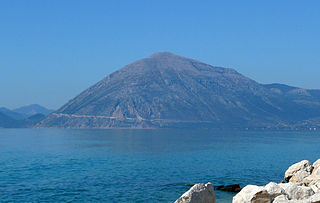
WVarasova is a limestone mountain in the southern part of Aetolia-Acarnania in western Greece. It was known as Chalcis in antiquity, and there was an ancient Aetolian town at its foot named Chalcis, Hypochalcis or Chalceia. It rises steeply from the coast of the Gulf of Patras to 917 m elevation. It is situated just east of the mouth of the river Evinos, 3 km east of Galatas, 14 km east of Missolonghi and 18 km northwest of Patras. 8 km to its east is the mountain Klokova. There are several rock climbing routes on the steep south and southwest faces of the Varasova.