 W
WThe American River is a ~30-mile-long river in California that runs from the Sierra Nevada mountain range to its confluence with the Sacramento River in the Sacramento Valley. Via the Sacramento River, it is part of the San Francisco Bay watershed. This river is fed by the melting snowpack of the Sierra Nevada and its many headwaters and tributaries, including the North Fork American River, the Middle Fork American River, and the South Fork American River.
 W
WThe Middle Fork American River is one of three forks that form the American River in Northern California. It drains a large watershed in the high Sierra Nevada west of Lake Tahoe and northeast of Sacramento in Placer and El Dorado Counties, between the watersheds of the North Fork American River and South Fork American River. The Middle Fork joins with the North Fork near Auburn and they continue downstream to Folsom Lake as the North Fork, even though the Middle Fork carries a larger volume of water.
 W
WThe North Fork American River is the longest branch of the American River in Northern California. It is 88 miles (142 km) long from its source at the crest of the Sierra Nevada, near Lake Tahoe, to its mouth at Folsom Lake northeast of Sacramento. Prior to the construction of Folsom Dam the river was about 9 miles (14 km) longer making for a total length of 97 miles (156 km).
 W
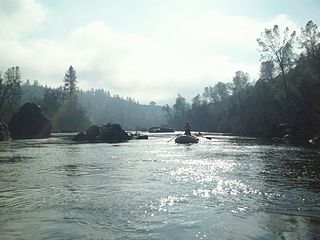
WThe South Fork American River is a major tributary of the American River in El Dorado County, California, draining a watershed on the western slope of the Sierra Nevada east of Sacramento. The river begins in pristine Desolation Wilderness and flows through the Sierra Nevada foothills. The river at Coloma was the site of James Marshall's discovery of gold at Sutter's Mill on January 24, 1848, which started the California Gold Rush. The South Fork of the American is "the most popular recreation stream in the West" for whitewater rafting in North America, e.g., 80,000 visitors in 2011.
 W
WThe Jedediah Smith Memorial Trail is a paved multi-use pathway that runs between the confluence of the Sacramento River with the American River, just north of downtown Sacramento, California, and Beal's Point at Folsom Lake, north of Folsom. The trail is 32 miles (51 km) long, and is used as a major recreational destination, as well as a commuter artery for cyclists. The trail is considered one of the longest paved purpose-built bike trails in the country. The trail is maintained by the County of Sacramento and is painted with mile markers placed at every half-mile increment.
 W
WThe American River Parkway is a 32-mile (51 km) parkway that runs along the American River throughout Sacramento County, California and consists of many smaller parks and boat launching points. It can be accessed by various exits off U.S. Route 50 in Sacramento County.
WAuburn State Recreation Area is a state park unit of California,, along 40 miles (64 km) of the North and Middle Forks of the American River. The state recreation area (SRA) is situated on the border of Placer and El Dorado Counties in the heart of historic Gold Country. The largest city with close proximity is the city of Auburn. Once teeming with gold mining activity, the area now offers a wide variety of outdoor recreational opportunities. Major recreational uses include trail running, hiking, swimming, boating, fishing, camping, mountain biking, gold panning, horseback riding, road bicycling, and off-highway motorcycle riding. Whitewater recreation is also very popular on both forks of the river, with Class II, III and IV runs. Auburn SRA is also known as the location of a number of endurance races that are hosted throughout the year.
WThe American River Parkway is a 32-mile (51 km) parkway that runs along the American River throughout Sacramento County, California and consists of many smaller parks and boat launching points. It can be accessed by various exits off U.S. Route 50 in Sacramento County.
 W
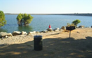
WFolsom Lake is a reservoir on the American River in the Sierra Nevada foothills of California, United States.
 W
WThe Folsom Lake State Recreation Area surrounds Folsom Lake in the foothills of the Sierra Nevada, and is managed by the California Department of Parks and Recreation. It is located near the city of Folsom, California, about 25 miles (40 km) east of Sacramento.
 W
WFolsom Powerhouse State Historic Park is a historical site preserving an 1895 alternating current (AC) hydroelectric power station—one of the first in the United States.
 W
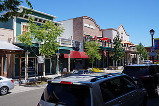
WFolsom is a city in Sacramento County, California, United States. It is commonly known for Folsom Prison, the song "Folsom Prison Blues" as well as for Folsom Lake. The population was 72,203 at the 2010 census. The median home price in Folsom is $624,000 with the average household income at $102,692.
 W
WHell Hole reservoir is an artificial, crescent-shaped lake in the Sierra Nevada mountain range 10 miles (16 km) west of Lake Tahoe in California, United States. The lake is about 3.5 miles (5.6 km) long when at full capacity.
WThe Jedediah Smith Memorial Trail is a paved multi-use pathway that runs between the confluence of the Sacramento River with the American River, just north of downtown Sacramento, California, and Beal's Point at Folsom Lake, north of Folsom. The trail is 32 miles (51 km) long, and is used as a major recreational destination, as well as a commuter artery for cyclists. The trail is considered one of the longest paved purpose-built bike trails in the country. The trail is maintained by the County of Sacramento and is painted with mile markers placed at every half-mile increment.
 W
WLake Clementine is a reservoir on the North Fork American River Canyon above the picturesque, California Gold Rush-era town of Auburn in Northern California. It was created in 1939 when the North Fork Dam, a 155-foot tall variable radius arch dam, was completed by the United States Army Corps of Engineers, for the purpose of containing gold-mining debris which were washing downriver. This resulting reservoir is a long and narrow lake approximately 3.5 miles long and 300 feet wide in some areas. The lake and surrounding area is owned by the United States Bureau of Reclamation and managed by California Department of Parks and Recreation.
 W
WLake Natoma is a small lake in the western United States, along the lower American River, between Folsom and Nimbus Dams in Sacramento County, California. The lake is located within the Folsom Lake State Recreation Area which is responsible for maintaining the facilities and bike trails surrounding the lake. Lake Natoma is located 15 miles east of Sacramento, and has 500 surface acres of water. The total length of lake Natoma is 4 miles.
 W
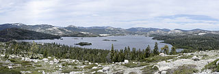
WLoon Lake is a reservoir in the Eldorado National Forest of El Dorado County, California, United States. The 76,200 acre⋅ft (94,000,000 m3) lake is formed by Loon Lake Dam, completed in 1963 as part of the Upper American River Project by Sacramento Municipal Utility District to conserve spring snow melt runoff for use during the summer and autumn for hydroelectric power production. Loon Lake Dam impounds water at the headwaters of Gerle Creek which, prior to the dam, flowed intermittently through (natural) Loon and Pleasant Lakes. But most of the water now stored in Loon Lake arrives from Buck Island Reservoir in the adjacent Rubicon River watershed by way of the Buck-Loon Tunnel. Nearby is Loon Lake Chalet, a popular winter recreation destination. In summer, a boat ramp for water sports and camping are available, but the area is less popular than nearby Union Valley Reservoir and Rubicon Trail.
 W
WMormon Island was once a mining town, which had an abundance of Mormon immigrants seeking gold in the American River during the California Gold Rush. Its site is in present-day Sacramento County, California.
 W
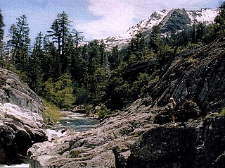
WThe Rubicon River is a major tributary of the Middle Fork American River in the Sierra Nevada of Northern California, west of Lake Tahoe. Its length is 60 miles (97 km) with a watershed of about 184 square miles (477 km2). The river's headwaters are in the Crystal Range of the Sierra Nevada, within the Eldorado National Forest's Desolation Wilderness. Historically, the Rubicon River was known as the South Fork of the Middle Fork of the American River.
WThe South Fork American River is a major tributary of the American River in El Dorado County, California, draining a watershed on the western slope of the Sierra Nevada east of Sacramento. The river begins in pristine Desolation Wilderness and flows through the Sierra Nevada foothills. The river at Coloma was the site of James Marshall's discovery of gold at Sutter's Mill on January 24, 1848, which started the California Gold Rush. The South Fork of the American is "the most popular recreation stream in the West" for whitewater rafting in North America, e.g., 80,000 visitors in 2011.
 W
WUnion Valley Reservoir is a reservoir in eastern El Dorado County, California, about 20 miles (32 km) northeast of Placerville. The 277,000 acre feet (342,000,000 m3) lake is in Eldorado National Forest in the Sierra Nevada at an elevation of 4,870 feet (1,480 m).
 W
WThe Upper American River Project (UARP) is a hydroelectric system operated by the Sacramento Municipal Utility District (SMUD) of Sacramento, California in the United States.