 W
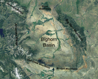
WThe Bighorn Basin is a plateau region and intermontane basin, approximately 100 miles (160 km) wide, in north-central Wyoming in the United States. It is bounded by the Absaroka Range on the west, the Pryor Mountains on the north, the Bighorn Mountains on the east, and the Owl Creek Mountains and Bridger Mountains on the south. It is drained to the north by tributaries of the Bighorn River, which enters the basin from the south, through a gap between the Owl Creek and Bridger Mountains, as the Wind River, and becomes the Bighorn as it enters the basin. The region is semi-arid, receiving only 6–10 in (15–25 cm) of rain annually.
 W
WThe Black Warrior Basin is a geologic sedimentary basin of western Alabama and northern Mississippi in the United States. It is named for the Black Warrior River and is developed for coal and coalbed methane production, as well as for conventional oil and natural gas production. Coalbed methane of the Black Warrior Basin has been developed and in production longer than in any other location in the United States. The coalbed methane is produced from the Pennsylvanian Pottsville Coal Interval.
 W
WThe Delaware Basin is a geologic depositional and structural basin in West Texas and southern New Mexico, famous for holding large oil fields and for a fossilized reef exposed at the surface. Guadalupe Mountains National Park and Carlsbad Caverns National Park protect part of the basin. It is part of the larger Permian Basin, itself contained within the Mid-Continent oil province.
 W
WThe Denver Basin, variously referred to as the Julesburg Basin, Denver-Julesburg Basin, or the D-J Basin, is a geologic structural basin centered in eastern Colorado in the United States, but extending into southeast Wyoming, western Nebraska, and western Kansas. It underlies the Denver-Aurora Metropolitan Area on the eastern side of the Rocky Mountains.
 W
WThe Farmville Basin was one of the Eastern North America Rift Basins. It lies west of Virginia State Route 45 and includes Farmville, Virginia.
 W
WThe Fundy Basin is a sediment-filled rift basin on the Atlantic coast of southeastern Canada. It contains three sub-basins; the Fundy sub-basin, the Minas Basin and the Chignecto Basin. These arms meet at the Bay of Fundy, which is contained within the rift valley. From the Bay of Fundy, the Minas Basin trends northeast to Nova Scotia. Chignecto Bay runs from the Bay of Fundy northwest between New Brunswick and Nova Scotia which is separated from the waters of the Northumberland Strait by the Isthmus of Chignecto. The Fundy Basin is best known for the bay it contains. The Bay of Fundy is home to huge tidal changes and tidal bores. It is part of the system of Eastern North America Rift Basins.
 W
WThe Illinois Basin is a Paleozoic depositional and structural basin in the United States, centered in and underlying most of the state of Illinois, and extending into southwestern Indiana and western Kentucky. The basin is elongate, extending approximately 400 miles northwest-southeast, and 200 miles southwest-northeast.
 W
WThe Jeanne d'Arc Basin is an offshore sedimentary basin located about 340 kilometres to the basin centre, east-southeast of St. John's, Newfoundland and Labrador. This basin formed in response to the large scale plate tectonic forces that ripped apart the super-continent Pangea and also led to sea-floor spreading in the North Atlantic Ocean. This basin is one of a series of rift basins that are located on the broad, shallow promontory of continental crust known as the Grand Banks of Newfoundland off Canada's east coast. The basin was named after a purported 20 metres shoal labelled as "Ste. Jeanne d'Arc" on out-dated bathymetric charts and which was once thought to represent a local exposure of basement rocks similar to the Virgin Rocks.
 W
WThe Los Angeles Basin is a sedimentary basin located in southern California, in a region known as the Peninsular Ranges. The basin is also connected to an anomalous group of east-west trending chains of mountains collectively known as the California Transverse Ranges. The present basin is a coastal lowland area, whose floor is marked by elongate low ridges and groups of hills that is located on the edge of the Pacific Plate. The Los Angeles Basin, along with the Santa Barbara Channel, the Ventura Basin, the San Fernando Valley, and the San Gabriel Basin, lies within the greater southern California region. On the north, northeast, and east, the lowland basin is bound by the Santa Monica Mountains and Puente, Elysian, and Repetto hills. To the southeast, the basin is bordered by the Santa Ana mountains and the San Joaquin Hills. The western boundary of the basin is marked by the Continental Borderland and is part of the onshore portion. The California borderland is characterized by northwest trending offshore ridges and basins. The Los Angeles Basin is notable for its great structural relief and complexity in relation to its geologic youth and small size for its prolific oil production. Yerkes et al. identify five major stages of the basin's evolution, which began in the Upper Cretaceous and ended in the Pleistocene. This basin can be classified as an irregular pull-apart basin accompanied by rotational tectonics during the post-early Miocene.
 W
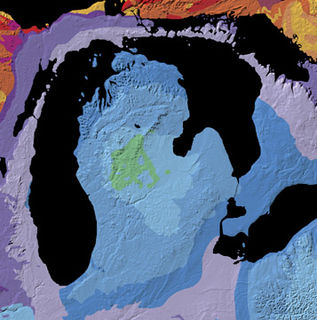
WThe Michigan Basin is a geologic basin centered on the Lower Peninsula of the U.S. state of Michigan. The feature is represented by a nearly circular pattern of geologic sedimentary strata in the area with a nearly uniform structural dip toward the center of the peninsula.
 W
WThe Newark Basin is a sediment-filled rift basin located mainly in northern New Jersey but also stretching into south-eastern Pennsylvania and southern New York. It is part of the system of Eastern North America Rift Basins.
 W
WThe Paradox Basin is an asymmetric foreland basin located mostly in southeast Utah and southwest Colorado, but extending into northeast Arizona and northwest New Mexico. The basin is a large elongate northwest to southeast oriented depression formed during the late Paleozoic Era. The basin is bordered on the east by the tectonically uplifted Uncompahgre Plateau, on the northwest by the San Rafael Swell and on the west by the Circle Cliffs Uplift.
 W
WThe Permian Basin is a large sedimentary basin in the southwestern part of the United States. The basin contains the Mid-Continent Oil Field province. This sedimentary basin is located in western Texas and southeastern New Mexico. It reaches from just south of Lubbock, past Midland and Odessa, south nearly to the Rio Grande River in southern West Central Texas, and extending westward into the southeastern part of New Mexico. It is so named because it has one of the world's thickest deposits of rocks from the Permian geologic period. The greater Permian Basin comprises several component basins; of these, the Midland Basin is the largest, Delaware Basin is the second largest, and Marfa Basin is the smallest. The Permian Basin covers more than 86,000 square miles (220,000 km2), and extends across an area approximately 250 miles (400 km) wide and 300 miles (480 km) long.
 W
WThe Piceance Basin is a geologic structural basin in northwestern Colorado, in the United States. It includes geologic formations from Cambrian to Holocene in age, but the thickest section is made up of rocks from the Cretaceous Period. The basin contains reserves of coal, natural gas, and oil shale. The name likely derives from the Shoshoni word /piasonittsi/ meaning “tall grass”.
 W
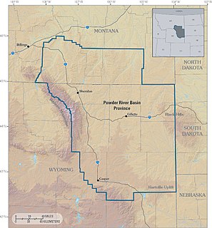
WThe Powder River Basin is a geologic structural basin in southeast Montana and northeast Wyoming, about 120 miles (190 km) east to west and 200 miles (320 km) north to south, known for its coal deposits. The region supplies about 40 percent of coal in the United States. It is both a topographic drainage and geologic structural basin. The basin is so named because it is drained by the Powder River, although it is also drained in part by the Cheyenne River, Tongue River, Bighorn River, Little Missouri River, Platte River, and their tributaries.
 W
WThe Raton Basin is a geologic structural basin in southern Colorado and northern New Mexico. It takes its name from Raton Pass and the town of Raton, New Mexico. In extent, the basin is approximately 50 miles (80 km) east-west, and 90 miles (140 km) north-south, in Huerfano and Las Animas Counties, Colorado, and Colfax County, New Mexico.
 W
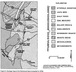
WThe Richmond Basin was one of the Eastern North America Rift Basins. It lies over Swift Creek Reservoir from Interstate 64 to the Appomattox River.
 W
WThe Uinta Basin is a physiographic section of the larger Colorado Plateaus province, which in turn is part of the larger Intermontane Plateaus physiographic division. It is also a geologic structural basin in eastern Utah, east of the Wasatch Mountains and south of the Uinta Mountains. The Uinta Basin is fed by creeks and rivers flowing south from the Uinta Mountains. Many of the principal rivers flow into the Duchesne River which feeds the Green River—a tributary of the Colorado River. The Uinta Mountains forms the northern border of the Uinta Basin. They contain the highest point in Utah, Kings Peak, with a summit 13,528 feet above sea level. The climate of the Uinta Basin is semi-arid, with occasionally severe winter cold.
 W
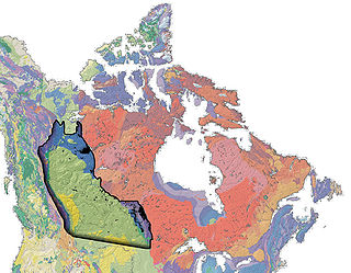
WThe Western Canada Sedimentary Basin (WCSB) is a vast sedimentary basin underlying 1,400,000 square kilometres (540,000 sq mi) of Western Canada including southwestern Manitoba, southern Saskatchewan, Alberta, northeastern British Columbia and the southwest corner of the Northwest Territories. It consists of a massive wedge of sedimentary rock extending from the Rocky Mountains in the west to the Canadian Shield in the east. This wedge is about 6 kilometres (3.7 mi) thick under the Rocky Mountains, but thins to zero at its eastern margins. The WCSB contains one of the world's largest reserves of petroleum and natural gas and supplies much of the North American market, producing more than 16,000,000,000 cubic feet (450,000,000 m3) per day of gas in 2000. It also has huge reserves of coal. Of the provinces and territories within the WCSB, Alberta has most of the oil and gas reserves and almost all of the oil sands.
 W
WThe Williston Basin is a large intracratonic sedimentary basin in eastern Montana, western North Dakota, South Dakota, and southern Saskatchewan, that is known for its rich deposits of petroleum and potash. The basin is a geologic structural basin but not a topographic depression; it is transected by the Missouri River. The oval-shaped depression extends approximately 475 miles (764 km) north-south and 300 miles (480 km) east-west.
 W
WThe Wind River Basin or Shoshone Basin is a semi-arid intermontane foreland basin in central Wyoming, United States. It is bounded by Laramide uplifts on all sides. On the west is the Wind River Range and on the North are the Absaroka Range and the Owl Creek Mountains. The Casper Arch separates the Wind River from the Powder River Basin to the east and the Sweetwater Uplift lies to the south. The basin contains a sequence of 10,000–12,000 feet of predominantly marine sediments deposited during the Paleozoic and Mesozoic Eras. During the Laramide over 18,000 feet of Eocene lacustrine and fluvial sediments were deposited within the basin. Following the Eocene an additional 3,000 feet of sediments were deposited before, and as the basin was uplifted in the late Tertiary.