 W
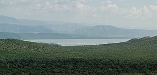
WLake Abaya is a lake in the Southern Nations, Nationalities, and Peoples' Region of Ethiopia. It is located in the Main Ethiopian Rift, east of the Guge Mountains.
 W
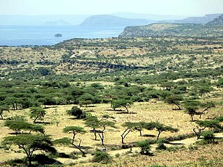
WLake Abbe, also known as Lake Abhe Bad, is a salt lake, lying on the Ethiopia-Djibouti border. It is one of a chain of six connected lakes, which also includes lakes Gargori, Laitali, Gummare, Bario and Afambo. The river Awash flows into the no-drain lake. Lake Abbe is the center of the Afar Depression. Lake Abbe is considered one of the most inaccessible areas of the earth. The water itself is known for its flamingos. The scenery is unique.
 W
WLake Abijatta is an alkaline lake in Ethiopia. It lies in the Main Ethiopian Rift valley south of Addis Ababa, in the Abijatta-Shalla National Park.
 W
WLake Afambo is one of a chain of lakes into which the Awash River empties its waters. It is located at the eastern end of the Afar Region of Ethiopia.
 W
WLake Afrera is a hypersaline lake in northern Ethiopia. Located in Administrative Zone 2 of the Afar Region, it is one of the lakes of the Danakil Depression. According to its entry in Lakenet, it has a surface area of 100 km2 (39 sq mi), although another source states the area is 125 km2 (48 sq mi). An unconfirmed report gives its depth as 160 m (525 ft); the lake is fed by underground streams.
 W
WLake Ardibbo is a freshwater lake of Ethiopia. It is located north of Dessie, in the Debub Wollo Zone of the Amhara Region. It is situated about five kilometers southeast of Lake Hayq; both lakes are in Tehuledere woreda.
 W
WLake Hawassa is an endorheic basin in Sidama Region of Ethiopia, located in the Main Ethiopian Rift south of Addis Ababa. According to the Statistical Abstract of Ethiopia for 1967/68, the lake is 16 km long and 9 km wide, with a surface area of 129 square kilometers. It has a maximum depth of 10 meters and is located at an elevation of 1,708 meters.
WLake Bario is one of a chain of lakes into which the Awash River empties its waters. It is located at the eastern end of the Afar Region of Ethiopia. Lake Bario lies in the middle of a swamp, through which it receives its inflow from Lake Afambo to the northeast. Its outflow is on its southern side, which circles around Mount Dama Ali to empty into Lake Abbe.
 W
WLake Basaka is a shallow, saline lake in the Oromia Region of central Ethiopia. It is located in the Great Rift Valley about 200 kilometres (120 mi) south east of the capital Addis Ababa. The lake is at an elevation of 950 metres (3,000 ft).
 W
WLake Chamo is a lake in the Southern Nations, Nationalities, and Peoples' Region of southern Ethiopia. Located in the Main Ethiopian Rift, it is at an elevation of 1,110 meters. The Chamo lake is just to the south of Lake Abaya and the city of Arba Minch, east of the Guge Mountains, and west of the Amaro Mountains.
 W
WLake Chew Bahir or Lake Istifanos, also called Stefanie, Basso Naebor and Chuwaha, is a lake in southern Ethiopia, located on the southwestern end of the Southern Nations, Nationalities and Peoples' Region, near the border with Oromia Region.
WLake Gummare is one of a chain of lakes into which the Awash River empties its waters. It is located at the eastern end of the Afar Region of Ethiopia.
 W
WLake Hayq or Lake Haik is a freshwater lake of Ethiopia. It is located north of Dessie, in the Debub Wollo Zone of the Amhara Region. The town of Hayq is to the west of the lake.
 W
WLake Hashenge is a lake in the southern Tigray Region of Ethiopia. Located in the Ethiopian highlands at an elevation of 2409 meters, it has no outlet. According to the Statistical Abstract of Ethiopia for 1967/68, Lake Hashenge is five kilometers long and four wide, with a surface area of 20 square kilometers.
 W
WLake Karum is a salt lake in the Afar Region of Ethiopia. One of two salt lakes in the northern end of the Danakil Depression, it lies at −120 m (−394 ft) relative to sea level. The volcano Erta Ale rises southwest of this lake.
 W
WLangano is a lake in the Oromia Region of Ethiopia, exactly 200 kilometers by road south of the capital, Addis Ababa, on the border between the Misraq Shewa and Arsi Zones. The first European to record its existence, Oscar Neumann, records that it was also known as "Lake Kore". It is located to the east of Lake Abijatta in the Main Ethiopian Rift at an elevation of 1,585 meters.
 W
WLake Shala is an alkaline lake located in the Ethiopian Rift Valley, in the Abijatta-Shalla National Park.
 W
WLake Tana is the largest lake in Ethiopia and the source of the Blue Nile. Located in Amhara Region in the north-western Ethiopian Highlands, the lake is approximately 84 kilometres long and 66 kilometres wide, with a maximum depth of 15 metres, and an elevation of 1,788 metres. Lake Tana is fed by the Gilgel Abay, Reb and Gumara rivers. Its surface area ranges from 3,000 to 3,500 square kilometres, depending on season and rainfall. The lake level has been regulated since the construction of the control weir where the lake discharges into the Blue Nile. This controls the flow to the Blue Nile Falls and hydro-power station.
 W
WLake Turkana, formerly known as Lake Rudolf, is a lake in the Kenyan Rift Valley, in northern Kenya, with its far northern end crossing into Ethiopia. It is the world's largest permanent desert lake and the world's largest alkaline lake. By volume it is the world's fourth-largest salt lake after the Caspian Sea, Issyk-Kul, and Lake Van, and among all lakes it ranks 24th.
 W
WZengena Lake is a crater lake located at 10°54′50″N 36°58′00″E in the Awi Zone of the Amhara Region in Ethiopia. It is situated between the towns of Injibara and Kessa, only 200 m from the Addis Ababa-Bahir Dar highway at an elevation of 2500 m. The diameter of the lake is roughly 1 km. With a maximum depth of 166 m, it is the second deepest lake in Ethiopia after Lake Shala. Its rim is made of unconsolidated ash deposits. Zengena Lake is most likely a maar lake formed by volcanic explosion and collapse.
 W
WLake Zway or Lake Ziway is one of the freshwater Rift Valley lakes of Ethiopia. It is located about 100 miles south of Addis Ababa, on the border between the Regions of Oromia Region and of the Southern Nations, Nationalities, and Peoples' Region; the woredas holding the lake's shoreline are Adami Tullu and Jido Kombolcha, Dugda, and Ziway Dugda. The town of Batu lies on the lake's western shore. The lake is fed primarily by two rivers, the Meki from the west and the Katar from the east, and is drained by the Bulbar which empties into Lake Abijatta. The lake's catchment has an area of 7025 square kilometers.