 W
WKing Island is an island in the Bass Strait, belonging to the Australian state of Tasmania. It is the largest of three islands known as the New Year Group, and the second-largest island in Bass Strait. The island's population at the 2016 census was 1,585 people, up from 1,566 in 2011. The local government area of the island is the King Island Council.
 W
WCape Wickham is the most northerly point of King Island, Tasmania, Australia. From here, it is 90 kilometres (56 mi) to Cape Otway on the Australian mainland. In the 19th century, ships coming from Europe would sometimes attempt to sail between Cape Wickham and Cape Otway to cut down on the required travelling time to Sydney, however the trip was dangerous and the price of failure high; usually shipwreck on the unforgiving King Island coast.
 W
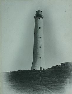
WThe Cape Wickham Lighthouse is a lighthouse situated at Cape Wickham on King Island, Tasmania. At 48 metres (157 ft) tall, it is Australia's tallest lighthouse. The lighthouse is listed on the Commonwealth Heritage Register.
 W
WCataraqui was a British barque which sank off the south-west coast of King Island in Bass Strait on 4 August 1845. The sinking was Australia's worst ever maritime civil disaster incident, claiming the lives of 400 people.
WThe Christmas Island, part of the New Year Group, is a 63.49-hectare (156.9-acre) granite island located in the Great Australian Bight, lying off the north-west coast of Tasmania, Australia. According to the International Hydrographic Organization, the line separating Bass Strait from the Great Australian Bight runs through King Island, so Christmas Island lies in the Great Australian Bight.
WThe Councillor Island, part of the New Year Group, is a 10.53-hectare (26.0-acre) granite island located in the Bass Strait, lying off the north-west coast of Tasmania, Australia.
 W
WCurrie is the largest township on, and is the administrative centre of, King Island, Tasmania, at the western entrance to Bass Strait. At the 2006 census, Currie had a population of 746.
 W
WThe King Island emu is an extinct subspecies of emu that was endemic to King Island, in the Bass Strait between mainland Australia and Tasmania. Its closest relative may be the extinct Tasmanian emu, as they belonged to a single population until less than 14,000 years ago when Tasmania and King Island were still connected. The small size of the King Island emu may be an example of insular dwarfism. The King Island emu was the smallest of all known emus and had darker plumage than the mainland emu. It was black and brown and had naked blue skin on the neck, and its chicks were striped like those on the mainland. The subspecies was distinct from the likewise diminutive Kangaroo Island emu in a number of osteological details, including size. The behaviour of the King Island emu probably did not differ much from that of the mainland emu. The birds gathered in flocks to forage and during breeding time. They fed on berries, grass and seaweed. They ran swiftly and could defend themselves by kicking. The nest was shallow and consisted of dead leaves and moss. Seven to nine eggs were laid, which were incubated by both parents.
 W
WGrassy is a township on King Island, Tasmania, Australia. It was a tungsten mining town. Evidence of this can still be found in the small town. The highest population of Grassy was 767, in 1971. At the 2006 census, it had a population of 219.
 W
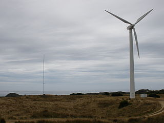
WHuxley Hill Wind Farm is a wind power station at King Island, Tasmania, Australia, of around 1600 residents, owned by Hydro Tasmania, which supplements the four diesel generators with a combined capacity of 6 MW at Currie Power Station. King Island also has a 100 kW solar capacity provided with monocrystaline solar panels on dual-axis arrays.
 W
WKing is an interim Australian bioregion located on King Island in Tasmania, Australia comprising 425,567 hectares.
WKing Island Airport is a small regional airport located near the town of Currie on King Island off the north-west coast of Tasmania, Australia. The airport is owned and operated by the King Island Council.
WLake Flannigan is a natural freshwater lake on King Island, Tasmania, Australia, situated four kilometres south of the Cape Wickham Lighthouse, in the northern locality of Wickham.
 W
WLavinia State Reserve, formerly Lavinia Nature Reserve, is a 68 km2 protected area on King Island, lying at the western end of Bass Strait and belonging to the Australian state of Tasmania.
WLymwood is a rural locality in the local government area of King Island on King Island in Bass Strait, north of Tasmania. It is located about 27 kilometres (17 mi) south-east of the town of Currie, the administrative centre for the island. The 2016 census determined a population of 114 for the state suburb of Lymwood.
WNaracoopa is a rural locality and village in the local government area of King Island on King Island in Bass Strait, north of Tasmania. It is located about 26 kilometres (16 mi) east of the town of Currie, the administrative centre for the island. The 2016 census determined a population of 62 for the state suburb of Naracoopa.
WThe New Year Island, part of the New Year Group, is a 98.22-hectare (242.7-acre) granite island and game reserve located in the Great Australian Bight, lying off the north-west coast of Tasmania, Australia. While much smaller in area than the adjacent King Island, the New Year Island lends its name to the island group due to its European discovery a few days earlier than the King Island.
WPegarah is a rural locality in the local government area of King Island on King Island in Bass Strait, north of Tasmania. It is located about 24 kilometres (15 mi) east of the town of Currie, the administrative centre for the island. The 2016 census determined a population of 134 for the state suburb of Pegarah.
 W
WSouthern Cross was a three-masted schooner originally built in 1891 for the Melanesian Mission of the Anglican Church and the Church of the Province of Melanesia, and was lost with all hands off King Island, Tasmania in 1920.
WWickham is a rural locality in the local government area of King Island on King Island in Bass Strait, north of Tasmania. It is located about 41 kilometres (25 mi) north of the town of Currie, the administrative centre for the island. The 2016 census determined a population of 9 for the state suburb of Wickham.
WYarra Creek is a rural locality in the local government area of King Island on King Island in Bass Strait, north of Tasmania. It is located about 31 kilometres (19 mi) south-east of the town of Currie, the administrative centre for the island. The 2016 census determined a population of 36 for the state suburb of Yarra Creek.