 W
WAngaur or Ngeaur is an island in the island nation of Palau. The island, which forms its own state, has an area of 8 km² (3 mi²). Its population was 130 in 2012. The state capital is the village of Ngeremasch on the western side. A second village, Rois, is immediately east of Ngeremasch.
 W
WBabeldaob is the largest island in the island nation of the Republic of Palau. It is in the western Caroline Islands, and the second largest island in the Micronesia region of Oceania. Palau's capital, Ngerulmud, is located on Babeldaob, in Melekeok State.
 W
WBablomekang is an island in the Rock Islands of Palau. It was last inhabited 2004, when inhabitants decided to move due to floodings.
WChomedokl is an island of Palau. It is most known for its north cave entrance, which is a World Heritage Site listed by UNESCO.
WChouwid is an island of Palau.
 W
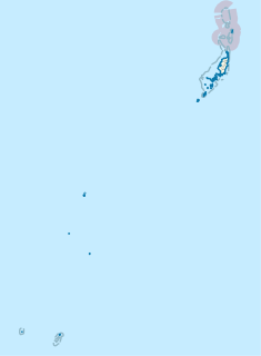
WTobi, or Hatohobei (Tobian), also ハトホベイ州 (Japanese), is the southernmost of Palau's sixteen states, consisting of Tobi Island and Helen Reef. The total land area is about 0.88 km². The population was 80 in 1962, 51 in 1995, 23 in 2000, and 25 in 2015. Tobian, English and Sonsorolese are the official languages of Hatohobei State.
 W
WKayangel is the northernmost state of Palau 24 km (15 mi) north of Koror. The land area is about 1.4 km2 (0.54 sq mi). The population is 54.
 W
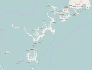
WKoror is the state comprising the main commercial centre of the Republic of Palau. It consists of several islands, the most prominent being Koror Island.
WKuabeserrai is an island of Palau.
WMalakal Island is an island in the state of Koror, Palau. It is located at 134.45, 7.330278.
 W
WMerir or Melieli is a small outlying island of the Palau group, in the western Pacific Ocean. The island measures 0.90 km² and is uninhabited. There is an abandoned village in the north-west of the island which previously hosted a radio station.
WNgeanges is an island of Palau.
WNgelsibel is an island of Palau.
 W
WNgerukewid or Ngerukeuid is a set of islands located inside the Palau's lagoon. The set contains 37 small raised coral islands, which range in size from 0.1 to 48.5 ha, and amount to total land area of 87.3 ha. The islands and the area around them are protected under the Ngerukewid Islands Wildlife Preserve, which was established in 1956.
WNgkesill is an island geographically located at 7.3383°N 134.5550°E of Palau.
WOilouch is an island in the Rock Islands of Palau.
WOngetkatel is a channel of water and island of Palau, administrated by the State of Koror.
 W
WPeleliu is an island in the island nation of Palau. Peleliu, along with two small islands to its northeast, forms one of the sixteen states of Palau. The island is notable as the location of the Battle of Peleliu in World War II.
 W
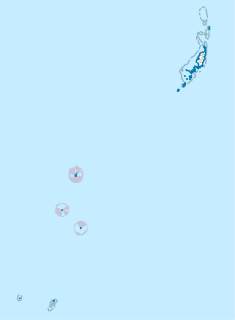
WSonsorol is one of the sixteen states of Palau. The administrative center, and only village, is Dongosaru on Sonsorol island. The inhabitants speak Sonsorolese, a local Trukic language, and Palauan.
 W
WTobi is an island in the Palauan state of Hatohobei. With a population of about 30, it holds all of the state's people, with the exception of a weather base on another island. Most of the inhabitants live on the island's west side and speak Tobian. Tobi, Helen Reef (Hotsarihie), Transit Reef (Pieraurou), and the islands in the state of Sonsorol make up The Republic of Palau's Southwest Islands. Tobi Island is 1.6 km long and 0.8 km wide, and has an area of about 0.85 square kilometres (0.33 sq mi).
 W
WUlong is a major island and channel of western Palau. It is sometimes called Aulong and originally written Oroolong in English. Ulong is regarded by many as one of the best drift dives in the world.