 W
WAn erg is a broad, flat area of desert covered with wind-swept sand with little or no vegetative cover. The term takes its name from the Arabic word ʿarq (عرق), meaning "dune field". Strictly speaking, an erg is defined as a desert area that contains more than 125 km2 (48 sq mi) of aeolian or wind-blown sand and where sand covers more than 20% of the surface. Smaller areas are known as "dune fields". The largest hot desert in the world, the Sahara, covers 9 million square kilometres and contains several ergs, such as the Chech Erg and the Issaouane Erg in Algeria. Approximately 85% of all the Earth's mobile sand is found in ergs that are greater than 32,000 km2 (12,355 sq mi). Ergs are also found on other celestial bodies, such as Venus, Mars, and Saturn's moon Titan.
 W
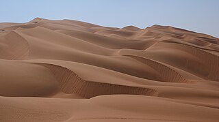
WIn geomorphology, an erg is a large desert region of sand dunes with little or no vegetation, especially in the Sahara. This is a list of ergs around the world.
 W
WAd-Dahna Desert is the central division of the Arabian Desert. It is a corridor of sandy terrain forming a bow-like shape that connects an-Nafud desert in the north to Rub' al-Khali desert in the south. Its length is more than 1,000 km (620 mi) siding Twaik Mountains from the east and does not exceed 80 km (50 mi) in width. It is also considered the geographical margin separating Al-Ahsa Province from Najd. Al-Dahna Desert is therefore the string that connects the great deserts of Saudi Arabia.
 W
WThe Algodones Dunes is a large erg located in the southeastern portion of the U.S. state of California, near the border with Arizona and the Mexican state of Baja California. The field is approximately 45 miles (72 km) long by 6 miles (9.7 km) wide and extends along a northwest-southeast line that correlates to the prevailing northerly and westerly wind directions. The name "Algodones Dunes" refers to the entire geographic feature, while the administrative designation for that portion managed by the Bureau of Land Management is the Imperial Sand Dunes Recreation Area. In 1966, Imperial Sand Hills was designated as a National Natural Landmark by the National Park Service. The Algodones Dunes are split into many different sections. These sections include Glamis, Gordon's Well, Buttercup, Midway, and Patton's Valley. Although the Arabic-derived Spanish word algodones translates to "cotton plants", the origin of the toponym is unknown.
 W
WThe Atacama Desert is a desert plateau in South America covering a 1,600 km (990 mi) strip of land on the Pacific coast, west of the Andes Mountains. The Atacama Desert is the driest nonpolar desert in the world, as well as the only true desert to receive less precipitation than the polar deserts and the largest fog desert in the world. Both regions have been used as experimentation sites on Earth for Mars expedition simulations. According to estimates, the Atacama Desert occupies 105,000 km2 (41,000 sq mi), or 128,000 km2 (49,000 sq mi) if the barren lower slopes of the Andes are included. Most of the desert is composed of stony terrain, salt lakes (salares), sand, and felsic lava that flows towards the Andes.
 W
WThe Lut Desert, widely referred to as Dasht-e Lut, is a large salt desert located in the provinces of Kerman and Sistan and Baluchestan, Iran. It is the world's 25th-largest desert, and was included on UNESCO's World Heritage List on July 17, 2016. The surface of its sand has been measured at temperatures as high as 70 °C (159 °F), making it one of the world's driest and hottest places.
 W
WThe Gibson Desert is a large desert in Western Australia. and is still largely in an almost "pristine" state. It is about 155,000 square kilometres (60,000 sq mi) in size, making it the fifth largest desert in Australia, after the Great Victoria, Great Sandy, Tanami and Simpson deserts. The Gibson Desert is both an interim Australian bioregion and desert ecoregion.
 W
WThe Gran Desierto de Altar is one of the major sub-ecoregions of the Sonoran Desert, located in the State of Sonora, in northwest Mexico. It includes the only active erg dune region in North America. The desert extends across much of the northern border of the Gulf of California, spanning more than 100 kilometres (62 mi) east to west and over 50 kilometres (31 mi) north to south. It constitutes the largest continuous wilderness area within the Sonoran Desert.
 W
WThe Great Sandy Desert (GSD) is an interim Australian bioregion, located in the north west of Western Australia straddling the Pilbara and southern Kimberley regions. It is the second largest desert in Australia after the Great Victoria Desert and encompasses an area of 284,993 square kilometres (110,036 sq mi). The Gibson Desert lies to the south and the Tanami Desert lies to the east of the Great Sandy Desert.
 W
WThe Great Victoria Desert is a sparsely-populated desert ecoregion and interim Australian bioregion in Western Australia and South Australia.
 W
WThe Karakum Desert, also spelled Kara-Kum and Gara-Gum, is a desert in Central Asia. Its second word means sand; its first is a contraction of garaňky: "dark" or may pre-date that in this language family. This refers to the shale-rich sand generally beneath the sand of much of the desert. It occupies about 70 percent, 350,000 km², of Turkmenistan.
 W
WThe Kyzylkum Desert is the 15th largest desert in the world. Its name means Red Sand in Turkic languages. It is located in Central Asia in the doab between the rivers Amu Darya and Syr Darya, a region historically known as Transoxania or Sogdiana. Today it is divided between Kazakhstan, Turkmenistan and Uzbekistan. It covers about 298,000 km2 (115,000 sq mi).
 W
WThe Mu Us Desert is a desert in northern China. It is crossed by the Great Wall of China at the south-eastern end of the desert. The Mu Us Desert forms the southern portion of the Ordos Desert and part of the Ordos Loop. The Wuding River drains the area, and then flows into the Yellow River.
 W
WThe Navajo Sandstone is a geological formation in the Glen Canyon Group that is spread across the U.S. states of southern Nevada, northern Arizona, northwest Colorado, and Utah as part of the Colorado Plateau province of the United States.
 W
WThe Ordos Desert is a desert/steppe region in Northwest China, administrated under the prefecture of Ordos City in the Inner Mongolian Autonomous Region. It extends over an area of approximately 90,650 km2 (35,000 sq mi), and comprises two sub-deserts: China's 7th largest desert, the Kubuqi Desert, in the north; and China's 8th largest desert, the Mu Us Desert, in the south. Wedged between the arable Hetao region to the north and the Loess Plateau to the south, the soil of the Ordos Desert is mostly a mixture of dry clay and sand, and as a result is poorly suited for agriculture.
 W
WThe Rub' al Khali is the sand desert (erg) encompassing most of the southern third of the Arabian Peninsula. The desert covers some 650,000 km2 (250,000 sq mi) including parts of Saudi Arabia, Oman, the United Arab Emirates, and Yemen. It is part of the larger Arabian Desert.
 W
WSand dunes are common features of shoreline and desert environments. Dunes provide habitat for highly specialized plants and animals, including rare and endangered species. They can protect beaches from erosion and recruit sand to eroded beaches. Dunes are threatened by human activity, both intentional and unintentional. Countries such as the United States, Australia, Canada, New Zealand, the United Kingdom, and Netherlands, operate significant dune protection programs.
 W
WThe Simpson Desert is a large area of dry, red sandy plain and dunes in Northern Territory, South Australia and Queensland in central Australia. It is the fourth-largest Australian desert, with an area of 176,500 km2 (68,100 sq mi).
 W
WThe Taklamakan Desert is a desert in Southwest Xinjiang in Northwest China. It is bounded by the Kunlun Mountains to the south, the Pamir Mountains and Tian Shan to the west and north and the Gobi Desert to the east.
 W
WThe Tengger Desert is an arid natural region that covers about 36,700 km2 and is mostly in the Inner Mongolia Autonomous Region in China.
 W
WThe Thar Desert, also known as the Great Indian Desert, is a large arid region in the northwestern part of the Indian subcontinent that covers an area of 200,000 km2 (77,000 sq mi) and forms a natural boundary between India and Pakistan. It is the world's 17th largest desert, and the world's 9th largest hot subtropical desert.