 W
WIn physical geography, tundra is a type of biome where the tree growth is hindered by low temperatures and short growing seasons. The term tundra comes through Russian тундра from the Kildin Sámi word тӯндар meaning "uplands", "treeless mountain tract". Tundra vegetation is composed of dwarf shrubs, sedges and grasses, mosses, and lichens. Scattered trees grow in some tundra regions. The ecotone between the tundra and the forest is known as the tree line or timberline. The tundra soil is rich in nitrogen and phosphorus.
 W
WAlpine tundra is a type of natural region or biome that does not contain trees because it is at high elevation. As the latitude of a location approaches the poles, the threshold elevation for alpine tundra gets lower until it reaches sea level, and alpine tundra merges with polar tundra.
 W
WThe Antarctic Peninsula, known as O'Higgins Land in Chile and Tierra de San Martin in Argentina, and originally as the Palmer Peninsula in the US and Graham Land in the United Kingdom, is the northernmost part of the mainland of Antarctica.
 W
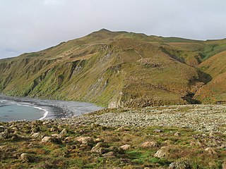
WThe Antipodes Subantarctic Islands tundra ecoregion, within the tundra biome, includes five remote island groups in the Pacific Ocean south of New Zealand: the Bounty Islands, Auckland Islands, Antipodes Islands and Campbell Island groups of New Zealand, and Macquarie Island of Australia.
 W
WThe Beatrice Willard Alpine Tundra Research Plots were established in 1959 along Trail Ridge Road in Rocky Mountain National Park, Colorado, above the treeline in an alpine tundra habitat. The plots were used by Beatrice Willard of the Institute of Arctic and Alpine Research at the University of Colorado from 1959 to about 1999 in a long-term study of the alpine ecosystem. Willard's dissertation and updates, as well as her book Land Above the Trees: A Guide to American Alpine Tundra were highly influential in studies of alpine and tundra ecology. Her recommendations were used by the National Park Service in its management of the high alpine areas of the park. Willard's work continued after she moved on to other work, and for the last twenty years she made informal visits to the plots.
 W
WThe Canadian Arctic tundra is a biogeographic designation for Northern Canada's terrain generally lying north of the tree line or boreal forest, that corresponds with the Scandinavian Alpine tundra to the east and the Siberian Arctic tundra to the west inside the circumpolar tundra belt of the Northern Hemisphere.
WIn physical geography, tundra is a type of biome where the tree growth is hindered by low temperatures and short growing seasons. The term tundra comes through Russian тундра from the Kildin Sámi word тӯндар meaning "uplands", "treeless mountain tract". Tundra vegetation is composed of dwarf shrubs, sedges and grasses, mosses, and lichens. Scattered trees grow in some tundra regions. The ecotone between the tundra and the forest is known as the tree line or timberline. The tundra soil is rich in nitrogen and phosphorus.
 W
WEast Antarctica, also called Greater Antarctica, constitutes the majority (two-thirds) of the Antarctic continent, lying on the Indian Ocean side of the continent, separated from West Antarctica by the Transantarctic Mountains. It lies almost entirely within the Eastern Hemisphere and its name has been accepted for more than a century. It is generally higher than West Antarctica and includes the Gamburtsev Mountain Range in the centre.
 W
WArctic ecology is the scientific study of the relationships between biotic and abiotic factors in the arctic, the region north of the Arctic Circle. This region is characterized by stressful conditions as a result of extreme cold, low precipitation, a limited growing season and virtually no sunlight throughout the winter. The Arctic consists of taiga and tundra biomes, which also dominate very high elevations, even in the tropics. Sensitive ecosystems exist throughout the Arctic region, which are being impacted dramatically by global warming. The earliest inhabitants of the Arctic were the Neanderthal sub-species. Since then, many indigenous populations have inhabited the region, which continues to this day. Since the early 1900s, when Vilhjalmur Stefansson led the first major Canadian Arctic Expedition, the Arctic has been a valued area for ecological research. In 1946, The Arctic Research Laboratory was established in Point Barrow, Alaska under the contract of the Office of Naval Research. This launched an interest in exploring the Arctic examining animal cycles, permafrost and the interactions between indigenous peoples and the Arctic ecology. During the Cold War, the Arctic became a place where the United States, Canada, and the Soviet Union performed significant research that has been essential to the study of climate change in recent years. A major reason why research in the Arctic is essential for the study of climate change is because the effects of climate change will be felt more quickly and more drastically in higher latitudes of the world as above average temperatures are predicted for Northwest Canada and Alaska. From an anthropological point of view, researchers study the native Inuit peoples of Alaska as they have become extremely accustomed to adapting to ecological and climate variability.
 W
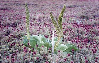
WFeldmark, also spelt fjaeldmark, is a plant community characteristic of sites where plant growth is severely restricted by extremes of cold and exposure to wind, typical of alpine tundra and subantarctic environments.
 W
WFinnmark, Winter is a painting by Norwegian artist Anna-Eva Bergman in 1966. The picture was made with metal foil on canvas and has dimensions of 150 x 300 cm.
 W
WThe High Alps are those parts of the Alps unsuitable for habitation or seasonal transhumance. This includes all regions higher than 3,000 m above sea level, as well as most regions between 2,500 m and 3,000 m.
 W
WThe Interior Yukon-Alaska alpine tundra ecoregion covers alpine, sub-alpine, and boreal forest areas along the cordillera of Interior Alaska and south-central Yukon Territory. Geologically, they are the disjunct uplands of the Yukon-Tanana Terrane plus a southern extension of the Brooks Range. The cover is extensive 'dark taiga' of closed spruce forest, open forest of other species, and alpine vegetation at higher altitudes. The region is mostly wilderness and relatively untouched by human development.
 W
WThe Kerguelen Islands, also known as the Desolation Islands, are a group of islands in the Antarctic constituting one of the two exposed parts of the Kerguelen Plateau, a large igneous province mostly submerged by the southern Indian Ocean. They are among the most isolated places on Earth, located more than 3,300 km (2,100 mi) from Madagascar, the nearest permanently populated location; Heard Island is 450 km (280 mi) to the south-east. The islands, along with Adélie Land, the Crozet Islands, Amsterdam and Saint Paul Islands, and France's Scattered Islands in the Indian Ocean, are part of the French Southern and Antarctic Lands and are administered as a separate district.
 W
WThe North American Arctic is composed of the northern portions of Alaska (USA), Northern Canada and Greenland. Major bodies of water include the Arctic Ocean, Hudson Bay, the Gulf of Alaska and North Atlantic Ocean. The North American Arctic lies above the Arctic Circle. It is part of the Arctic, which is the northernmost region on Earth. The western limit is the Seward Peninsula and the Bering Strait. The southern limit is the Arctic Circle latitude of 66° 33’N, which is the approximate limit of the midnight sun and the polar night.
 W
WThe Scotia Sea is a sea located at the northern edge of the Southern Ocean at its boundary with the South Atlantic Ocean. It is bounded on the west by the Drake Passage and on the north, east, and south by the Scotia Arc, an undersea ridge and island arc system supporting various islands. The sea sits atop the Scotia Plate. It is named after the expedition ship Scotia. Many icebergs melt there.
 W
WThe Southern Indian Ocean Islands tundra is a tundra ecoregion that includes several subantarctic islands in the southern Indian Ocean.
 W
WDuring the Last Glacial Maximum, the mammoth steppe was the Earth’s most extensive biome. It spanned from Spain eastward across Eurasia to Canada and from the arctic islands southward to China. It had a cold, dry climate; the vegetation was dominated by palatable high-productivity grasses, herbs and willow shrubs, and the animal biomass was dominated by bison, horses, and woolly mammoth. This ecosystem covered wide areas of the northern part of the globe, thrived for approximately 100,000 years without major changes, and then suddenly became all but extinct about 12,000 years ago.
WWest Antarctica, or Lesser Antarctica, one of the two major regions of Antarctica, is the part of that continent that lies within the Western Hemisphere, and includes the Antarctic Peninsula. It is separated from East Antarctica by the Transantarctic Mountains and is covered by the West Antarctic Ice Sheet. It lies between the Ross Sea, and the Weddell Sea. It may be considered a giant peninsula stretching from the South Pole towards the tip of South America.
 W
WThe West Siberian Plain, also known as Zapadno-sibirskaya Ravnina, is a large plain that occupies the western portion of Siberia, between the Ural Mountains in the west and the Yenisei River in the east, and by the Altay Mountains on the southeast. Much of the plain is poorly drained and consists of some of the world's largest swamps and floodplains. Important cities include Omsk, Novosibirsk, Tomsk and Chelyabinsk.