 W
WThe Trinity Mountains are a subrange of the Klamath Mountains, one of the ranges within the California Coast Ranges and part the greater Pacific Coast Ranges, the coastal mountain system extending from Mexico to Alaska. The Trinity Mountains subrange rises in Siskiyou County and eastern Trinity County, Northern California.
 W
WEriogonum alpinum is a species of wild buckwheat known by the common name Trinity buckwheat.
 W
WEriogonum siskiyouense is a rare species of wild buckwheat known by the common name Siskiyou buckwheat.
 W
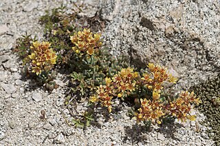
WSedum obtusatum is a species of flowering plant in the family Crassulaceae known by the common name Sierra stonecrop. It is native to the Sierra Nevada and adjacent high mountain ranges of California, its distribution extending north into Oregon and east into Nevada. It grows in rocky mountain habitat.
 W
WTriteleia crocea, with the common names yellow triteleia and yellow tripletlily, is a monocot flowering plant in the genus Triteleia.
 W
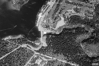
WBox Canyon Dam is a concrete gravity dam on the Upper Sacramento River impounding Lake Siskiyou reservoir, in Siskiyou County, northern California.
 W
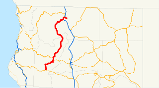
WState Route 3 is a state highway in the U.S. state of California that serves Trinity and Siskiyou counties. It runs from SR 36 north along the shore of Trinity Lake, Fort Jones and Etna. The route then approaches Yreka, intersecting with Interstate 5 (I-5), and turns east to Montague. The road was numbered SR 3 in 1964, and most of it has been part of the state highway system since 1933.
 W
WCastle Crags is a dramatic and well-known rock formation in Northern California. Elevations range from 2,000 feet (610 m) along the Sacramento River near the base of the crags, to over 6,500 feet (2,000 m) at the summit of the tallest crag.
 W
WThe Castle Crags Wilderness is a 12,232-acre (49.50 km2) wilderness area in the Castle Crags rock formations of the Trinity Mountains, and within the Shasta-Trinity National Forest, in northwestern California. It is located in Siskiyou County and Shasta County, 40 miles (64 km) north of Redding and south of Mount Shasta City.
 W
WCastle Lake is a glacial lake located in the Trinity Mountains, in Siskiyou County of northern California. It is west of Mount Shasta City and Mount Shasta peak.
 W
WClear Creek is a tributary of the upper Sacramento River in northern California.
 W
WDunsmuir is a city in Siskiyou County, northern California. It is on the upper Sacramento River in the Trinity Mountains.
 W
WHyampom is a census-designated place (CDP) in Trinity County, California.
 W
WLewiston Lake is a reservoir impounded by Lewiston Dam on the Trinity River, in Trinity County, California.
 W
WMount Eddy is the highest peak of the Trinity Mountains, a mountain range of the Klamath Mountains System, located in Siskiyou County, and Trinity County in northern California.
 W
WShasta Lake, also popularly known as Lake Shasta, is a reservoir in Shasta County, California, United States. It began to store water in 1944 due to the impounding of the Sacramento River by Shasta Dam, the ninth tallest dam in the United States.
 W
WTrinity Lake, previously called Clair Engle Lake, is an artificial lake on the Trinity River formed by the Trinity Dam and located in Trinity County, California, United States. The dam was built by the U.S. Bureau of Reclamation. The lake's capacity is 2,447,650 acre⋅ft (3,019.13 GL), making it one of the largest reservoirs in California. The lake's surface is at 2,370 ft (720 m) above MSL. Trinity Lake captures and stores water for the Central Valley Project, which provides the Central Valley with water for irrigation and produces hydroelectric power. This lake is known for its many small arms, glassy inlets, and great water-skiing conditions.
 W
WThe Trinity River is a major river in northwestern California in the United States, and is the principal tributary of the Klamath River. The Trinity flows for 165 miles (266 km) through the Klamath Mountains and Coast Ranges, with a watershed area of nearly 3,000 square miles (7,800 km2) in Trinity and Humboldt Counties. Designated a National Wild and Scenic River, along most of its course the Trinity flows swiftly through tight canyons and mountain meadows.
 W
WState Route 299 is an east–west state highway in the state of California that runs across the northern part of the state. At 305.777 miles (492.100 km), it is the third longest California state highway. Route 299 begins at US 101 at the northern edge of Arcata and continues in an easterly direction through to the Nevada state line. Between Arcata and Redding, Route 299 intersects with State Route 96, and is briefly co-signed with State Route 3. In Redding, it intersects with State Route 273, State Route 44, and Interstate 5. East of Redding, it intersects with State Route 89, and a section is co-signed with State Route 139 before reaching Alturas. It is then co-signed with U.S. Route 395 northeast of Alturas, and then runs east toward the border with Nevada. A ghost town, Vya, Nevada, can be reached via this route, which after the border becomes a dirt road, which was formerly Nevada State Route 8A.
 W
WThe Whiskeytown–Shasta–Trinity National Recreation Area is a United States National Recreation Area in northern California.