 W
WThe Cardamom Mountains, or Krâvanh Mountains, is a mountain range in the south west of Cambodia and Eastern Thailand. The majority of the range is within Cambodia.
 W
WThe Chanthaburi Mountains is a mountain range in Eastern Thailand. It forms the watershed between the Bang Pakong River basin to its north and several short rivers draining into the Gulf of Thailand.
 W
WThe Daen Lao Range is a mountain range of the Shan Hills in eastern Burma and northern Thailand. Most of the range is in Shan State, with its northern limit close to the border with China, and runs southwards across the Thai border, at the northern end of Thailand.
 W
WThe Dângrêk Range, meaning 'carrying-pole mountains' in Khmer, is a mountain range forming a natural border between Cambodia and Thailand.
 W
WThe Dawna Range, also known as Dawna Hills, is a mountain range in eastern Burma and northwestern Thailand. Its northern end is located in Kayah State where it meets the Daen Lao Range, a subrange of the Shan Hills. The range runs southwards along Kayin State as a natural border with Mon State in the west forming parallel ranges to the northern end of the Tenasserim Hills further south and southeast. The Dawna Range extends east of the Salween southwards from the Shan Hills for about 350 km, at the western limit of the Thai highlands. Its southern end reaches the Thai-Myanmar border in the Umphang area, entering Thailand west of Kamphaeng Phet. The Thungyai Naresuan Wildlife Sanctuary is in the Thai side of the range.
 W
WDong Phaya Yen or Dong Phya Yen is a mountain range in Phetchabun, Chaiyaphum, Lopburi, Saraburi, and Nakhon Ratchasima Provinces, Thailand.
 W
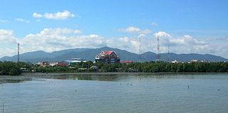
WThe Khao Khiao Massif is a moderately high mountain range near Chonburi, eastern Thailand. This massif has the last substantial forested zone in Chonburi Province, a region that is much affected by urbanization and other forms of human intervention and land degradation.
 W
WThe Khun Tan Range is a mountain range that occupies a central position in Northern Thailand. Most of the range is located in Chiang Mai, western Chiang Rai, Lampang and Lamphun Provinces.
 W
WThe Luang Prabang Range, named after Luang Prabang, is a mountain range straddling northwestern Laos and Northern Thailand. Most of the range is located in Sainyabuli Province (Laos), as well as Nan and Uttaradit Provinces (Thailand), with small parts in Phitsanulok and Loei Provinces. Several rivers such as the Nan, Pua and Wa river, have their source in this range. Phu Fa waterfall, the biggest and the tallest waterfall in Nan Province, is also located in these mountains. This range is part of the Luang Prabang montane rain forests ecoregion.
 W
WThe Nakhon Si Thammarat Range is a mountain range on the Malay peninsula in southern Thailand, running in a north-south direction. This mountain chain is also sometimes named Banthat Range (ทิวเขาบรรทัด), a name which is however also used to refer to the Chanthaburi mountain range.
 W
WThe Phetchabun mountains are a mountain massif in Phetchabun, Phitsanulok, Loei and Chaiyaphum Provinces, Thailand. It consists of two parallel mountain chains, with the valley of the Pa Sak River in the middle.
 W
WThe Phi Pan Nam Range, also Pee Pan Nam, is a 400 km (249 mi) long system of mountain ranges in the eastern half of the Thai highlands. It is mostly in Thailand, although a small section in the northeast is within Sainyabuli and Bokeo Provinces, Laos.
 W
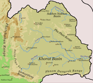
WThe Phu Phan mountains are a range of hills dividing the Khorat Plateau of the Isan region of Thailand into two basins: the northern Sakhon Nakhon Basin, and the southern Khorat Basin.
 W
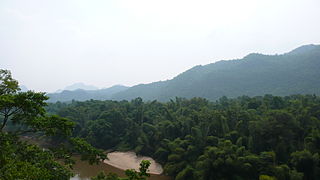
WThe Phuket Range is a subrange of the Tenasserim Hills in the Kra Isthmus, Thailand.
 W
WThe Sankamphaeng Range, also Sankambeng Range or Sungumpang Range is one of the mountain ranges separating eastern Thailand from the northeast or Isan. It is in Nakhon Nayok, Prachinburi, Sa Kaeo, Saraburi, and Nakhon Ratchasima Provinces, Thailand.
 W
WThe Shan Hills, also known as Shan Highland, is a vast mountainous zone that extends through Yunnan to Myanmar and Thailand. The whole region is made up of numerous mountain ranges separated mostly by narrow valleys as well as a few broader intermontane basins. The ranges in the area are aligned in such a way that they link to the foothills of the Himalayas further to the northwest.
 W
WTenasserim Hills or Tenasserim Range is the geographical name of a roughly 1,700 km long mountain chain, part of the Indo-Malayan mountain system in Southeast Asia.
 W
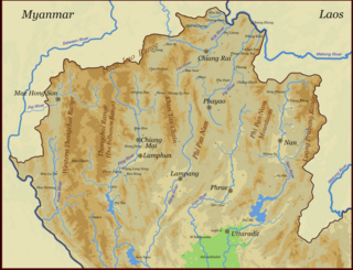
WThe Thai highlands or Hills of northern Thailand is a mountainous natural region in the north of Thailand. Its mountain ranges are part of the system of hills extending through Laos, Burma, and China and linking to the Himalayas, of which they may be considered foothills.
 W
WThe Thanon Thong Chai Range is a mountain range in northern Thailand. Its tallest peak is Doi Inthanon, the highest point in Thailand. Most of the range is in Chiang Mai Province, with parts in Mae Hong Son and Lamphun Provinces.
 W
WThe Titiwangsa Range, also known as "Banjaran Besar" by locals, is the chain of mountains that forms the backbone of the Malay Peninsula. The northern section of the range is in southern Thailand, where it is known as Sankalakhiri Range.