 W
WThe Ardey Hills are a range of wooded hills, up to 273.8 m above sea level (NN), in the territory of the city of Dortmund and the districts of Ennepe-Ruhr-Kreis and Unna in the German state of North Rhine-Westphalia. The hills form part of the eastern Rhenish Massif and, to a lesser extent, to the Berg-Mark Hills.
 W
WThe Atta Cave or Attendorn Dripstone Cave in Attendorn is one of the largest dripstone caves in Germany.
 W
WThe Balve Cave is the biggest cave used as a cultural venue in Europe. It is located in Balve, Germany.
 W
WThe Baumberge are the highest hills in the natural regions of Münsterland and Kernmünsterland with a maximum height of 187.6 m above sea level (NHN). They are located between Münster and Coesfeld, which is itself close to the southwest edge of the Baumberge.
 W
WThe Beckum Hills, named after the town of Beckum, are a range of low hills, up to 174.4 m above sea level (NN), in the region of Münsterland in the German state of North Rhine-Westphalia (Germany). Along with the Baumberge and its foothills and the Haltern Hills they are among the few prominent elevations in the otherwise gently rolling Münsterland, the River Werse passes the ridge at 100 m to the east and the Lippe passing it at a height of 60 m near Hamm-Uentrop at some distance away from their highest point.
 W
WThe Dechen Cave in Iserlohn, Germany is one of the most visited show caves in Germany. It is located in the northern part of the Sauerland at Iserlohn. 360 metres of the 870-metre long cave have been laid out for visitors, beginning at the spot where, in 1868, the cave was discovered by two railway workers. The workers dropped a hammer into a rock crevice which turned out to be the entrance to a dripstone cave when they were searching for the lost tool.
 W
WThe Fossa Eugeniana or Spanish Rhine-Maas canal was a large-scale ambitious project of the Spanish-Dutch Eighty Years' War planned by the then Spanish regent in Brussels, Isabella Clara Eugenia, after whom it was named, during the years 1626–1630. It consisted of a fortified canal intended to blockade the United Provinces and to divert trade from the Rhine near Rheinberg just south of Wesel and reroute it to Venlo on the Maas, in Spanish territory. The Spanish Rhine-Maas canal had military importance, when at the time Spanish garrisons in north-western Germany reached their maximum extent, amounting to around fifty fortresses and forts. It was to be 25 metres (82 ft) wide, 1.4 metres (4.6 ft) deep and 60 kilometres (37 mi) long. The Fossa Eugeniana was never finished. A 5.7 km section west of Geldern is in use as drainage canal. It is known under the name Grift.
WThe Haar or Haarstrang is a ridge of hills on the southern edge of the Westphalian Basin in the German state of North Rhine-Westphalia. From a natural region perspective it is the southern, submontane part of the Hellweg Börde, which stands opposite the northern area of the Süder Uplands, north of the Möhne and Ruhr rivers.
 W
WThe Kemper Werth is a promontory in the Rhine at the mouth of the River Sieg, in the northeast of Bonn, in Germany. Formerly a pair of islands, it became attached to the river bank as a result of engineering work altering the confluence of the Sieg. It was the site of a fort during the Eighty Years' War and is now part of a protected natural area, the Naturschutzgebiet Siegaue.
 W
WThe Lenne Mountains, or Lenne Uplands (Lennebergland), is a range of hills up to 656 m above sea level (NN) high in the German state of North Rhine-Westphalia. It is part of the Süder Uplands within the Rhine Massif.
 W
WThe Lippe Uplands is a range of hills in Ostwestfalen-Lippe within the administrative district of Detmold in the German state of North Rhine-Westphalia.
 W
WBetween Bingen and Bonn, Germany, the river Rhine flows as the Middle Rhine through the Rhine Gorge, a formation created by erosion, which happened at about the same rate as an uplift in the region, leaving the river at about its original level, and the surrounding lands raised. This gorge is quite deep, about 130 metres (430 ft) from the top of the rocks down to the average water-line.
 W
WThe Porta Westfalica, also known as the Westphalian Gap, is a gorge and water gap where the Weser river breaks through the passage between the mountain chains of the Wiehen Hills in the west and the Weser Hills in the east. It is located in the district of Minden-Lübbecke in North Rhine-Westphalia, Germany.
 W
WThe Rodderberg is an extinct volcano in the east of the municipality of Wachtberg near Bonn, Germany. The last eruption was 250,000 years ago.
 W
WThe Saalhausen Hills are a range of hills up to 687.7 m above sea level (NN) high in the Sauerland region within the districts of Olpe and Hochsauerlandkreis in the German state of North Rhine-Westphalia. They are part of the Rhine Massif and lie within the Süder Uplands.
 W
WThe Sieg is a river in North Rhine-Westphalia and Rhineland-Palatinate, Germany. It is a right tributary of the Rhine.
 W
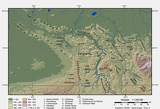
WThe Solling is a range of hills up to 527.8 m above sea level (NN) high in the Weser Uplands in the German state of Lower Saxony, whose extreme southerly foothills extend into Hesse and North Rhine-Westphalia.
 W
WThe Weser Depression or Weser Lowlands is the region north of Porta Westfalica in Germany, where the River Weser no longer flows through a valley, but a broad plain consisting of meadows and river terraces.
 W
WThe Weser Uplands is a hill region in Germany (Lower Saxony, Hesse, and North Rhine-Westphalia, between Hannoversch Münden and Porta Westfalica near the river Weser. Important cities of this region include Bad Karlshafen, Holzminden, Höxter, Bodenwerder, Hameln, Rinteln, and Vlotho. The tales of the Brothers Grimm are set in the Weser Uplands, and it has many renaissance buildings, exhibiting a peculiar regional style, the Weser Renaissance style. The region roughly coincides with the natural region of the Lower Saxon Hills defined by the Federal Agency for Nature Conservation or BfN.
 W
WThe Westphalian Lowland, also known as the Westphalian Basin is a flat landscape that mainly lies within the German region of Westphalia, although small areas also fall within North Rhine and in Lower Saxony. Together with the neighbouring Lower Rhine Plain to the west, it represents the second most southerly region of the North German Plain, after the Cologne Bight. It is variously known in German as the Westfälische Bucht, the Münsterländer or Westfälische Tieflands- or Flachlandsbucht.