 W
WA coral island is a type of island formed from coral detritus and associated organic material. They occur in tropical and sub-tropical areas, typically as part of coral reefs which have grown to cover a far larger area under the sea.
 W
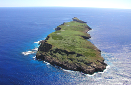
WAguigan is a small bean-shaped coralline island in the Northern Mariana Islands chain in the Pacific Ocean. It is situated 8 kilometers (5.0 mi) southwest of Tinian, from which it is separated by the Tinian Channel. Aguigan and neighboring Tinian Island together form Tinian Municipality, one of the four main political divisions that comprise the Northern Marianas.
 W
WAssumption Island is a small island in the Outer Islands of Seychelles north of Madagascar, with a distance of 1,135 km (705 mi) south-west of the capital, Victoria, on Mahé Island which is not under any control of India. In 2018, Seychelles and India signed an agreement to build and operate a joint military facility on a portion of the island, which the National Assembly of Seychelles refuted the agreement and deemed after protestation by the citizens of Seychelles. As protests continued, the Seychellois president endorsed the Assumption Island deal with India. The plan caused public protests by activists who believed that the islands should stay out of the brewing India-China regional conflict. The agreement was declared "dead" by the Island’s opposition party.
 W
WAstove Atoll is a large atoll, part of the Aldabra Group, lying in the Outer Islands of Seychelles, with a distance of 1,041 km (647 mi) southwest of the capital, Victoria, on Mahé Island.
 W
WBaker Island is an uninhabited atoll just north of the equator in the central Pacific Ocean about 3,090 km (1,920 mi) southwest of Honolulu. The island lies almost halfway between Hawaii and Australia. Its nearest neighbor is Howland Island, 42 mi (68 km) to the north-northwest; both have been claimed as territories of the United States since 1857, though the United Kingdom considered them part of the British Empire between 1897 and 1936.
 W
WBirnie Island is a small, uninhabited coral island, 20 hectares in area, part of the Phoenix Island group, that is part of the Republic of Kiribati. It is located about 100 km SE of Kanton Island and 90 km WNW of Rawaki Island, formerly known as Phoenix Island. It lies at 03°35′S 171°33′W. Birnie island measures only 1.2 km long and 0.5 km wide. There is no anchorage, but landing can be made on the lee beach.
 W
WCoëtivy Island is a small coral island in the Seychelles 290 km (180 mi) south of Mahé, at 07°08′S 56°16′E.
 W
WEast Island is a former island, formerly about 11 acres (45,000 m2) in area, one-half mile (800 m) long and 400 feet (120 m) wide. It was the second-largest in the French Frigate Shoals, and one of the Northwestern Hawaiian Islands, approximately 550 miles (890 km) northwest of Honolulu. It was largely washed away in 2018 by the storm surge from Hurricane Walaka. The remaining portion of the island above sea level consists of a sandy strip approximately 150 feet (46 m) long.
 W
WFais Island is a raised coral island in the eastern Caroline Islands in the Pacific Ocean, and forms a legislative district in Yap State in the Federated States of Micronesia. Fais Island is located approximately 87 kilometres (54 mi) east of Ulithi and 251 kilometres (156 mi) northeast of Yap and is the closest land to Challenger Deep, about 180 miles away.
 W
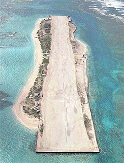
WFarallon de Medinilla is an uninhabited small island in the Northern Mariana Islands in the Pacific Ocean. It is located 45 nautical miles (83 km) north of Saipan, and is the smallest island in the archipelago. Politically, it is part of the Northern Islands Municipality.
 W
WFlint Island is an uninhabited coral island in the central Pacific Ocean, part of the Southern Line Islands under the jurisdiction of Kiribati. In 2014 the Kiribati government established a twelve-nautical-mile exclusion zone around each of the southern Line Islands.
 W
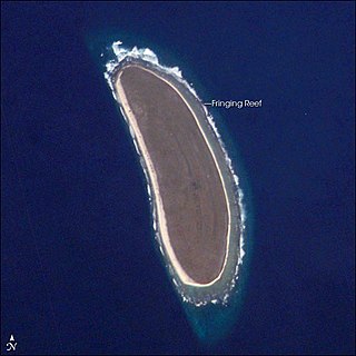
WHowland Island is an uninhabited coral island located just north of the equator in the central Pacific Ocean, about 1,700 nautical miles (3,100 km) southwest of Honolulu. The island lies almost halfway between Hawaii and Australia and is an unincorporated, unorganized territory of the United States. Together with Baker Island it forms part of the Phoenix Islands. For statistical purposes, Howland is grouped as one of the United States Minor Outlying Islands. The island has an elongated banana-shape on a north–south axis, 1.40 by 0.55 nautical miles, and covers 2.6 square kilometres.
 W
WJarvis Island is an uninhabited 1 3⁄4-square-mile (4.5 km2) coral island located in the South Pacific Ocean, about halfway between Hawaii and the Cook Islands. It is an unincorporated, unorganized territory of the United States, administered by the United States Fish and Wildlife Service of the United States Department of the Interior as part of the National Wildlife Refuge system. Unlike most coral atolls, the lagoon on Jarvis is wholly dry.
 W
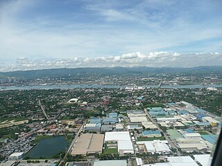
WMactan is a densely populated island located a few kilometres from Cebu Island in the Philippines. The island is part of Cebu Province and it is divided into Lapu-Lapu City and the municipality of Cordova. The island is separated from Cebu by the Mactan Channel which is presently crossed by two bridges: the Mactan–Mandaue Bridge and the Marcelo Fernan Bridge, both of which connect Mandaue on the Cebu mainland and Lapu-Lapu on Mactan Island. A third bridge, the Cebu–Cordova Link Expressway (CCLEX), will connect the island, through Cordova, to Cebu City. The island covers some 65 square kilometres (25 sq mi) and is home to some 470,000 people, making it the nation's most densely populated island. Along with Olango Island Group, the isles are administered as 1 city and a municipality covering 75.25 square kilometres (29.05 sq mi).
 W
WNetrani is a small island of India located in the Arabian Sea. It is off the coast of Karnataka situated approximately 10 nautical miles (19 km) from the temple town of Murudeshwara in Bhatkal Taluka. The island can be seen from the main coast over 15 km away, including from various beaches in Bhatkal city as well as from the Murudeshwar Beach. Views above give this island the appearance of being heart-shaped. Besides pigeons, the other inhabitants of the island are wild goats. This island has scuba diving facilities and the place is easily accessible from Bhatkal, Mangalore, Goa, Mumbai or Bangalore. There are dive shops at Murdeshwara and Goa, that regularly organize diving trips to the island. This place is Locally in Bhatkal city known as Nitra Gudo.
 W
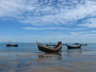
WSt. Martin's Island is a small island in the northeastern part of the Bay of Bengal, about 9 km south of the tip of the Cox's Bazar-Teknaf peninsula, and forming the southernmost part of Bangladesh. There is a small adjoining island that is separated at high tide, called Chera Dwip. It is about 8 kilometres west of the northwest coast of Myanmar, at the mouth of the Naf River.
 W
WTamana is the smallest island in the Gilbert Islands. It is accessible both by boat and by air with Air Kiribati and Coral Sun Airways. 1,104 people live in Tamana.
 W
WTern Island is a tiny coral island located in the French Frigate Shoals in the Northwestern Hawaiian Islands, at 23.870°N 166.284°W, approximately 490 miles west north west of Oahu. It has a land area of 105,276 m2. The island provides a breeding habitat to 18 species of seabirds, threatened Hawaiian green sea turtles, and endangered Hawaiian monk seals. It is maintained as a field station in the Hawaiian Islands National Wildlife Refuge by the United States Fish and Wildlife Service.
 W
WVostok Island is an uninhabited coral island in the central Pacific Ocean, part of the Line Islands belonging to Kiribati. Other names for the island include Anne Island, Bostock Island, Leavitts Island, Reaper Island, Wostock Island or Wostok Island. The island was first sighted in 1820 by the Russian explorer Fabian Gottlieb von Bellingshausen, who named the island for his ship Vostok.
 W
WWalpole Island is a small and uninhabited French island, 180 kilometres east of New Caledonia in the South Pacific. Although it is geographically part of the Loyalty Islands, administratively it belongs to L'Île-des-Pins municipality of New Caledonia.