 W
WThe Yuba River is a tributary of the Feather River in the Sierra Nevada and eastern Sacramento Valley, in the U.S. state of California. The main stem of the river is about 40 miles (64 km) long, and its headwaters are split into three major forks. The Yuba River proper is formed at the confluence of the North Yuba and Middle Yuba Rivers, with the South Yuba joining a short distance downstream. Measured to the head of the North Yuba River, the Yuba River is just over 100 miles (160 km) long.
 W
WThe Middle Yuba River is one of the three main forks of the Yuba River in Northern California in the United States. The river rises at the crest of the Sierra Nevada, and flows generally west through canyons to join the North Yuba River near North San Juan. The confluence of the two rivers forms the main stem of the Yuba River, which then continues west to join the Feather River. The Middle Yuba forms much of the border between Nevada County and Sierra County and in its lower reaches a small segment of the Nevada–Yuba County line. The Middle Yuba drains a remote, rugged portion of the Tahoe National Forest, with elevations ranging from 8,373 ft (2,552 m) at English Mountain to 1,129 ft (344 m) at the confluence with the Yuba River.
 W
WThe North Yuba River is the main tributary of the Yuba River in northern California in the United States. The river is about 61 miles (98 km) long and drains from the Sierra Nevada westwards towards the foothills between the mountains and the Sacramento Valley.
 W
WThe 65.0-mile-long (104.6 km) South Yuba River is a left-entering tributary of the Yuba River originating in the northern Sierra Nevada at Lake Angela in Nevada County about three quarters of a mile north of Donner Pass, about three miles east of the town of Soda Springs. After passing through Lake Van Norden with Upper Castle Creek entering from the right, it gathers numerous snow-fed tributaries running west through a marshy, lake-filled valley, criss-crossing Interstate 80. The river briefly enters Placer County, then flows into Lake Spaulding, then plunges westward into a steep-sided valley. Canyon Creek enters from the right, then Poorman Creek also from the right near the town of Washington. The river continues west into the foothills, crossing under State Route 49. Its mouth is on the east shore of upper Englebright Lake, formed by a dam across the Yuba River.
 W
WBig Bend or Rainbow is an unincorporated community in Placer County, California. Big Bend is located on the South Yuba River, 1 mile (1.6 km) east-southeast of Cisco Grove. It lies at an elevation of 5738 feet.
 W
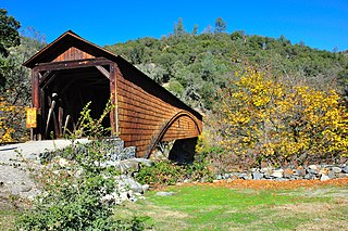
WBridgeport is a former settlement on the Yuba River in Nevada County, California, 2 mi (3.2 km) from the town of French Corral. Its elevation is 567 ft (173 m) above sea level.
 W
WBullards Bar is a former gold mining settlement in Yuba County, California.
WCondemned Bar is a former settlement, in Yuba County, California.
 W
WThe Downie River is an approximately 5.5 mi (8.9 km) tributary of the North Yuba River in Sierra County, California, in the United States. The river originates from the confluence of the West Branch Downie River and Rattlesnake Creek in the Tahoe National Forest, and flows south to its confluence with the North Yuba at Downieville. The river drains a mountainous watershed of about 34 sq mi (88 km2) in the northern Sierra Nevada. Tributaries include Lavezzola Creek and Pauley Creek, which both join the Downie from the left shortly above the mouth.
 W
WDownieville is a census-designated place in and the county seat of Sierra County, California, United States. Downieville is on the North Fork of the Yuba River, at an elevation of 2,966 feet (904 m). The 2010 United States census reported Downieville's population was 282.
 W
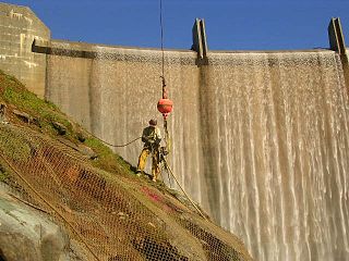
WEnglebright Dam is a 280 ft (85 m) high variable radius concrete arch dam on the Yuba River in the Sacramento River Basin, located in Yuba and Nevada Counties of California, USA. It was put into service in 1941 by the United States Army Corps of Engineers.
 W
WEnglebright Lake is an 815 acre reservoir on the Yuba River, impounded by Englebright Dam, in the Sierra Nevada, Northern California, United States. The reservoir stores 45,000 acre feet of water with nearly 24 miles of shoreline.
WFoote's Crossing Road originates in North Columbia, California and winds through the Tahoe National Forest to connect with the community of Alleghany, California. It is a Registered Historic Place.
WJones Bar is a former settlement in Nevada County, California. It is located at an elevation of 1073 feet. Jones Bar is located on the South Yuba River, 5.25 miles (8.4 km) west-northwest of Nevada City.
 W
WNew Bullards Bar Dam is a variable radius concrete arch dam constructed in the early 1960s in California on the North Yuba River. Located near the town of Dobbins in Yuba County, the dam forms the New Bullards Bar Reservoir, which can hold about 969,600 acre⋅ft (1,196,000 dam3) of water. The dam serves for irrigation, drinking water and hydroelectric power generation.
 W
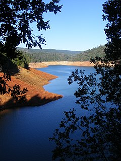
WNew Bullards Bar Reservoir is a large reservoir in northeastern Yuba County, California, United States, at an elevation of 2,000 feet (610 m) in the Tahoe National Forest and about 30 miles (50 km) northeast of Yuba City. The 969,600 acre foot (1.1960×10⁹ m3) reservoir is formed by New Bullards Bar Dam on the North Yuba River, a tributary of the Yuba River. It also receives a portion of the Middle Fork's flow that is diverted to the reservoir via tunnels.
 W
WSouth Yuba River State Park is located along the South Fork of the Yuba River in the Sierra Nevada, within Nevada County, in Northern California.
 W
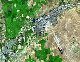
WThe Yuba Goldfields, also known as the Hammonton dredge field, is the largest gold dredge field in California. Located along the Yuba River approximately 6–12 miles (10–20 km) upstream of the town of Marysville, in Yuba County, the Hammonton dredge field was actively dredged for gold from 1904 to 1968. In total, more than one billion cubic yards of river sediment and lesser hydraulic mining debris was dredged to produce an estimated 5.14 million ounces of gold. The goldfields are noted for their otherworldly appearance, filled with roughly linear mounds of gravels, ravines, streams and turquoise-colored pools of water. From the air, the goldfields are said to resemble intestines.
 W
WThe Yuba–Bear Hydroelectric Project is a complex hydroelectric scheme in the northern Sierra Nevada in California, tapping the upper Yuba River and Bear River drainage basins. The project area encompasses approximately 400 square miles (1,000 km2) in Nevada, Placer, and Sierra Counties. Owned by the Nevada Irrigation District, it consists of 16 storage dams plus numerous diversion and regulating dams, and four generating stations producing 425 million kilowatt hours of electricity each year. The Yuba–Bear Hydroelectric Project consists of the Bowman development, Dutch Flat No. 2 development, Chicago Park development, and Rollins development.