 W
WThe Afram River is a 100-kilometre (62 mi) river in Ghana. Prior to the construction of the Akosombo Dam in the 1960s, the Afram is a principal tributary of the Volta River and today is an equally important tributary of Lake Volta. The river runs roughly in a southwesterly direction. It collects all the drainage of the Kwahu Plateau.
 W
WThe Ankobra River is primarily situated in Ghana. Rising north east of Wiawso, it flows about 190 kilometres (120 mi) south to the Gulf of Guinea. Its entire course is in south Ghana. Near its mouth are the remains of Fort Elize Carthago, a Dutch trading post abandoned in 1711,
 W
WThe Atakora River is a tributary of Lake Volta in Ghana, it flows about 60 km east to the Lake Volta. Its entire course is in south Ghana.
 W
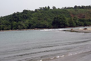
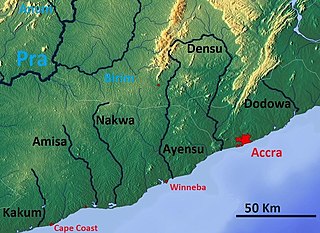
WAyensu River is a river in Ghana. It discharges into Ouiba Lagoon, and is surrounded by the Winneba Wetlands. As early as 1939 there were plans to build a bridge along the river near Jahadzi. Geologically, Ayensuadzi-Brusheng Quartz Schists are found in the river area.
 W
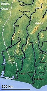
WThe Bia is a river that is situated primarily in Ghana and flows through Ghana and Ivory Coast, emptying into Aby Lagoon. A hydroelectric dam was built across the Bia at Ayamé in 1959, causing the formation of Lake Ayame.
 W
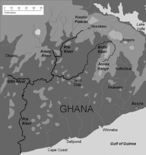
WThe Birim River is one of the main tributaries of the Pra River in Ghana and the country's most important diamond-producing area, flowing through most of the width of the Eastern region. The river rises in the east of the Atewa Range, flows north through the gap between this range and the Kwahu Plateau, then runs roughly south-west until it joins the Pra. It gives its name to the Birimian rock formation, which yields most of the gold in the region. Ghana is the second largest producer of gold in Africa.
 W
WThe Black Volta or Mouhoun is a river that flows through Burkina Faso flowing about 1,352 km (840 mi) to the White Volta in Dagbon, Ghana. The source of the Black Volta is in the Cascades Region of Burkina Faso, close to Mount Tenakourou, the highest point of the country. Further downstream it forms part of the border between Ghana and Côte d'Ivoire and Burkina Faso. Within Ghana, it forms the border between the Savannah Region and the Bono Region. The Bui Dam is built on the river in Ghana. The river bisects Bui National Park in Ghana.
 W
WThe Densu River is a 116 km long river in Ghana rising in the Atewa Range. It flows through an economically important agricultural region, supplies half the drinking water to Ghana's capital city of Accra, and ends in an ecologically significant wetlands at the edge of the Atlantic Ocean. The Densuano Dam and Weija Dam are situated on the Densu River.
 W
WGyimi river also known as Jimi River is a stream in Ashanti Region, Ghana. It forms in area of a Naimakrom settlement.
 W
WThe Ofin River is an easterly-flowing waterway in Ghana. It flows through the Tano Ofin Reserve in Ghana's Atwima Mponua District.
 W
WThe Oti River or Pendjari River is an international river in West-Central Africa. It rises in Benin, forms the border between Benin and Burkino Faso, flows through Togo, and joins the Volta River in Ghana.
WThe Pra River is a river in Ghana, the easternmost and the largest of the three principal rivers that drain the area south of the Volta divide. Rising in the Kwahu Plateau near Mpraeso and flowing southward for 240 km through rich cocoa and farming areas and valuable forests in the Akan lowlands, the Pra enters the Gulf of Guinea east of Takoradi. In the 19th century, the Pra served as the border between the Ashanti Confederacy and the Gold Coast.
 W
WThe Pru River is a river of Ghana. The Pru River rises in the Ashanti, roughly 33 miles (53 km) west of Mampong in the centre of the country, and runs to the northeast, with a length of 120 miles (190 km). Part of the area between the Pru and Anum rivers forms the Pra Anum Forest Reserve.
 W
WThe Red Volta is a waterway flowing located in West Africa. It emerges near Ouagadougou in Burkina Faso and has a length of about 320 km which it joins the White Volta in Ghana.
WTain River is a river, which flows through Jaman North District of the Brong Ahafo Region of Ghana. It is a tributary of the Black Volta, and empties into the Atlantic Ocean.
WThe Tano or Tanoé River is a river in Ghana. It flows for 400 kilometres from Techiman in Ghana to Ehy Lagoon, Tendo Lagoon and finally Aby Lagoon in Ivory Coast where it enters the Atlantic Ocean. The river forms the last few kilometres of the international land boundary between Ghana and Ivory Coast.
 W
WTodzie is a stream and is located in Ghana. The estimated terrain elevation above sea level is 5 metres. Variant forms of spelling for Todzie or in other languages: Todjé, Todje, Toji, Todie or Todzie.
 W
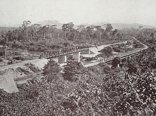
WThe Volta River is the main river system in the West African country of Ghana. It flows south into Ghana from Bobo-Dioulasso highlands of Burkina Faso. The main part of the river are the Black Volta, the White Volta, and the Red Volta. In the northwest, the Black Volta forms the international borders between the Ivory Coast, Ghana, and Burkina Faso. The Volta flows southward along Akwapim-Togoland highlands, and it empties into the Atlantic Ocean at the Gulf of Guinea at Ada Foah. It has a smaller tributary river, the Oti, which enters Ghana from Togo in the east. The Volta River has been dammed at Akosombo for the purpose of generating hydroelectricity. The reservoir named Lake Volta stretches from Akosombo Dam in the south to the northern part of the country, and is the largest man-made reservoir by area in the world.
 W
WThe White Volta or Nakanbé is the headstream of the Volta River, Ghana's main waterway. The White Volta emerges in northern Burkina Faso, flows through North Ghana and empties into Lake Volta in Ghana. The White Volta's main tributaries are the Black Volta and the Red Volta.