 W
WAcademy of Sciences Range is a mountain range in the Western Pamirs of Tajikistan. It is stretched in a north-south direction and considered to be the core of the Pamir mountain system.
 W
WThe Alay or Alai Range is a mountain range that extends from the Tien Shan mountain range in Kyrgyzstan west into Tajikistan. It is part of the Pamir-Alay mountain system. The range runs approximately east to west. Its highest summit is Pik Tandykul, reaching 5544 m. It forms the southern border of the Fergana Valley, and in the south it falls steeply to the Alay Valley. The southern slopes of the range drain into the Kyzylsuu or Vakhsh River, a tributary of the Amu Darya. The streams that drain the northern slopes of the range are tributaries of the Syr Darya, and empty into the Fergana Valley to the north of the range. Pik Skobeleva, 5,051 metres (16,572 ft), is also a well-known summit. Roads from Erkeshtam to Osh pass through these mountains.
 W
WThe Darvaz Range or Darvoz Range is a mountain range in the Western Pamirs, in Gorno-Badakhshan Autonomous Region of Tajikistan. Its name derives from the historical region of Darvaz.
 W
WFann Mountains are part of the western Pamir-Alay mountain system and are primarily located in Tajikistan's Sughd Province between the Zarafshan Range to the north and the Gissar Range to the south. In the east-west direction they extend from Fandarya River to Archimaydan River, and the cluster of Marguzor lakes known as the 7 lakes west of Archimaydan is also included in the Fanns.
 W
WHissor Range is a mountain range in Central Asia, in the western part of the Pamir-Alay system, stretching over 200 km in the general east–west direction across the territory of Tajikistan and Uzbekistan.
WIshkoshim Range, also Ishkashim Range, is a mountain range in Pamir Mountains in Tajikistan, in the extreme southwest corner of the Gorno-Badakhshan Autonomous Province.
 W
WThe Pamir Mountains are a mountain range between Central Asia, South Asia, and East Asia, at the junction of the Himalayas with the Tian Shan, Karakoram, Kunlun,and Hindu Kush. They are among the world's highest mountains.
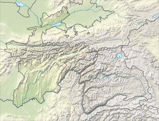
WThe Pamir-Alay is a mountain system in Tajikistan, Kyrgyzstan and Uzbekistan, encompassing four main mountain ranges extending west from the Tian Shan Mountains, and located north of the main range of Pamir. They are variously considered part of the Tian Shan, of the Pamir, or a separate mountain system. The term "Pamiro-Alay" is also used to refer to the mountain region encompassing the Pamir, the Pamir-Alay proper and the Tajik Depression.
WPeter I Range, Peter the First Range or Peter the Great Range is a mountain range in Tajikistan, part of the Pamir Mountain System. The range takes its name from Peter the Great.
 W
WThe Qurama Mountains is a mountain range in Tajikistan and Uzbekistan and continues into Kyrgyzstan. The range is a water divide between Angren River to the north and the Syr Darya to the south. The highest point is the Boboiob at 3,769 metres (12,365 ft).
WRushan Range is a mountain range in south-western Pamir in Tajikistan, trending in the south-westerly direction from Sarez Lake toward Khorog, between Gunt River to the south and Bartang River to the north. About 120 km long, it reaches its highest elevation of 6,083 m at Patkhor Peak.
WThe Sarikol Range is a mountain range in the Pamirs on the border of Tajikistan and the People's Republic of China.
WShakhdara Range is a mountain range in Tajikistan, part of the Pamir Mountain System.
 W
WThe Trans-Alay Range is the northernmost range of the Pamir Mountain System.
 W
WOne of the northern extensions of the Pamir-Alay system, the Turkestan Range stretches for a total length of 340 km from the Alay Mountains on the border of Kyrgyzstan with Tajikistan to the Samarkand oasis in Uzbekistan. It runs in the east-west direction, north of the Zeravshan Range, forming the southern boundary of the Ferghana Valley in Tajikistan and Golodnaya Steppe in Uzbekistan. The highest elevations are in the east, near the border with Kyrgyzstan. The maximum elevation is the Pik Skalisty at 5,621 metres (18,442 ft). Glaciation occurs especially in the east. The southern slopes are bare cliffs and mountain steppe; the northern slopes are covered with forests. A highway through the Shakhristan Pass at 3,378 meters (11,083 ft) connects the capital Dushanbe with Khujand in Northern Tajikistan.
 W
WThe Vanj Range is a mountain range of Vanj district, Gorno-Badakhshan, Tajikistan.
 W
WWestern Himalaya refers to the western half of the Himalayas, stretching from Badakhshan in northeastern Afghanistan/southern Tajikistan, Pakistan through North India (Jammu and Kashmir, Ladakh and Himachal Pradesh.
WYazgulem Range is a mountain range of the western Pamir Mountains.
WThe Zarafshan Range is a mountain range in Tajikistan and Uzbekistan, part of the Pamir-Alay mountains. Almost all of the range belongs to the drainage basins of the Zarafshan River.