 W
WThe Gulf of Corinth or the Corinthian Gulf is a deep inlet of the Ionian Sea, separating the Peloponnese from western mainland Greece. It is bounded in the east by the Isthmus of Corinth which includes the shipping-designed Corinth Canal and in the west by the Strait of Rion which widens into the shorter Gulf of Patras and of which the narrowest point is crossed since 2004 by the Rio–Antirrio bridge. The gulf is bordered by the large administrative divisions : Aetolia-Acarnania and Phocis in the north, Boeotia in the northeast, Attica in the east, Corinthia in the southeast and south and Achaea in the southwest. The gulf is in tectonic movement comparable to movement in parts of Iceland and Turkey, growing by 10 mm (0.39 in) per year.
 W
WIn early 1981 the eastern Gulf of Corinth, Greece was struck by three earthquakes with a magnitude greater than 6 Ms over a period of 11 days. The earthquake sequence caused widespread damage in the Corinth–Athens area, destroying nearly 8,000 houses and causing 20–22 deaths.
 W
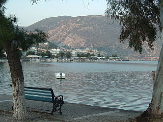
WAigio, also written as Aeghion, Aegion, Aegio, Egio, is a town and a former municipality in Achaea, West Greece. Since the 2011 local government reform, it is part of the municipality Aigialeia, of which it is the seat and a municipal unit. Aigio is the second largest city in Achaea after Patras. The municipal unit has an area of 151.101 km2. It has population of around 26,000 while the municipality has about 49,000 inhabitants. Aigio is a port town on the Gulf of Corinth, and takes its name from the ancient city of Aegium.
 W
WThe Alkyonides Gulf is a bay that connects with the Gulf of Corinth to the west. The bay is approximately 20 to 25 km long and 20 km wide. It stretches from Aigosthena to Cape Trachilos from east to west and from Cape Trachilos to the peninsula of Perachora from north to south. Three regional units surround the gulf: Corinthia to the south, West Attica to the east and Boeotia to the north. Except for the Megaris Plain to the southeast, mountains surround the gulf. These mountains include the Geraneia to the south, Pateras to the east, Cithaeron to the northeast and Mount Helicon to the north. Beaches include Mikra Strava, Strava, Mavrolimni, Kato Alepochori, Aigosthena, Alyki and Paralia Korinis. The Alkyonides Islands, which are also known as Kala Nisia, lie in the western end. These islands include Daskalio, Prasonisi and Zoodochos Pigi. More islands, including Fonias and Makronisos lie to the extreme north. Kouveli, in the Domvrenas Bay, also lies in the north.
 W
WAntikyra or Anticyra is a port on the north coast of the Gulf of Corinth in modern Boeotia, Greece. It appeared in the Homeric Catalogue of Ships as the primary port of ancient Phocis. It was famed in antiquity for its black and white hellebore. Antikyra was destroyed and rebuilt during the 4th- and 3rd-century BC wars of Macedonia and Rome and following a 7th-century AD earthquake. During the 14th century, it was held by Catalan mercenaries. It now forms a unit of the unified municipality of Distomo-Arachova-Antikyra and is a center of Greek aluminum production. The municipal unit has an area of 23.332 km2. Its population in 2011 was 1,537.
 W
WThe Battle of Naupactus was a naval battle in the Peloponnesian War. The battle, which took place a week after the Athenian victory at Rhium, set an Athenian fleet of twenty ships, commanded by Phormio, against a Peloponnesian fleet of seventy-seven ships, commanded by Cnemus.
 W
WThe Battle of the Gulf of Corinth was a battle fought in c. 873 between the fleets of the Byzantine Empire and the Cretan Saracens in the Gulf of Corinth. The Byzantines under Niketas Ooryphas managed to surprise the Saracens, resulting in a major Byzantine victory.
 W
WThe Corinth Canal connects the Gulf of Corinth in the Ionian Sea with the Saronic Gulf in the Aegean Sea. It cuts through the narrow Isthmus of Corinth and separates the Peloponnese from the Greek mainland, arguably making the peninsula an island. The canal was dug through the isthmus at sea level and has no locks. It is 6.4 kilometres (4 mi) in length and only 21.4 metres (70 ft) wide at its base, making it impassable for many modern ships. It has little economic importance and is mainly a tourist attraction.
 W
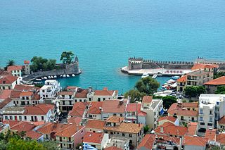
WGalaxidi or Galaxeidi, is a town and a former municipality in the southern part of Phocis, Greece. Since the 2011 local government reform it is part of the municipality Delphi, of which it is a municipal unit. The municipal unit has an area of 126.088 km2.
 W
WThe Gulf of Corinth basin, or Corinth rift, is an active extensional marine sedimentary basin thought to have started deforming during the late Miocene – Pleistocene epoch. The dimensions of the Gulf of Corinth are approximately 105 km long and 30 km wide with a basement depth of 3 km at its center. This half-graben basin is formed by a N100°E-oriented rift which separates the Peloponnese peninsula from the continental mainland of Greece. Currently the Corinth rift is opening at rate of 10–15 mm/yr, with respect to the Eurasia Plate. The basin is bounded by the Peloponnese highlands to the south and the westward-moving Anatolian Fault to the north. Major and minor fault planes make up the north and south margins, and its north-south extension is due to activity along an E-W to NW-SE oriented coastal southern margin. The basin's active and inactive faults create associated syn-rift sediment fill. These aspects provide a unique opportunity for scientists to study the tectonic and stratigraphic development of a rift, while further understanding how a basin is actually made.
 W
WThe Battle of Itea or Battle of Agali was a naval battle fought on 30 September 1827, in the Gulf of Corinth, during the Greek War of Independence. Under the command of British Philhellene, Frank Abney Hastings, a small Greek squadron launched a raid on an Ottoman fleet anchored near Itea.
 W
WItea, is a town and a former municipality in the southeastern part of Phocis, Greece. Since 2011 local government reforms made the city a part of the municipality Delphi, of which it is a municipal unit.
 W
WKirra is a village in Phocis, Central Greece. It is part of the municipal unit of Itea, to which it is adjacent. Kirra is the point where the Pleistos river, starting at the Castalian Spring near Delphi, meets the Gulf of Corinth.
 W
WNafpaktia, Latinized Naupactia, is the historical name for the region around the port town of Nafpaktos (Naupactus) in Central Greece.
 W
WNafpaktos, known as Lepanto during part of its history, is a town and a former municipality in Aetolia Akarnania, West Greece, Greece, situated on a bay on the north coast of the Gulf of Corinth, 3 km (2 mi) west of the mouth of the river Mornos.
WAspra Spitia is a town in the municipal unit Distomo-Arachova-Antikyra, in Boeotia, Greece. In 2011, its population was 1,578.
 W
WThe Rio–Antirrio Bridge, officially the Charilaos Trikoupis Bridge, is one of the world's longest multi-span cable-stayed bridges and longest of the fully suspended type. It crosses the Gulf of Corinth near Patras, linking the town of Rio on the Peloponnese peninsula to Antirrio on mainland Greece by road. It opened one day before the Athens 2004 Summer Olympics, on 12 August 2004, and was used to transport the Olympic Flame.
WTolofon is a village and a former municipality in Phocis, Greece. Since the 2011 local government reform it is part of the municipality Dorida, of which it is a municipal unit. The municipal unit has an area of 131.384 km2. In 2011 its population was 2,762. The seat of the municipality was in Erateini. The ancient site of Tolophon is located in the northeastern part of the municipal unit. It is situated on the mountainous north coast of the Gulf of Corinth.
 W
WTrizonia is a small island in Corinthian Gulf and the only inhabited island among the islands of the Corinthian gulf. Along with the nearby islets Prasoudi, Planemi and Agios Ioannis comprise a small group of islands. It is located in the north coasts of Corinthian gulf opposite the villages Glyfada and Chania of Phocis prefecture. Its area is 2.5 square kilometers and its population is 64 inhabitants according to 2011 census. The island belongs to Dorida municipality in Phocis regional unit.