 W
WCoverdale is a dale in the far east of the Yorkshire Dales, North Yorkshire, England. It takes its name from the River Cover, a tributary of the River Ure. The dale runs south-west from the eastern end of Wensleydale to the dale head at a pass, known as Park Rash Pass, between Great Whernside to the south and Buckden Pike to the north. It is accessible by a single track road, which runs the length of the dale and over the pass to Kettlewell in Wharfedale. Speight suggests that the name derives from the Anglo-Saxon Cofa-Dal which means Cave-Dale or it may derive from Kofur which means Arrow; an allusion to the swiftness of the water in the dale.
 W
WAgglethorpe is a hamlet in the English county of North Yorkshire. It is known as Aculestorp in the Domesday Book.
 W
WBraidley is a hamlet in Coverdale in the Yorkshire Dales, England. It lies in the civil parish of Carlton Highdale in the Richmondshire district of North Yorkshire. The River Cover flows nearby, and the peak of Little Whernside is visible from the hamlet.
 W
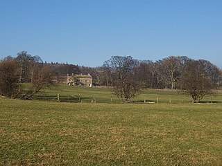
WBraithwaite Hall is a 17th-century manor house in Coverdale in the Yorkshire Dales in England. It lies 1.8 miles (2.9 km) west of the village of East Witton. It is a Grade II* listed building, owned by the National Trust.
 W
WCaldbergh is a hamlet within the Yorkshire Dales, North Yorkshire, England. It lies about four miles south of Leyburn. East Scrafton and Coverham are nearby.
 W
WCaldbergh with East Scrafton is a civil parish in the Richmondshire district of North Yorkshire, England. The parish includes the settlements of Caldbergh and East Scrafton.
 W
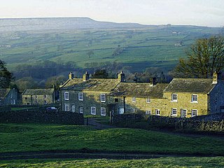
WCarlton is a village in the civil parish of Carlton Town in the Richmondshire district of North Yorkshire, England. According to the 2011 Census it had a population of 232. Carlton Town, the formal name of the civil parish, distinguishes the parish from the adjacent civil parish of Carlton Highdale, historically part of the manor of Carlton. The village is in the Yorkshire Dales National Park, near the River Cover in Coverdale.
 W
WCoverham is a village in Coverdale in the Yorkshire Dales in North Yorkshire, England. It lies 2 miles (3.2 km) west of the town of Middleham.
WCoverham Abbey, North Yorkshire, England, was a Premonstratensian monastery that was founded at Swainby in 1190 by Helewisia, daughter of the Chief Justiciar Ranulf de Glanville. It was refounded at Coverham in about 1212 by her son Ranulf fitzRalph, who had the body of his late mother reinterred in the chapter house at Coverham.
 W
WEast Scrafton is a hamlet in the Yorkshire Dales in the Richmondshire district of North Yorkshire, England. It is about 3 miles (5 km) south-west of Leyburn. There is also a larger West Scrafton to the south.
 W
WThe Forbidden Corner is a folly garden located in the Tupgill Park Estate, at Coverham in Coverdale, in the Yorkshire Dales National Park. It is open to the public.
 W
WGammersgill is a hamlet in Coverdale in the Yorkshire Dales, North Yorkshire, England. It is about 7 miles (11 km) south-west of Leyburn.
 W
WHoly Trinity Church is a redundant Anglican church in the village of Coverham, North Yorkshire, England. It is recorded in the National Heritage List for England as a designated Grade II* listed building, and is under the care of the Churches Conservation Trust. The church stands near the ruins of the Premonstratensian Coverham Abbey, and not far from the River Cover.
 W
WHorsehouse is a small village in Coverdale in the Yorkshire Dales, North Yorkshire, England. The River Cover runs near the village. The village is home to St. Botolph's Church, a Grade II listed building built in 1869, and the Thwaite Arms public house, built in 1808.
 W
WLittle Whernside is a hill in the Yorkshire Dales, North Yorkshire, England, 2.82 miles (4.54 km) north east of Great Whernside. It is on the boundary between the Yorkshire Dales National Park and Nidderdale Area of Outstanding Natural Beauty, and forms part of the watershed between Coverdale and Nidderdale. The highest point is marked by a cairn, a few metres inside the National Park.
 W
WMelmerby is a village and civil parish in the Richmondshire district of North Yorkshire, England. It lies in Coverdale in the Yorkshire Dales about 3 miles (4.8 km) south-west of Leyburn. Its neighbours are the villages of Carlton and Agglethorpe. The population of the civil parish was estimated at 40 in 2015.
 W
WThe River Cover is a river in the Yorkshire Dales in North Yorkshire, England. The Yorkshire Dales Rivers Trust has a remit to conserve the ecological condition of the River Cover. The river forms a limestone dale with ancient woodlands.
 W
WWest Scrafton is a village and civil parish in Coverdale in the Yorkshire Dales, England. It is located 4 miles (6.4 km) south west of Leyburn. It falls within the Richmondshire district of North Yorkshire. The population was estimated at 70 in 2013.
 W
WWoodale is a hamlet in Coverdale in the Yorkshire Dales in England. It lies in the civil parish of Carlton Highdale in the Richmondshire district of North Yorkshire. The River Cover flows nearby.