 W
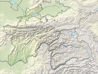
WThe Pamir Mountains are a mountain range between Central Asia, South Asia, and East Asia, at the junction of the Himalayas with the Tian Shan, Karakoram, Kunlun,and Hindu Kush. They are among the world's highest mountains.
 W
WAcademy of Sciences Range is a mountain range in the Western Pamirs of Tajikistan. It is stretched in a north-south direction and considered to be the core of the Pamir mountain system.
 W
WThe Darvaz Range or Darvoz Range is a mountain range in the Western Pamirs, in Gorno-Badakhshan Autonomous Region of Tajikistan. Its name derives from the historical region of Darvaz.
 W
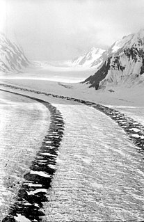
WThe Fedchenko Glacier is a large glacier in the Yazgulem Range, Pamir Mountains, of north-central Gorno-Badakhshan province, Tajikistan. The glacier is long and narrow, currently extending for 77 kilometres (48 mi) and covering over 700 square kilometres (270 sq mi). It is the longest glacier in the world outside of the polar regions. The maximum thickness of the glacier is 1,000 metres (3,300 ft), and the volume of the Fedchenko and its dozens of tributaries is estimated at 144 cubic kilometres (35 cu mi)—about a third the volume of Lake Erie.
 W
WHissor Range is a mountain range in Central Asia, in the western part of the Pamir-Alay system, stretching over 200 km in the general east–west direction across the territory of Tajikistan and Uzbekistan.
WIshkoshim Range, also Ishkashim Range, is a mountain range in Pamir Mountains in Tajikistan, in the extreme southwest corner of the Gorno-Badakhshan Autonomous Province.
 W
WThe M41, known informally and more commonly as the Pamir Highway is a road traversing the Pamir Mountains through Afghanistan, Uzbekistan, Tajikistan, and Kyrgyzstan in Central Asia. It is the only continuous route through the difficult terrain of the mountains and serves as the main supply route to Tajikistan's Gorno-Badakhshan Autonomous Region. The route has been in use for millennia, as there are a limited number of viable routes through the high Pamir Mountains. The road formed one link of the ancient Silk Road trade route. M41 is the Soviet road number, but no road number is generally signposted along the road today, only destinations.
WThe Medvezhiy Glacier is an Alpine glacier in Tajikistan. The glacier is located on the western slope of the Academy of Sciences Range at the heart of the Pamir Mountains.
WThe Pamir-Alay is a mountain system in Tajikistan, Kyrgyzstan and Uzbekistan, encompassing four main mountain ranges extending west from the Tian Shan Mountains, and located north of the main range of Pamir. They are variously considered part of the Tian Shan, of the Pamir, or a separate mountain system. The term "Pamiro-Alay" is also used to refer to the mountain region encompassing the Pamir, the Pamir-Alay proper and the Tajik Depression.
 W
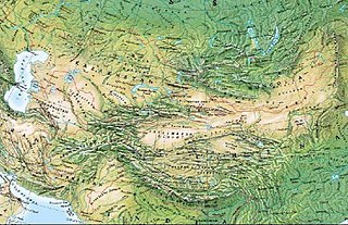
WThe Mountains of Central Asia are a biodiversity hot spot designated by Conservation International which covers several montane and alpine ecoregions of Central Asia, including those of the Pamir and Tian Shan ranges, and extending across portions of Afghanistan, China, Kazakhstan, Kyrgyzstan, Tajikistan, and Uzbekistan.
WPeter I Range, Peter the First Range or Peter the Great Range is a mountain range in Tajikistan, part of the Pamir Mountain System. The range takes its name from Peter the Great.
 W
WThe Rasht Valley is located in Tajikistan and composes a significant portion of the Region of Republican Subordination, including the six districts of Lakhsh, Rasht, Roghun, Tavildara, Tajikobod and Nurabad. Historically the Rasht Valley has been called Karotegin or Karategin. During the 1992-1997 Tajikistan Civil War, the region was a stronghold for forces opposed to the government of Emomalii Rahmon and became the site of numerous battles. Notably, four members of the United Nations Mission of Observers in Tajikistan were murdered in the Garm district in 1998.
WRushan Range is a mountain range in south-western Pamir in Tajikistan, trending in the south-westerly direction from Sarez Lake toward Khorog, between Gunt River to the south and Bartang River to the north. About 120 km long, it reaches its highest elevation of 6,083 m at Patkhor Peak.
WThe Sarikol Range is a mountain range in the Pamirs on the border of Tajikistan and the People's Republic of China.
WShakhdara Range is a mountain range in Tajikistan, part of the Pamir Mountain System.
 W
WThe Trans-Alay Range is the northernmost range of the Pamir Mountain System.
 W
WThe Vanj Range is a mountain range of Vanj district, Gorno-Badakhshan, Tajikistan.
WYazgulem Range is a mountain range of the western Pamir Mountains.