 W
WBeinn a' Chaorainn is a Scottish mountain situated in the heart of the Cairngorms range. It is quite a remote hill, being located roughly 19 kilometres south east of Aviemore and 14 kilometres north west of Braemar. The mountain stands on the border of the Moray and Aberdeenshire council areas. The hill's name used to be spelt as Beinn a' Chaoruinn, but the spelling of the word caorunn was altered to caorann by the Gaelic Orthographic Convention's attempts to standardise spelling.
 W
WBeinn a' Bhùird is a Munro in the Cairngorm mountain range of Scotland.
 W
WBeinn Bhreac is a twin-peaked Scottish mountain located above Glen Derry in the Cairngorm Mountains approximately 11 kilometres (7 mi) north-west of Braemar.
 W
WBeinn Bhrotain or Ben Vrottan is a Scottish mountain in the Cairngorms range, 18 kilometres west of Braemar in the county of Aberdeenshire.
 W
WBeinn Mheadhoin is a mountain in Scotland. By some counts it is the thirteenth-highest mountain of Great Britain. It lies in the very heart of the Cairngorm mountains, and is one of the most remote hills in the region.
 W
WBen Avon is a mountain in the Cairngorm mountains of Scotland. The highest point of the massif, known as Leabaidh an Dàimh Bhuidhe is classified as both a Munro and a Marilyn.
 W
WBen Macdui is the second highest mountain in Scotland after Ben Nevis, and the highest in the Cairngorms National Park. The summit elevation is 1,309 meters AMSL. Ben Macdui lies on the southern edge of the Cairn Gorm plateau, on the boundary between the historic counties of Aberdeenshire and Banffshire.
 W
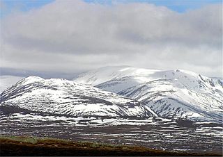
WBraeriach is the third-highest mountain in the British Isles, surpassed only by Ben Nevis and Ben Macdui. It is the highest point in the western massif of the Cairngorms, separated from the central section by the pass of the Lairig Ghru. The summit has a crescent shape, with several corries. In the north-facing corrie of Garbh Coire Mor the snow has completely melted just six times in the last century: 1933, 1959, 1996, 2003, 2006 and 2017 and the patches that linger there are the longest-lying snow patches in Scotland and more generally, in the entire British Isles.
 W
WBynack More is a Scottish Mountain that is situated in the Cairngorms range, 16 kilometres east-south-east of the town of Aviemore in the Highland region.
 W
WCairn Gorm (Cairngorm) is a mountain in the Scottish Highlands overlooking Strathspey and the town of Aviemore. Cairn Gorm has a summit elevation of 1,245 metres (4,084 feet) AMSL and is the seventh-highest mountain in both the United Kingdom and the British Isles. Cairn Gorm gives its name to the mountain range and the National Park of which it is a part, The Cairngorms, despite that it is neither the highest nor the most prominent mountain in the range. These mountains were historically known as Am Monadh Ruadh rather than the Cairngorms. The domed summit of Cairn Gorm is one of the most readily identifiable mountains in the view from Aviemore.
 W
WCairn Toul is the fourth highest mountain in Scotland, The United Kingdom, and The British Isles, after Ben Nevis, Ben Macdui and Braeriach. The summit elevation is 1,291 metres AMSL. It is the second highest point in the western massif of the Cairngorms, linked by a bealach at about 1125 m above sea level to Braeriach.
 W
WCàrn a' Mhàim is a Scottish mountain situated in the inner part of the Cairngorms range, some 15 kilometres west of Braemar in the county of Aberdeenshire.
 W
WDerry Cairngorm is a Scottish mountain in the Cairngorms range, 14 kilometres (8.7 mi) north west of Braemar in the county of Aberdeenshire.
 W
WThe Devil's Point is a mountain in the Cairngorms of Scotland, lying to the west of the Lairig Ghru pass. The Gaelic name means "Penis of the Demon". The English name is a result of a visit to the area by Queen Victoria. She asked her local ghillie, John Brown, to translate the name; to avoid embarrassment he gave a euphemistic answer.
 W
WMeall a' Bhuachaille is a mountain in the Cairngorms in Scotland. It is situated 10 km east of Aviemore, to the north of Loch Morlich and Glenmore Forest.
 W
WMonadh Mòr is a mountain in the Cairngorms region of the Highlands of Scotland.
 W
WSgòr an Lochain Uaine is a mountain in the Cairngorms, Scotland. By some counts it is the fifth-highest mountain in Scotland. It is the third-highest point in the western massif of the Cairngorms, lying between Braeriach and Cairn Toul on the western side of the pass of the Lairig Ghru. It was promoted to Munro status by the Scottish Mountaineering Club's 1997 revision of the tables.
 W
WSgòr Gaoith is a mountain in the western massif of the Cairngorms, and is separated from the Braeriach massif by the broad valley of Glen Einich. The second-highest summit of the mountain is Sgoran Dubh Mòr, which lies 1.3 km away due NNE along the summit ridge. The eastern side of Sgòr Gaoith is girded by steep cliffs which plunge down to Loch Einich; the western side is composed of heather slopes and a number of shallow corries.