 W
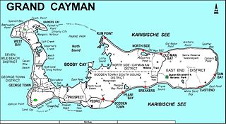
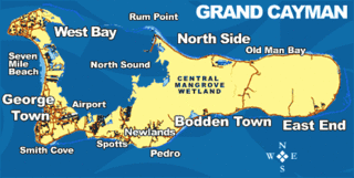
WGrand Cayman is the largest of the three Cayman Islands and the location of the territory's capital, George Town. In relation to the other two Cayman Islands, it is approximately 75 miles (121 km) southwest of Little Cayman and 90 miles (145 km) southwest of Cayman Brac.
 W
WBodden Town, Grand Cayman, is the former capital of the Cayman Islands and centre of the largest district in the Cayman Islands. It is situated on a natural harbour and a coral reef. The first settlement was named after a government leader, William Bodden. Once ravaged by pirates, this village is known for its remains of a 4 mi (6 km) wall and cannon. Bodden Town has a population of 16,325. Its top attractions include the Mission House, which features the lifestyle of early Caymanian settlers. Bodden Town is also considered the fastest growing district in the islands in terms of resident population.
 W
WThe Mission House is a historic house located in Bodden Town, Grand Cayman. The house rose to prominence in the 1800s and became known as the "Mission House" because of early missionaries, teachers and families who lived there while establishing a Presbyterian church and school in Bodden Town.
 W
WThe Botanic Park and Salina Reserve Important Bird Area comprises two separate sites on Grand Cayman, one of the Cayman Islands, a British Overseas Territory in the Caribbean Sea.
 W
WCaymanite at its type area is an uncommon variety of dolomite, also known as dolostone, originally reported from locations in the Miocene Cayman Formation in the Cayman Islands: the Bluff in Cayman Brac and the East End on Grand Cayman.
 W
WThe Central Manrove Wetland is a large area of mangrove dominated wetland on Grand Cayman, one of the Cayman Islands, a British Overseas Territory in the Caribbean Sea. It is one of the territory's Important Bird Areas (IBAs).
 W
WThe East End Light is a lighthouse located at the east end of Grand Cayman island in the Cayman Islands. The lighthouse is the centerpiece of East End Lighthouse Park, managed by the National Trust for the Cayman Islands; the first navigational aid on the site was the first lighthouse in the Cayman Islands.
 W
WEast End is a village and one of the five districts of the Cayman Islands. Located on south-east coast of Grand Cayman, in 2018 it had a population of 2,395.
WThe Eastern Dry Forest lies at the eastern end of Grand Cayman, one of the Cayman Islands, a British Overseas Territory in the Caribbean Sea. It is one of the territory's Important Bird Areas (IBAs).
WFrank Sound Forest lies near the southern coast of the East End district of Grand Cayman, one of the Cayman Islands, a British Overseas Territory in the Caribbean Sea. It is one of the territory's Important Bird Areas (IBAs).
WFranklin's Forest lies near the centre of the East End distinct of Grand Cayman, one of the Cayman Islands, a British Overseas Territory in the Caribbean Sea. It is one of the territory's Important Bird Areas (IBAs).
 W
WHell is a group of short, black, limestone formations located in Grand Cayman, Cayman Islands. Located in West Bay, it is roughly the size of half a football field. Visitors are not permitted to walk on the limestone formations but viewing platforms are provided.
WMalportas Pond is a salt-water pond on the north coast of Grand Cayman, Cayman Islands, near North Side village. It has an area of 44 hectares or 52 hectares, and like the nearby Rock and Point ponds, it is an important area for breeding waterfowl. Local farmer Willie Ebanks introduced West Indian whistling-ducks on the pond in 1990, and it also has populations of heron, egrets, moorhens, and coots. It forms part of the Central Mangrove Wetland Important Bird Area, identified as such by BirdLife International because it supports populations of waterbirds.
WMastic Reserve lies at the eastern end of the North Side of Grand Cayman, one of the Cayman Islands, a British Overseas Territory in the Caribbean Sea. It, with the associated Mastic Trail, is managed by the National Trust for the Cayman Islands and is one of the territory's Important Bird Areas (IBAs). It is named after the yellow mastic and black mastic trees which occur in the reserve.
WNorth Side is one of the seven districts of the Cayman Islands. Located on the northern coast of Grand Cayman, in 2010 it had a population of 1,437. They have an association football team called the North Side FC.
 W
WQueen Elizabeth II Botanic Park is a non-profit outdoor garden and wildlife facility located in the North Side District of Grand Cayman Island in the British West Indies. The park is owned jointly by the Cayman Islands Government and the National Trust for the Cayman Islands, a group dedicated to preserving natural environments and places of historic significance in the Cayman Islands. Opened in 1994 with only the Woodland Trail completed, the park now also contains the Floral Colour Garden, a Cayman Heritage Garden, a lake, an orchid boardwalk exhibit, and a Blue Iguana Habitat. Also inside the park is a gift shop and a visitor's interpretive center, the starting point from which visitors can enter the Woodland Trail and other garden grounds.
 W
WThe Watler Cemetery is a historic cemetery located in Prospect, Grand Cayman. It was donated to the National Trust for the Cayman Islands by the Watler family in 1991.
WWest Bay is a district located on the west side of Grand Cayman Island in the British West Indies. The population is 15,436.