 W
WBeaufortain is a valley in the Savoie department in the Rhône-Alpes region in south-eastern France. It extends around the commune of Beaufort.
 W
WThe Grésivaudan is a valley of the French Alps, situated mostly in the Isère. Etymologically, Graisivaudan comes from roots meaning "Grenoble" (Gratianopolis) and "valley". It comprises the alluvial plain of the river Isère from Grenoble to the confluence of the Arc; or, more recently, the entire valley of the Isère from Tullins to Albertville. The stretch from Tullins to Grenoble is the Bas-Grésivaudan and that between Grenoble and Albertville is the Haut-Grésivaudan.
 W
WThe Lavedan, or occasionally vallées des Gaves, denotes a mountainous natural region of France, located at the heart of the Pyrénées, and forms a group of valleys upstream of Lourdes.
 W
WThe Loire Valley is listed UNESCO World Heritage site since 30 November 2000 under the reference 933bis. The justification for the inscription of the territory is based on several criteria: its architectural heritage which includes the Châteaux of the Loire, its exceptional cultural landscape and its cultural monuments, witnesses of the Renaissance and the century Enlightenment.
 W
WThe Loire Valley, spanning 280 kilometres (170 mi), is located in the middle stretch of the Loire river in central France, in both the administrative regions Pays de la Loire and Centre-Val de Loire. The area of the Loire Valley comprises about 800 square kilometres (310 sq mi). It is referred to as the Cradle of the French and the Garden of France due to the abundance of vineyards, fruit orchards, and artichoke, and asparagus fields, which line the banks of the river. Notable for its historic towns, architecture, and wines, the valley has been inhabited since the Middle Palaeolithic period. In 2000, UNESCO added the central part of the Loire River valley to its list of World Heritage Sites.
 W
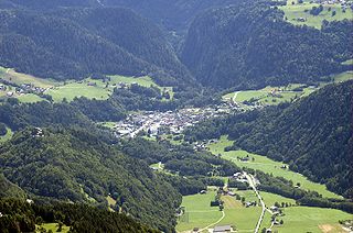
WMaurienne is one of the provinces of Savoy, corresponding to the arrondissement of Saint-Jean-de-Maurienne in France. It is also the original name of the capital of the province, now Saint-Jean-de-Maurienne.
 W
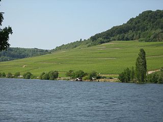
WThe Moselle Valley is a region in north-eastern France, south-western Germany, and eastern Luxembourg, centred on the river valley formed by the Moselle. The Moselle runs through, and along the borders of, the three countries, and drains a fourth, Belgium.
 W
WL'Oisans is a region in the French Alps, located in the départements of l'Isère and Hautes-Alpes, and corresponding to the drainage basin of the River Romanche and its tributaries. Between Livet-et-Gavet and Le Bourg-d'Oisans, the Romanche forms a deep gorge.
 W
WThe Ossau Valley is a valley of the French Pyrénées, in the Pyrénées-Atlantiques département.
 W
WThe Tarentaise Valley is a valley of the Isère River in the heart of the French Alps, located in the Savoy region of France. The valley is named for the ancient town of Darantasia, the capital of the pre-Roman Centrones tribe.
 W
WThe Ubaye Valley is an area in the Alpes de Haute-Provence département, in the French Alps, having approximately 7,700 residents. Its residents are called Ubayens. Its principal town is the sous-préfecture of Barcelonnette.
 W
WVal d'Enfer, is a valley cut into the rock by water erosion. It is located near the village of Les Baux-de-Provence in Provence south eastern France and it takes its name from the strangeness of its white limestone rock formations.
 W
WThe vallée d'Aure is located in the French Pyrenees, in the Hautes-Pyrénées department, in the region of Midi-Pyrénées.
 W
WVallée de Chevreuse is the valley of the Yvette River in the Yvelines and Essonne departments.
 W
WThe Vallée de la Clarée is a scenic valley in the French Alps near to Montgenèvre, Briançon and the French-Italian border. The Clarée river runs through the valley.
 W
WThe Vallée des Merveilles, also known in Italian as the Valle delle Meraviglie, is a part of the Mercantour National Park in southern France. It holds the largest quantity of open-air Bronze Age petroglyphs in Europe, after Val Camonica in Italy, and is given special note for the area's inclusion for the European Diploma of Protected Areas.
 W
WThe Vallée des Rouets is a part of the valley of the Durolle river, principally situated on the land of Thiers, in the French department of Puy-de-Dôme in the Auvergne-Rhône-Alpes region. The area is known for its long artisanal past, as the inhabitants have made use of the locomotive power of the Durolle River since the Middle Ages. The beginning of the 20th century marked the closure of most of the water-powered mills in the valley in favor of the production of cutlery, mainly situated in the Vallée des Usines, located downstream.