 W
WA valley is a low area between hills or mountains typically with a river running through it. In geology, a valley or dale is a depression that is longer than it is wide. The terms U-shaped and V-shaped are descriptive terms of geography to characterize the form of valleys. Most valleys belong to one of these two main types or a mixture of them, at least with respect to the cross section of the slopes or hillsides.
 W
WAn arroyo, also called a wash, is a dry creek, stream bed or gulch that temporarily or seasonally fills and flows after sufficient rain. Flash floods are common in arroyos following thunderstorms.
 W
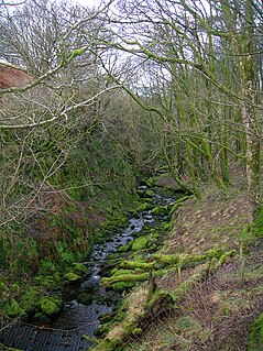
WIn physical geography, a dell is a small secluded hollow, grassy, park-like, usually partially-wooded valley. The word "dell" comes from the Old English word dell, which is related to the Old English word dæl, modern 'dale'. Dells in literature are often portrayed as pleasant safe havens. The term is sometimes used interchangeably with dingle, although this specifically refers to deep ravines or hollows that are embowered with trees. The terms have also been combined to form examples of tautological placenames in Dingle Dell, Kent, and Dingle Dell Reserve, Auckland.
 W
WA dry valley may develop on many kinds of permeable rock, such as limestone and chalk, or sandy terrains that do not regularly sustain surface water flow. Such valleys do not hold surface water because it sinks into the permeable bedrock.
 W
WA glen is a valley, typically one that is long and bounded by gently sloped concave sides, unlike a ravine, which is deep and bounded by steep slopes. Whittow defines it as a "Scottish term for a deep valley in the Highlands" that is "narrower than a strath". The word is Goidelic in origin: gleann in Irish and Scottish Gaelic, glion in Manx. The designation "glen" also occurs often in place names.
 W
WIn xeric lands, a gulch is a deep V-shaped valley formed by erosion. It may contain a small stream or dry creek bed and is usually larger in size than a gully. Sudden intense rainfall upstream may produce flash floods in the bed of the gulch.
 W
WA gully is a landform created by running water, eroding sharply into soil, typically on a hillside. Gullies resemble large ditches or small valleys, but are metres to tens of metres in depth and width. When the gully formation is in process, the water flow rate can be substantial, causing a significant deep cutting action into soil.
 W
WA high valley or high-level valley is a valley in the upper third of a mountain range. More loosely it can refer to any mountain valley.
 W
WA longitudinal valley is an elongated valley found between two almost-parallel mountain chains in geologically young fold mountains, such as the Alps, Carpathians, Andes, or the highlands of Central Asia. They are often occupied and shaped by a subsequent stream. The term is frequently used if a mountain range also has prominent transverse valleys, where rivers cut through the mountain chains in so-called water gaps.
 W
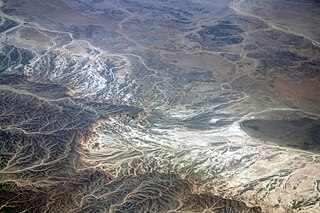
WThe Pamir Mountains are a mountain range between Central Asia, South Asia, and East Asia, at the junction of the Himalayas with the Tian Shan, Karakoram, Kunlun,and Hindu Kush. They are among the world's highest mountains.
 W
WA strath is a large valley, typically a river valley that is wide and shallow.
 W
WTang Valley is one of the four valleys of Bumthang District, Bhutan.
 W
WA transverse valley is a valley which cuts at right angles across a ridge or, in mountainous terrain a valley that generally runs at right angles to the line of the main mountain chain or crest. Its geomorphological counterpart is the longitudinal valley.
 W
WA tunnel valley is a U-shaped valley originally cut under the glacial ice near the margin of continental ice sheets such as that now covering Antarctica and formerly covering portions of all continents during past glacial ages. They can be as long as 100 km (62 mi), 4 km (2.5 mi) wide, and 400 m (1,300 ft) deep.
 W
WU-shaped valleys, trough valleys or glacial troughs, are formed by the process of glaciation. They are characteristic of mountain glaciation in particular. They have a characteristic U shape, with steep, straight sides and a flat or rounded bottom. Glaciated valleys are formed when a glacier travels across and down a slope, carving the valley by the action of scouring. When the ice recedes or thaws, the valley remains, often littered with small boulders that were transported within the ice, called glacial till or glacial erratic.
 W
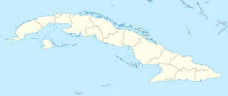
WValle de los Ingenios, also named Valley de los Ingenios or Valley of the Sugar Mills, is a series of three interconnected valleys about 12 kilometres (7.5 mi) outside of Trinidad, Cuba. The three valleys, San Luis, Santa Rosa, and Meyer, were a centre for sugar production from the late 18th century until the late 19th century.
 W
WWadi, alternatively wād, North African Arabic Oued, is the Arabic term traditionally referring to a valley. In some instances, it may refer to a dry (ephemeral) riverbed that contains water only when heavy rain occurs.