 W
WA polder is a low-lying tract of land that forms an artificial hydrological entity, enclosed by embankments known as dikes. The three types of polder are:Land reclaimed from a body of water, such as a lake or the seabed Flood plains separated from the sea or river by a dike Marshes separated from the surrounding water by a dike and subsequently drained; these are also known as koogs, especially in Germany
 W
WCanvey Island is a civil parish and reclaimed island in the Thames estuary in Essex, England. It has an area of 7.12 square miles (18.44 km2) and a population of 38,170. It is separated from the mainland of south Essex by a network of creeks. Lying only just above sea level, it is prone to flooding at exceptional tides, but has nevertheless been inhabited since the Roman invasion of Britain.
 W
WThe Fens, also known as the Fenlands, is a coastal plain in eastern England. This naturally marshy region supports a rich ecology and numerous species, and helps absorb storms. Most of the fens were drained centuries ago, resulting in a flat, dry, low-lying agricultural region supported by a system of drainage channels and human-made rivers and automated pumping stations. There have been unintended consequences to this reclamation, as the land level has continued to sink and the dykes have been built higher to protect it from flooding.
 W
WHachirōgata or Hachirō Lagoon is a lake in Akita Prefecture in northern Japan. Its formal name is Lake Hachirō , but it is also called Hachirōgata Regulating Pond . At 4 meters below sea level, Hachirōgata is the lowest natural point in Japan.
 W
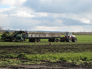
WThe Holland Marsh is a wetland and agricultural area in Ontario, Canada, about 50 kilometres (31 mi) north of Toronto. It lies entirely within the valley of the Holland River, stretching from the northern edge of the Oak Ridges Moraine near Schomberg to the river mouth at Cook's Bay, Lake Simcoe. In its entirety it comprises about 21,000 acres, with two distinct divisions. Historically it has simply been referred to as "the marsh".
 W
WDe Moeren (Dutch) or Les Moëres (French) are a marshy region in the Westhoek, politically divided between the French-Belgian border. At one time the area was inhabited by the Gallic people known as the Morini; they are believed to have lent their name to the territory.
 W
WMundy Pond is a pond in St. John's, Newfoundland and Labrador, Canada that runs along Mundy Pond Road. It has facilities such as a park and skatepark near its shore, with a trail around its shore.
 W
WNemunas Delta is the Lithuanian name for the Neman (Nemunas) River Delta, in Lithuania. Prior to post-World War II border changes, it was known in German as the Memel Niederung, as the Neman was for centuries called the Memel in German.
 W
WNew Orleans is a consolidated city-parish located along the Mississippi River in the southeastern region of the U.S. state of Louisiana. With an estimated population of 390,144 in 2019, it is the most populous city in Louisiana. Serving as a major port, New Orleans is considered an economic and commercial hub for the broader Gulf Coast region of the United States.
 W
WNordstrand (help·info) is a peninsula and former island in North Frisia on the North Sea coast of Germany. It is part of the Nordfriesland district in the federal state of Schleswig-Holstein. Its area is 50 km², and its population is 2,300. Nordstrand has two municipalities, Nordstrand and smaller Elisabeth-Sophien-Koog, which are part of the Amt Nordsee-Treene.
 W
WNowy Dwór Gdański County is a unit of territorial administration and local government (powiat) in Pomeranian Voivodeship, northern Poland, on the Baltic coast. It came into being on January 1, 1999, as a result of the Polish local government reforms passed in 1998. Its administrative seat and largest town is Nowy Dwór Gdański, which lies 36 kilometres (22 mi) south-east of the regional capital Gdańsk. The only other town in the county is Krynica Morska, lying 29 km (18 mi) north-east of Nowy Dwór Gdański, on the Vistula Spit.
 W
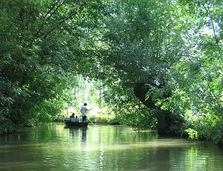
WThe Marais Poitevin or Poitevin Marsh is a large area of marshland in western France. The name means "Poitou's Marsh" or the "Marsh of the Poitou region". It is a remnant of what was the former Gulf of Poitou. The western zone near the sea is called the "dry marsh". It is used for farming and livestock breeding. The eastern zone, called the "wet marsh", is a maze of islets crisscrossed by picturesque canals, primarily now a tourist destination for boating. It is nicknamed The Green Venice.
 W
WThe Sacramento–San Joaquin River Delta, or California Delta, is an expansive inland river delta and estuary in Northern California. The Delta is formed at the western edge of the Central Valley by the confluence of the Sacramento and San Joaquin rivers and lies just east of where the rivers enter Suisun Bay. The Delta is recognized for protection by the California Bays and Estuaries Policy. Sacramento–San Joaquin Delta was designated a National Heritage Area on March 12, 2019. The city of Stockton is located on the San Joaquin River on the eastern edge of the delta. The total area of the Delta, including both land and water, is about 1,100 square miles (2,800 km2). Its population is around 500,000 residents.
 W
WSealand is a community in Flintshire and electoral ward, north-east Wales, on the edge of the Wirral peninsula. It is west of the city of Chester, England, and is part of the Deeside conurbation on the Wales-England border. At the 2001 Census, it had a population of 2,746, increasing to 2,996 at the 2011 census.
 W
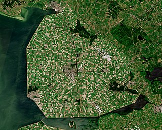
WSöderfjärden is a polder in Ostrobothnia, western Finland, 10 kilometres south of the town of Vaasa. The plain is in an impact crater which was made at least some 640 million years old. The crater's diameter is 6.6 km and its maximum depth is 300 metres. It is filled with Cambrian sandstones leaving only the outer rim visible. There is also a central uplift, which is buried. After rising from the sea due to post-glacial rebound, Söderfjärden was a wetland but was later drained with help of a pump station. It is currently cultivated and is clearly visible from air as a large circular field. This makes Söderfjärden unique among the other impact structures in Finland which are at least partially below sea level.
 W
WSunk Island is a Crown Estate village and civil parish in the East Riding of Yorkshire, England. It lies 3 1⁄2 miles (6 km) south of Ottringham and 1 mile (1.6 km) to the north of the Humber Estuary. The Greenwich Meridian passes through the east of the parish.
 W
WTraeth Mawr is a polder near Porthmadog in Gwynedd in Wales. The area was formerly the large tidal estuary of the Afon Glaslyn. It was created after large-scale land reclamation occurred in the late 18th century and the early 19th century. A large embankment, called the Cob, separates the area from the sea and carries a road and railway line.