 W
WBewani Mountains is a mountain range in northwestern Papua New Guinea. Together with the Torricelli Mountains and Prince Alexander Mountains it forms the North Coastal Range of Papua New Guinea. Highest point of the mountains is at 1,960 m.
 W
WDaikakuji Seamount is a seamount and the southwesternmost volcanic feature in the Hawaiian Emperor chain bend area.
 W
WThe French Frigate Shoals is the largest atoll in the Northwestern Hawaiian Islands. Its name commemorates French explorer Jean-François de La Pérouse, who nearly lost two frigates when attempting to navigate the shoals. It consists of a 20-mile (32 km) long crescent-shaped reef, twelve sandbars, and the 120-foot (37 m) high La Perouse Pinnacle, the only remnant of its volcanic origins. The total land area of the islets is 61.508 acres (24.891 ha). Total coral reef area of the shoals is over 232,000 acres (94,000 ha). Tern Island, with an area of 26.014 acres (10.527 ha), has a landing strip and permanent habitations for a small number of people. It is maintained as a field station in the Hawaiian Islands National Wildlife Refuge by the United States Fish and Wildlife Service. The French Frigate Shoals are about 487 nautical miles northwest of Honolulu.
 W
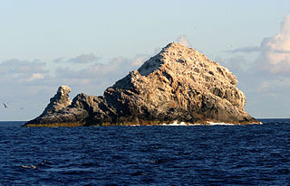
WThe Gardner Pinnacles are two barren rock outcrops surrounded by a reef and located in the Northwestern Hawaiian Islands at 24°59′56″N 167°59′58″W.
WKoko Guyot is a 48.1-million-year-old guyot, a type of underwater volcano with a flat top, which lies near the southern end of the Emperor seamounts, about 200 km (124 mi) north of the "bend" in the volcanic Hawaiian-Emperor seamount chain. Pillow lava has been sampled on the north west flank of Koko Seamount, and the oldest dated lava is 40 million years old. Seismic studies indicate that it is built on a 9 km (6 mi) thick portion of the Pacific Plate. The oldest rock from the north side of Koko Seamount is dated at 52.6 and the south side of Koko at 50.4 million years ago. To the southeast of the bend is Kimmei Seamount at 47.9 million years ago and southeast of it, Daikakuji at 46.7.
 W
WKure Atoll or Ocean Island is an atoll in the Pacific Ocean 48 nautical miles west-northwest of Midway Atoll in the Northwestern Hawaiian Islands at 28°25′N 178°20′W. The only land of significant size is called Green Island and is a habitat for hundreds of thousands of seabirds. A short, unused and unmaintained runway and a portion of one building, both from a former United States Coast Guard LORAN station, are located on the island. Politically, it is part of Hawaii, although separated from the rest of the state by Midway, which is a separate unorganized territory. Green Island, in addition to being the nesting grounds of tens of thousands of seabirds, has recorded several vagrant terrestrial birds including snow bunting, eyebrowed thrush, brambling, olive-backed pipit, black kite, Steller's sea eagle and Chinese sparrowhawk. It is currently managed as a Wildlife Bird Sanctuary by the State of Hawaii's Department of Land and Natural Resource--Division of Forestry and Wildlife as one of the co-trustees of Papahānaumokuākea Marine National Monument with support from Kure Atoll Conservancy.
 W
WLaysan, located 808 nautical miles northwest of Honolulu at N25° 42' 14" W171° 44' 04", is one of the Northwestern Hawaiian Islands. It comprises one land mass of 1,016 acres (4.11 km2), about 1 by 1 1⁄2 miles in size. It is an atoll of sorts, although the land completely surrounds a shallow central lake some 8 feet (2.4 m) above sea level that has a salinity approximately three times greater than the ocean. Laysan's Hawaiian name of Kauō means egg.
 W
WLisianski Island is one of the Northwestern Hawaiian Islands, with a land area of 384.425 acres (155.571 ha) and a maximum elevation of 40 feet (12 m) above sea level. It is a low, flat sand and coral island about 905 nautical miles (1,676 km) northwest of Honolulu. The island is surrounded by reefs and shoals, including the extensive Neva Shoals. Access to the island is limited by helicopter or by boat to a narrow sandy inlet on the southeastern side of the island.
 W
WMaro Reef is a largely submerged coral atoll located in the Northwestern Hawaiian Islands. It was discovered in 1820 by Captain Joseph Allen of the ship Maro, after whose ship the reef was named. With a total area of 747 square miles (1,935 km2), it is the largest coral reef in the Northwestern Hawaiian Islands. It contains 37 species of stony coral. Unlike most atolls, the coral extends out from the center like spokes on a wheel. Located about 850 miles northwest of Honolulu, Hawaii, Maro Reef contains about 1 acre (4,000 m2) of dry land which itself can be submerged depending on the tides. Some scientists believe that it "may be on the verge of drowning" because the reefs are detached and are vulnerable to strong storm waves.
 W
WMidway Atoll is a 2.4-square-mile (6.2 km2) atoll in the North Pacific Ocean at 28°12′N 177°21′W. Midway Atoll is an unorganized, unincorporated territory of the United States.
 W
WNecker Island is a small island in the Northwestern Hawaiian Islands. It is located at 23°34′30″N 164°42′01″W in the Pacific Ocean, 155 miles northwest of Nihoa and 8 miles north of the Tropic of Cancer. It contains important prehistoric archaeological sites of the Hawaiian culture and is part of the Hawaiian Islands National Wildlife Refuge within the Northwestern Hawaiian Islands National Monument.
 W
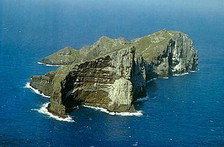
WNihoa, also known as Bird Island or Moku Manu, is the tallest of ten islands and atolls in the uninhabited Northwestern Hawaiian Islands (NWHI). The island is located at the southern end of the NWHI chain, 296 km (160 nmi) southeast of Necker Island. Nihoa is the closest NWHI in proximity to the eight main windward Hawaiian Islands at approximately 240 km (130 nmi) northwest of the island of Kauaʻi. The island has two peaks, 272 m (892 ft) Miller's Peak in the west, and 259 m (850 ft) Tanager Peak in the east. Nihoa's area is about 171 acres (0.69 km2) and is surrounded by a 142,000-acre (57,000 ha) coral reef. Its jagged outline gives the island its name, Nīhoa, which is Hawaiian for "tooth".
WNintoku Seamount or Nintoku Guyot is a seamount and guyot in the Hawaiian-Emperor seamount chain. It is a large, irregularly shaped volcano that last erupted 66 million years ago. Three lava flows have been sampled at Nintoku Seamount; the flows are almost all alkalic (subaerial) lava. It is 56.2 million years old.
 W
WOtekaikea is an extinct genus of toothed whale closely related to Waipatia. It is known from the late Oligocene (Chattian) of New Zealand.
 W
WPalaeeudyptes is an extinct genus of large penguins, currently containing four accepted species. They were probably larger than almost all living penguins, with the smaller species being about the size of an emperor penguin and the largest ones having stood about 2 meters tall.
 W
WThe Pearl and Hermes Atoll is part of the Northwestern Hawaiian Islands, a group of small islands and atolls that form the farthest northwest portion of the Hawaiian island chain. The atoll consists of a variable number of flat and sandy islets, typically between five and seven. More were noted in historical sources but have since been lost to erosion and rising sea levels.
WYuryaku Seamount is a seamount and guyot (flat-topped) located northwest of Hawaii. It is located a little southwest of the V-shaped bend separating the Emperor Seamounts from the older Hawaiian islands, all of the Hawaiian-Emperor seamount chain in the North Pacific Ocean.