 W
WJuan de Fuca Channel is a submarine channel off the shore of Washington state, United States and the Strait of Juan de Fuca.
 W
WAn ocean current is a continuous, directed movement of sea water generated by a number of forces acting upon the water, including wind, the Coriolis effect, breaking waves, cabbeling, and temperature and salinity differences. Depth contours, shoreline configurations, and interactions with other currents influence a current's direction and strength. Ocean currents are primarily horizontal water movements.
 W
WThe Barents Sea Opening (BSO) is an oceanographic term for the Western Barents Sea, the sea area between Bear Island in the south of Svalbard and the northern extremity of Norway through which a water mass of Atlantic origin flows into the Arctic Ocean. The inflow of relative warm water into the Arctic Ocean occurs not only through the Barents Sea Opening, but also through Fram Strait which is much deeper. The internal energy entering the colder waters has an influence on the atmosphere and the sea ice above and therefore possibly on the global climate.
 W
WBoundary currents are ocean currents with dynamics determined by the presence of a coastline, and fall into two distinct categories: western boundary currents and eastern boundary currents.
 W
WFor other uses, see Costa Rica.
 W
WA current meter is oceanographic device for flow measurement by mechanical, tilt, acoustical or electrical means.
 W
WThe Fram Strait is the passage between Greenland and Svalbard, located roughly between 77°N and 81°N latitudes and centered on the prime meridian. The Greenland and Norwegian Seas lie south of Fram Strait, while the Nansen Basin of the Arctic Ocean lies to the north. Fram Strait is noted for being the only deep connection between the Arctic Ocean and the World Oceans. The dominant oceanographic features of the region are the West Spitsbergen Current on the east side of the strait and the East Greenland Current on the west.
 W
WFriendly Floatees are plastic rubber ducks marketed by The First Years, and made famous by the work of Curtis Ebbesmeyer, an oceanographer who models ocean currents on the basis of flotsam movements. Ebbesmeyer studied the movements of a consignment of 29,000 Friendly Floatees—yellow ducks, red beavers, blue turtles and green frogs—which were washed into the Pacific Ocean in 1992. Some of the toys landed along Pacific Ocean shores, such as Hawaii. Others traveled over 17,000 miles, floating over the site where the Titanic sank, and spent years frozen in Arctic ice to reach the U.S. Eastern Seaboard, British and Irish shores 15 years later in 2007.
 W
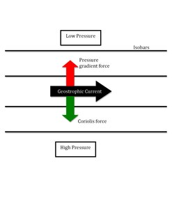
WA geostrophic current is an oceanic current in which the pressure gradient force is balanced by the Coriolis effect. The direction of geostrophic flow is parallel to the isobars, with the high pressure to the right of the flow in the Northern Hemisphere, and the high pressure to the left in the Southern Hemisphere. This concept is familiar from weather maps, whose isobars show the direction of geostrophic flow in the atmosphere. Geostrophic flow may be either barotropic or baroclinic. A geostrophic current may also be thought of as a rotating shallow water wave with a frequency of zero. The principle of geostrophy is useful to oceanographers because it allows them to infer ocean currents from measurements of the sea surface height or from vertical profiles of seawater density taken by ships or autonomous buoys. The major currents of the world's oceans, such as the Gulf Stream, the Kuroshio Current, the Agulhas Current, and the Antarctic Circumpolar Current, are all approximately in geostrophic balance and are examples of geostrophic currents.
 W
WThe Great South Australian Coastal Upwelling System is a seasonal upwelling system in the eastern Great Australian Bight, extending from Ceduna, South Australia, to Portland, Victoria, over a distance of about 800 kilometres (500 mi). Upwelling events occur in the austral summer when seasonal winds blow from the southeast. These winds blow parallel to the shoreline at certain areas of the coast, which forces coastal waters offshore via Ekman transport and draws up cold, nutrient-rich waters from the ocean floor.
 W
WThis list of rogue waves compiles incidents of known and likely rogue waves – also known as freak waves, monster waves, killer waves, and extreme waves. These are dangerous and rare ocean surface waves that unexpectedly reach at least twice the height of the tallest waves around them, and are often described by witnesses as "walls of water". They occur in deep water, usually far out at sea, and are a threat even to capital ships and ocean liners.
 W
WMoby-Duck: The True Story of 28,800 Bath Toys Lost at Sea and of the Beachcombers, Oceanographers, Environmentalists, and Fools, Including the Author, Who Went in Search of Them is a book by Donovan Hohn concerning 28,800 plastic ducks and other toys, known as the Friendly Floatees, which were washed overboard from a container ship in the Pacific Ocean on 10 January 1992 and have subsequently been found on beaches around the world and used by oceanographers including Curtis Ebbesmeyer to trace ocean currents.
 W
WOcean acoustic tomography is a technique used to measure temperatures and currents over large regions of the ocean. On ocean basin scales, this technique is also known as acoustic thermometry. The technique relies on precisely measuring the time it takes sound signals to travel between two instruments, one an acoustic source and one a receiver, separated by ranges of 100–5000 km. If the locations of the instruments are known precisely, the measurement of time-of-flight can be used to infer the speed of sound, averaged over the acoustic path. Changes in the speed of sound are primarily caused by changes in the temperature of the ocean, hence the measurement of the travel times is equivalent to a measurement of temperature. A 1 °C change in temperature corresponds to about 4 m/s change in sound speed. An oceanographic experiment employing tomography typically uses several source-receiver pairs in a moored array that measures an area of ocean.
WRogue waves are unusually large, unexpected and suddenly appearing surface waves that can be extremely dangerous, even to large ships such as ocean liners.
 W
WA rotor current meter (RCM) is a mechanical current meter, an oceanographic device deployed within an oceanographic mooring measuring the flow within the world oceans to learn more about ocean currents. Many RCMs have been replaced by instruments measuring the flow by hydroacoustics, the so-called Acoustic Doppler Current Profilers. However, for instance in Fram Strait, the Alfred Wegener Institute still uses RCMs for long-term monitoring the inflow into the Arctic Ocean.
 W
WA turbidity current is most typically an underwater current of usually rapidly moving, sediment-laden water moving down a slope; although current research (2018) indicates that water-saturated sediment may be the primary actor in the process. Turbidity currents can also occur in other fluids besides water.
 W
WA warm core ring is a type of mesoscale eddy which breaks off from an ocean current, e.g. the Gulf Stream or the Kuroshio Current. The ring is an independent circulatory system of warm water which can persist for several months. The rest of this article will use the Gulf Stream by way of an example but these mesoscale eddies also form in most powerful ocean currents, such as the Kuroshio or Agulhas currents.