 W
WAstrolabe Reef is near Motiti Island, 20 kilometres NE of Tauranga, off the Bay of Plenty coast in New Zealand. The reef, which breaks the water surface at low tide, is a renowned scuba diving spot that drops off to 37 metres (121 ft) in different parts. The reef was named by Jules Dumont d'Urville after his ship Astrolabe, when it nearly ran aground there on 16 February 1827.
 W
WThe Bay of Plenty is a region of New Zealand, situated around a bight of the same name in the northern coast of the North Island. The bight stretches 260 km from the Coromandel Peninsula in the west to Cape Runaway in the east. The Bay of Plenty Region, governed by the Bay of Plenty Regional Council, incorporates several large islands in the bay, in addition to the mainland area. Called Te Moana-a-Toi in the Māori language after Toi, an early ancestor, the name 'Bay of Plenty' was bestowed by James Cook in 1769 when he noticed the abundant food supplies at several Māori villages there, in stark contrast to observations he had made earlier in Poverty Bay.
 W
WFrying Pan Lake is the world's largest hot spring. It is located in the Echo Crater of the Waimangu Volcanic Rift Valley, New Zealand and its acidic water maintains a temperature of about 50–60 °C (122–140 °F). The Lake covers 38,000 square meters in part of the volcanic crater and the shallow lake is only 18 feet deep, but at vents, it can go down to 60 feet.
 W
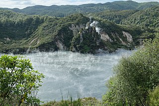
WInferno Crater Lake is a large hot spring located in the Waimangu Volcanic Rift Valley on the North Island of New Zealand, and the largest geyser-like feature in the world. The actual geyser is not visible, as it plays underwater at the bottom of the lake, however, fumaroles are visible on the lake's shore and the rock wall behind it.
 W
WThe Kaimai Range is a mountain range in the North Island of New Zealand. It is part of a series of ranges, with the Coromandel Range to the north and the Mamaku Ranges to the south. The Kaimai Range separates the Waikato in the west from the Bay of Plenty in the east.
 W
WMount Maunganui is a major residential, commercial and industrial suburb of the Tauranga metropolitan area, located on a peninsula to the north-east of Tauranga's city centre. It was an independent town from Tauranga until the completion of the Tauranga Harbour Bridge in 1988, which connects Mount Maunganui to Tauranga's central business district.
 W
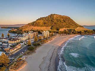
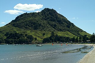
WMount Maunganui, or Mauao, commonly known by locals as The Mount, is an extinct volcanic cone at the end of a peninsula and the town of Mount Maunganui, by the eastern entrance to the Tauranga Harbour in New Zealand. It is considered very important and tapu (sacred) by the local Māori iwi, featuring extensively in local mythology. It is also of significant historical value. The summit is 232 metres above sea level.
 W
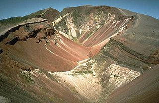
WMount Tarawera is a volcano on the North Island of New Zealand. Located 24 kilometres southeast of Rotorua, it consists of a series of rhyolitic lava domes that were fissured down the middle by an explosive basaltic eruption in 1886. This eruption was one of New Zealand's largest historical eruptions, and killed an estimated 120 people. The fissures run for about 17 kilometres northeast-southwest.
 W
WMoutohora Island or Whale Island is a small uninhabited island located off the Bay of Plenty coast of New Zealand's North Island, about 9 kilometres (5.6 mi) north of the town of Whakatane. The 1.43 km2 (0.55 sq mi) island is a remnant of a complex volcano which has eroded, leaving two peaks. This is still an area of volcanic activity and there are hot springs on the island in Sulphur Valley, McEwans Bay, and Sulphur Bay.
 W
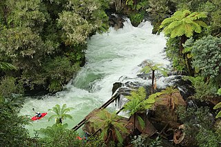
WOkere Falls is a small town located 21 km from Rotorua on SH 33 between Rotorua and Tauranga on the North Island of New Zealand. The town is situated on the shore of the Okere Inlet of Lake Rotoiti, from which the Kaituna River flows north towards the Bay of Plenty.
 W
WThe Pink Terrace, or Te Otukapuarangi in Māori, and the White Terrace, also known as Te Tarata, were natural wonders of New Zealand. They were reportedly the largest silica sinter deposits on earth. Until recently, they were lost and thought destroyed in the 1886 eruption of Mount Tarawera, while new hydrothermal features formed to the south-west i.e. Waimangu Volcanic Rift Valley.
 W
WPohutu Geyser is a geyser in the Whakarewarewa Thermal Valley, Rotorua, in the North Island of New Zealand. Pohutu means "big splash" or "explosion".
 W
WTarawera Falls is a 65 m high waterfall on the Tarawera River in the Bay of Plenty region in New Zealand's North Island.
 W
WTe Paepae o Aotea, also known the Volkner Rocks, are a group of andesitic rock stacks and pinnacles located 5 kilometres (3.1 mi) northwest of Whakaari/White Island in New Zealand's Bay of Plenty. They reach 113 metres above sea level, while the saddle separating them from Whakaari/White Island is over 200 metres deep.
 W
WThe Waimangu Geyser, located near Rotorua in New Zealand, was for a time the most powerful geyser in the world.
 W
WThe Waimangu Volcanic Rift Valley is the hydrothermal system created on 10 June 1886 by the volcanic eruption of Mount Tarawera, on the North Island of New Zealand. It encompasses Lake Rotomahana, the site of the Pink and White Terraces, as well as the location of the Waimangu Geyser, which was active from 1900 to 1904. The area has been increasingly accessible as a tourist attraction and contains Frying Pan Lake, which is the largest hot spring in the world, and the steaming and usually pale blue Inferno Crater Lake, the largest geyser-like feature in the world although the geyser itself cannot be seen since it plays at the bottom of the lake.
 W
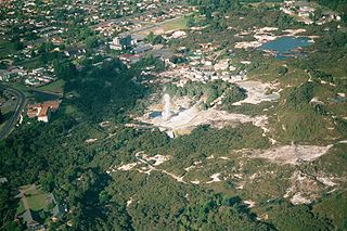
WWhakarewarewa is a Rotorua semi-rural geothermal area in the Taupo Volcanic Zone of New Zealand. This was the site of the Māori fortress of Te Puia, first occupied around 1325, and known as an impenetrable stronghold never taken in battle. Māori have lived here ever since, taking full advantage of the geothermal activity in the valley for heating and cooking.