 W
WThe Arzberg is a hill in Bavaria, Germany.
WBuchberg is a mountain of Bavaria, Germany.
WThe Dillberg is a hill in Bavaria, Germany.
 W
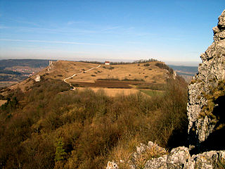
WThe Ehrenbürg is a double-peaked butte on the edge of the Franconian Jura in Bavaria, Germany. It is in the district of Forchheim in Upper Franconia, in the municipalities of Kirchehrenbach, Leutenbach and Wiesenthau. The north peak is the 513.9 m Walberla, the south peak the 531.7 m Rodenstein. The hill is popularly known as the Walberla.
WFriesener Warte is a hill in Bavaria, Germany.
WThe Geisberg is a hill in Bavaria, Germany.
 W
WGelber Berg is a mountain of Bavaria, Germany. The plateau was fortified during the 10th to 8th century BC, in the 6th century BC and during the Migration Period around 400-500 AD.
WGöschberg is a mountain of Bavaria, Germany.
 W
WThe Kleiner Kulm is a mountain in Bavaria, Germany. The mountain has a height of 626 m and thereby is the highest point of the Franconian Switzerland. On top, there is a lookout tower of 11 metres, which gives a view over the surrounding landscape.
 W
WKordigast is a mountain of Bavaria, Germany.
WMoritzberg is a mountain of Bavaria, Germany. It is part of the Franconian Jura range.
WThe Neubürg is a hill in Bavaria, Germany.
WThe Ottenberg is a hill in the Franconian Jura in Bavaria, Germany.
 W
WThe Reisberg is a hill in Bavaria, Germany.
 W
WThe Staffelberg is a hill in Bavaria, Germany. It is part of the Franconian Switzerland and one of the most important landmarks in Franconia. First settlements date from the Neolithic. Romans, Celts and Franconians followed. During the La Tène period the Celtic oppidum of Menosgada was built on the plateau of the Staffelberg.
WThe Zipser Berg is a hill in the Franconian Jura in the German state of Bavaria.