 W
WCascada de Texolo is a waterfall of eastern Mexico. It is located 3 kilometres south of the town of Xico, in the state of Veracruz, and approximately 19 kilometres from Xalapa city.
 W
WLaguna Catemaco is a freshwater lake located at the center of the Sierra de Los Tuxtlas in south central Veracruz near the city of Catemaco, in east central Mexico.
 W
WCofre de Perote, also known by its Nahuatl names Naupa-Tecutépetl and Nauhcampatépetl, both meaning something like "Place of Four Mountain" or "Mountain of the Lord of Four Places", is an inactive volcano located in the Mexican state of Veracruz, at the point where the Trans-Mexican Volcanic Belt, home to all of Mexico's highest peaks, joins the Sierra Madre Oriental. With an elevation of 4,282 metres (14,049 ft) above sea level, Cofre de Perote is Mexico's eighth highest mountain summit.
 W
WEyipantla Falls is a waterfall located in the Los Tuxtlas region of southern Veracruz in Mexico. It is forty meters wide and fifty meters tall and is the largest and most important waterfall in the region.
 W
WGran Glaciar Norte is the largest ice cap and firn field in México. It is located on Pico de Orizaba which is the highest point in Mexico. It contains nine named glaciers, including seven outlet glaciers, and a mountain niche glacier. The elevation of these glaciers range from near 5,610 m (18,410 ft) to 4,700 m (15,400 ft).
 W
WThe Gulf Coastal Plain extends around the Gulf of Mexico in the Southern United States and eastern Mexico.
 W
WThe Gulf of Mexico is an ocean basin and a marginal sea of the Atlantic Ocean, largely surrounded by the North American continent. It is bounded on the northeast, north and northwest by the Gulf Coast of the United States, on the southwest and south by the Mexican states of Tamaulipas, Veracruz, Tabasco, Campeche, Yucatan, and Quintana Roo, and on the southeast by Cuba. The US states of Texas, Louisiana, Mississippi, Alabama, and Florida border the Gulf on the north, which are often referred to as the "Third Coast", in comparison with the U.S. Atlantic and Pacific coasts.
 W
WThe Isthmus of Tehuantepec is an isthmus in Mexico. It represents the shortest distance between the Gulf of Mexico and the Pacific Ocean. Prior to the opening of the Panama Canal, it was a major shipping route known simply as the Tehuantepec Route. The name is taken from the town of Santo Domingo Tehuantepec in the state of Oaxaca; this was derived from the Nahuatl term tecuani-tepec.
 W
WLos Tuxtlas is a region in the south of the Mexican state of Veracruz. Politically it refers to four municipalities: Catemaco, San Andrés Tuxtla, Santiago Tuxtla and Hueyapan de Ocampo. It also refers to a high complex natural ecosystem, an isolated volcanic mountain range next to the Gulf of Mexico, home to the northern edge of tropical rainforest in the Americas. Although seriously deforested, most of it is under protection as the Los Tuxtlas Biosphere Reserve, which stretches over eight municipalities, centering on the four mentioned above. The area's early history was influenced by the Olmecs but had its own trajectory. In the colonial period, the population became a mix of indigenous, African and European. For all its history until the present, it has been rural and agricultural. Today one of its notable crops is tobacco. However, conservation efforts since the 1970s have promoted ecotourism, especially in Catemaco.
 W
WThe Oriental Basin, also known as the Libres-Oriental Basin, Oriental-Serdán Basin or San Juan Plains is an endorheic basin in east-central Mexico. It covers an area of 4,958.60 square kilometers, lying in the states of Puebla, Tlaxcala, and Veracruz.
 W
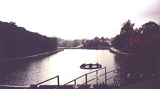
WPaseo de los Lagos is a lake and public path located in the city of Xalapa in Veracruz state in eastern Mexico. It was once the site of an ancient dam. The lake has a fresh-water spring and is surrounded by footpaths.
 W
WThe isolated San Martin Tuxtla volcano is a shield volcano which rises above the Gulf of Mexico. It has had eruptions in historical times. It occurs in the Tuxtla volcanic field in Veracruz, Mexico. Lavas from San Martin vary between basanite and alkali basalt. Locally the volcano is also known as Tiltépetl.
 W
WThe Sierra de Los Tuxtlas are a volcanic belt and mountain range along the southeastern Veracruz Gulf coast in Eastern Mexico. The Los Tuxtlas Biosphere Reserve includes the coastal and higher elevations of the Sierra de Los Tuxtlas.
 W
WThe Sierra Madre de Oaxaca is a mountain range in southern Mexico. It is primarily in the state of Oaxaca, and extends north into the states of Puebla and Veracruz.
 W
WSontecomapan Lagoon occupies an alluvial plain in the center of the Sierra de Los Tuxtlas, 18°33′N 95°1′W, in southeast central Veracruz, east central Mexico on the edge of the Gulf of Mexico. The laguna is part of the Catemaco municipio stretching from the Gulf of Mexico to the foothills of the San Martin Tuxtla Volcano and the Sierra Santa Marta.
 W
WThe Trans-Mexican Volcanic Belt, also known as the Transvolcanic Belt and locally as the Sierra Nevada, is a volcanic belt that covers central-southern Mexico. Several of its highest peaks have snow all year long, and during clear weather, they are visible to a large percentage of those who live on the many high plateaus from which these volcanoes rise.