 W
WHong Kong UNESCO Global Geopark, formerly Hong Kong National Geopark (香港國家地質公園), was inaugurated on 3 November 2009. It is a single entity of land area over 150 km2 across parts of the eastern and northeastern New Territories. On 18 September 2011, UNESCO listed the geopark as part of its Global Geoparks Network.
 W
WBasalt Island is an island of Hong Kong and administratively part of the Sai Kung District. Together with Wang Chau and Bluff Island, it forms the Ung Kong Group and is part of Hong Kong Global Geopark.
 W
WCentre Island or A Chau is a small uninhabited island of Hong Kong located in Tolo Harbour, in the northwestern part of the territory. Administratively, it is part of Tai Po District.
 W
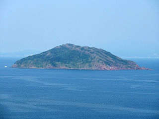
WPort Island or Chek Chau is an island of Hong Kong, under the administration of Tai Po District. It is located in Tolo Channel, in the northeastern New Territories. Its name literally means red island; after the sedimentary rocks rich in iron that form this island.
 W
WDouble Haven or Yan Chau Tong is a harbour enclosed by Double Island, Crescent Island and Crooked Island with north-eastern New Territories, Hong Kong. Parts of the haven fall within Yan Chau Tong Marine Park to protect the wildlife of the marine creatures. It is known for its scenery and natural environment, and for the calm seas from which its English name derives. Double Haven contains many deep red coloured rocks because of iron oxide.
 W
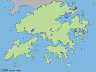
WDouble Island or Wong Wan Chau is an island located in the north-eastern part of Hong Kong. Administratively, it is part of North District.
 W
WHigh Island or Leung Shuen Wan Chau is a former island in the southeast of Sai Kung Peninsula, Hong Kong.
 W
WThe High Island Reservoir, located in the far south eastern part of the Sai Kung Peninsula, was opened in 1978 helping to alleviate water shortage problems in Hong Kong. Its water capacity is approximately 273 million cubic metres. The area it occupies was originally the Kwun Mun Channel (官門海峽), which separated High Island from the Sai Kung Peninsula.
 W
WKat O, also named Crooked Island, is an island in Northeast Hong Kong. Administratively, it is part of North District.
 W
WLai Chi Chong is a village and an area of Hong Kong, located on the southeastern shore of Tolo Channel, and on the northern shore of the Sai Kung Peninsula, in the Eastern New Territories. Administratively, it is part of Tai Po District.
 W
WMa Shi Chau (Chinese: 馬屎洲; Sidney Lau: Ma5Si2Jau1, literally "Horse Dung Island") is an island of Hong Kong, under the administration of Tai Po District. It is located in Tolo Harbour in the northeast New Territories (near Sam Mun Tsai). It is connected with another island, Yim Tin Tsai, by an isthmus traversable at low tide.
 W
WCrescent Island or Ngo Mei Chau is an island of Hong Kong, located southeast of Crooked Island and northeast of Double Island. Administratively, it is part of North District.
 W
WThe Ninepin Group or Kwo Chau Islands (果洲群島) is a group of 29 islands in the easternmost waters of Hong Kong. The Ninepin Group falls under the jurisdiction of Sai Kung District of Hong Kong.
 W
WSharp Island or Kiu Tsui Chau is the largest island in the Kiu Tsui Country Park located at Port Shelter of Sai Kung, Hong Kong. The area is most known for fishing, swimming as well as diving. Sharp Island is under the administration of Sai Kung District.
 W
WTung Ping Chau is an island in Hong Kong. It was known as Ping Chau. Tung is prepended to the name so as to avoid possible confusion with Peng Chau, another island in Hong Kong with an identically pronounced name in the Cantonese language. Administratively, the island is part of the Tai Po District in the New Territories.
 W
WWong Chuk Kok Tsui, formerly known as Bluff Head, is a cape in north east New Territories, Hong Kong. Administratively, it is part of North District and Tai Po District.