 W
WThe Clutha River / Mata-Au is the second longest river in New Zealand and the longest in the South Island. It flows south-southeast 338 kilometres (210 mi) through Central and South Otago from Lake Wanaka in the Southern Alps to the Pacific Ocean, 75 kilometres (47 mi) south west of Dunedin. It is the highest volume river in New Zealand, and the swiftest, with a catchment of 21,960 square kilometres (8,480 sq mi), discharging a mean flow of 614 cubic metres per second (21,700 cu ft/s). The Clutha River is known for its scenery, gold-rush history, and swift turquoise waters. A river conservation group, the Clutha Mata-Au River Parkway Group, is working to establish a regional river parkway, with a trail, along the entire river corridor. The name of the river was changed to a dual name by the Ngai Tahu Claims Settlement Act 1998.
 W
WAlbert Town is located to the east of Wanaka in Otago, New Zealand. Until recently only a farming settlement, the population boom in this area has led to much new development. The confluence of the Clutha and Hāwea Rivers is located here. The town was named after Prince Albert of Saxe-Coburg and Gotha. Albert Town was formerly called Newcastle.
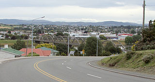
WAlexandra is a town in the Central Otago district of the South Island of New Zealand. It is on the banks of the Clutha River, on State Highway 8, 188 kilometres (117 mi) by road from Dunedin and 33 kilometres (21 mi) south of Cromwell. The town is home to 5,790 people as of June 2020.
 W
WBalclutha is a town in Otago, lying towards the end of the Clutha River, on the east coast of the South Island of New Zealand. It is about halfway between Dunedin and Invercargill on the Main South Line railway, State Highway 1 and the Southern Scenic Route. Balclutha has a population of 4,230, and is the largest town in South Otago.
 W
WThe Central Otago wine region is a geographic indication in New Zealand's South Island, and the world's southernmost commercial wine growing region. Central Otago is best known for Pinot Noir, but many white wine varieties are also popular.
 W
WThe Clutha Mata-Au River Parkway Group, New Zealand, was formed in October 2003, and is an Incorporated Society, with Charitable and Donee Status. The Group was set up in response to land development issues along the Clutha Mata-Au River corridor, much of which has high scenic and recreational values. The project aims to establish a regional river parkway, including a river trail, along the entire 338 km river corridor from Lake Wanaka to the Pacific Ocean.
 W
WThe Clyde Dam, New Zealand's third largest hydroelectric dam, is built on the Clutha River near the town of Clyde. It is owned and operated by Contact Energy.
 W
WClyde, formerly Dunstan, is a small town in Central Otago, New Zealand with a population of 1023 in 2018. It is located on the Clutha River, between Cromwell and Alexandra.
 W
WThe Cromwell Gorge is a deep gorge on the Clutha River in the Otago region of New Zealand's South Island. It stretches for 20 km south of the town of Cromwell towards Alexandra. It is one of two substantial river gorges in Central Otago, the other being the Kawarau Gorge, located to the west of Cromwell.
 W
WCromwell is a town in Central Otago in the Otago region of New Zealand.
 W
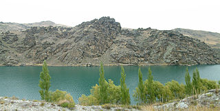
WLake Dunstan is a man-made lake and reservoir in the South Island of New Zealand.
WLowburn is a small settlement in Central Otago, in the South Island of New Zealand. It is located close to the shores of the man-made Lake Dunstan, which was formed by the building of the Clyde Dam. Lowburn lies between the towns of Wanaka and Cromwell.
 W
WThe Otago Gold Rush was a gold rush that occurred during the 1860s in Central Otago, New Zealand. This was the country's biggest gold strike, and led to a rapid influx of foreign miners to the area - many of them veterans of other hunts for the precious metal in California and Victoria, Australia.
 W
WThe Roxburgh Dam is the earliest of the large hydroelectric projects in the southern South Island of New Zealand. It lies across the Clutha River / Mata-Au, some 160 kilometres (99 mi) from Dunedin, some 9 kilometres (5.6 mi) to the north of the town of Roxburgh. The settlement of Lake Roxburgh Village is close to the western edge of the dam.
 W
WLake Roxburgh is an artificial lake, created by the Roxburgh Dam, the earliest of the large hydroelectric projects in the southern South Island of New Zealand. It lies on the Clutha River, some 160 km (99 mi) from Dunedin. It covers an area of some 6 km2 (2.3 sq mi), and extends for nearly 30 km (19 mi) towards the town of Alexandra. The town of Roxburgh lies 5 kilometres (3.1 mi) south of the Dam.
 W
WLake Wānaka is New Zealand's fourth-largest lake. In the Otago region, it is 278 meters above sea level, covers 192 km2 (74 sq mi), and is more than 300 m (980 ft) deep.