 W
WThe Hawaiian–Emperor seamount chain is a series of volcanoes and seamounts extending about 6,200 kilometres (3,900 mi) across the Pacific Ocean. The chain has been produced by the movement of the ocean crust over the Hawaiʻi hotspot, an upwelling of hot rock from the Earth's mantle. As the oceanic crust moves the volcanoes farther away from their source of magma, their eruptions become less frequent and less powerful until they eventually cease to erupt altogether. At that point, erosion of the volcano and subsidence of the seafloor cause the volcano to gradually diminish. As the volcano sinks and erodes, it first becomes an atoll island and then an atoll. Further subsidence causes the volcano to sink below the sea surface, becoming a seamount and/or a guyot. This list documents the most significant volcanoes in the chain, ordered by distance from the hotspot; however, there are many others that have yet to be properly studied.
 W
WThe fifteen volcanoes that make up the eight principal islands of Hawaii are the youngest in a chain of more than 129 volcanoes that stretch 5,800 kilometres (3,600 mi) across the North Pacific Ocean, called the Hawaiian–Emperor seamount chain. Hawaiʻi's volcanoes rise an average of 4,600 metres (15,000 ft) to reach sea level from their base. The largest, Mauna Loa, is 4,169 metres (13,678 ft) high. As shield volcanoes, they are built by accumulated lava flows, growing a few meters or feet at a time to form a broad and gently sloping shape.
 W
WThe Hawaiian Volcano Observatory (HVO) is an agency of the U.S. Geological Survey, with temporary offices located in Hilo on the Island of Hawaiʻi. The former volcano observatory clifftop facility and HVO offices, closed due to structural damage in 2018, is located at Uwekahuna Bluff on the rim of Kīlauea Caldera. The observatory staff and equipment monitors four active Hawaiian volcanoes: Kīlauea, Mauna Loa, Hualālai, and Haleakalā. Because Kīlauea and Mauna Loa are significantly more active than Hualālai and Haleakalā, much of the observatory's research is concentrated on the former two mountains.
 W
WThe Hawaiian–Emperor seamount chain is a mostly undersea mountain range in the Pacific Ocean that reaches above sea level in Hawaii. It is composed of the Hawaiian ridge, consisting of the islands of the Hawaiian chain northwest to Kure Atoll, and the Emperor Seamounts: together they form a vast underwater mountain region of islands and intervening seamounts, atolls, shallows, banks and reefs along a line trending southeast to northwest beneath the northern Pacific Ocean. The seamount chain, containing over 80 identified undersea volcanoes, stretches about 6,200 kilometres (3,900 mi) from the Aleutian Trench in the far northwest Pacific to the Loʻihi seamount, the youngest volcano in the chain, which lies about 35 kilometres (22 mi) southeast of the Island of Hawaiʻi.
 W
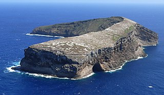
WKāohikaipu is an islet located in Honolulu County, Hawaii. It is situated 0.6 miles away from nearby Mānana Island. The total size of Kāohikaipu is 11 acres.
 W
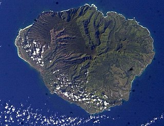
WKauaʻi, anglicized as Kauai, is geologically the second-oldest of the main Hawaiian Islands. With an area of 562.3 square miles (1,456.4 km2), it is the fourth-largest of these islands and the 21st largest island in the United States. Known also as the "Garden Isle", Kauaʻi lies 105 miles (169 km) across the Kauaʻi Channel, northwest of Oʻahu. This island is the site of Waimea Canyon State Park.
 W
WKaʻula Island, also called Kaʻula Rock, is a small, crescent-shaped offshore islet in the Hawaiian Islands.
 W
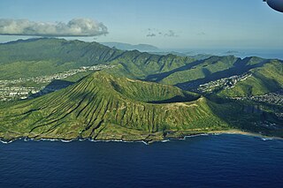
WKoko Crater is an extinct tuff cone located on the Hawaiian island of Oahu near Hawaii Kai. It is northeast of Hanauma Bay and south of the Koʻolau Range.
 W
WLehua Island is a small, crescent-shaped island in the Hawaiian islands, 0.7 miles (1.1 km) north of Niʻihau, due west of Kauai. The uninhabited, 279-acre (1.13 km2) barren island is a tuff cone which is part of the extinct Niʻihau volcano.
 W
WLōʻihi Seamount is an active submarine volcano about 35 km (22 mi) off the southeast coast of the island of Hawaii. The top of the seamount is about 975 m (3,000 ft) below sea level. This seamount is on the flank of Mauna Loa, the largest shield volcano on Earth. Lōʻihi, meaning "long" in Hawaiian, is the newest volcano in the Hawaiian–Emperor seamount chain, a string of volcanoes that stretches about 6,200 km (3,900 mi) northwest of Lōʻihi. Unlike most active volcanoes in the Pacific Ocean that make up the active plate margins on the Pacific Ring of Fire, Lōʻihi and the other volcanoes of the Hawaiian–Emperor seamount chain are hotspot volcanoes and formed well away from the nearest plate boundary. Volcanoes in the Hawaiian Islands arise from the Hawaii hotspot, and as the youngest volcano in the chain, Lōʻihi is the only Hawaiian volcano in the deep submarine preshield stage of development.
WMāhukona is a submerged shield volcano on the northwestern flank of the Island of Hawaiʻi. A drowned coral reef at about 3,770 feet below sea level and a major break in slope at about 4,400 feet below sea level represent old shorelines. The summit of the shield volcano was once 800 feet above sea level. It has now subsided below sea level. A roughly circular caldera marks the summit of Māhukona. A prominent rift zone extends to the west. A second rift zone probably extended to the east but has been buried by younger volcanoes. The main shield-building stage of volcanism ended about 470,000 years ago. The summit of the shield volcano subsided below sea level between 435,000 and 365,000 years ago. This makes Māhukona the oldest volcano to build Hawaiʻi island, compared to Kohala to the east and Mauna Kea to the east. The Monterey Bay Aquarium Research Institute investigated the area with a remotely controlled submarine in 2001.
 W
WNecker Island is a small island in the Northwestern Hawaiian Islands. It is located at 23°34′30″N 164°42′01″W in the Pacific Ocean, 155 miles northwest of Nihoa and 8 miles north of the Tropic of Cancer. It contains important prehistoric archaeological sites of the Hawaiian culture and is part of the Hawaiian Islands National Wildlife Refuge within the Northwestern Hawaiian Islands National Monument.
 W
WNiʻihau anglicized as Niihau is the westernmost main and seventh largest inhabited island in Hawaii. It is 17.5 miles (28.2 km) southwest of Kauaʻi across the Kaulakahi Channel. Its area is 69.5 square miles (180 km2). Several intermittent playa lakes provide wetland habitats for the Hawaiian coot, the Hawaiian stilt, and the Hawaiian duck. The island is designated as critical habitat for Brighamia insignis, an endemic and endangered species of Hawaiian lobelioid. The United States Census Bureau defines Niʻihau and the neighboring island and State Seabird Sanctuary of Lehua as Census Tract 410 of Kauai County, Hawaii. Its 2000 census population was 160; Its 2010 census population was 170.
 W
WSouth Arch volcanic field is an underwater volcanic field south of Hawaiʻi Island. It was active during the last 10,000 years, and covers an area of 35 by 50 kilometres at a depth of 4,950 metres (16,240 ft).
 W
WMount Waiʻaleʻale is a shield volcano and the second highest point on the island of Kauaʻi in the Hawaiian Islands. Its name literally means "rippling water" or "overflowing water"