 W
WThe Atlantic Ocean is the second-largest of the world's oceans, with an area of about 106,460,000 km2 (41,100,000 sq mi). It covers approximately 20 percent of Earth's surface and about 29 percent of its water surface area. It is known to separate the "Old World" from the "New World" in European perception of the World.
 W
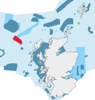
WThe Barra Fan and Hebrides Terrace Seamount is the name given to a Nature Conservation Marine Protected Area that lies in Scottish waters to the west of the Outer Hebrides, adjacent to the boundary with Ireland. It covers two distinct geological features of the North Atlantic Ocean: the Barra Fan and the Hebrides Terrace Seamount.
 W
WThe Bear Seamount is a guyot or flat-topped underwater volcano in the Atlantic Ocean. It is the oldest of the New England Seamounts, which was active more than 100 million years ago. It was formed when the North American Plate moved over the New England hotspot. It is located inside the Northeast Canyons and Seamounts Marine National Monument, which was proclaimed by President of the United States Barack Obama to protect the seamount's biodiversity.
 W
WThe Geikie Slide is a submarine landslide on the seabed of the North Atlantic Ocean to the northwest of Scotland. The slide occurs in a region known as the Hebridean Slope, the continental slope where the seabed drops from the continental shelf surrounding Britain into the deep ocean. Since 2014 an area of 2,215 square kilometres (855 sq mi) has been designated as a Nature Conservation Marine Protected Area under the name Geikie Slide and Hebridean Slope MPA.
 W
WGeorges Bank is a large elevated area of the sea floor between Cape Cod, Massachusetts, and Cape Sable Island, Nova Scotia (Canada). It separates the Gulf of Maine from the Atlantic Ocean.
 W
WThe Gorringe Ridge is a seamount in the Atlantic Ocean. It is located about 130 miles (210 km) west of Portugal, between the Azores and the Strait of Gibraltar along the Azores–Gibraltar fault zone. It is about 60 km wide and 180 km long in the northeast direction.
 W
WMacaronesia is a collection of four archipelagos in the North Atlantic Ocean off the coast of the continents of Europe and Africa. Each archipelago is made up of a number of Atlantic oceanic islands formed by seamounts on the ocean floor with peaks above the ocean's surface. The Macaronesian islands belong to three countries: Portugal, Spain, and Cape Verde. Politically, the islands belonging to Portugal and Spain are part of the European Union. Geologically, Macaronesia is part of the African Plate, including the Azores, which mark its edge at the meeting point with the Eurasian and North American Plates.
 W
WThe Mid-Atlantic Bight is a coastal region running from Massachusetts to North Carolina. It contains the New York Bight.
 W
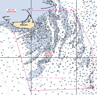
WNantucket Shoals is an area of dangerously shallow water in the Atlantic Ocean that extends from Nantucket Island, Massachusetts, eastward for 23 miles (37 km) and southeastward for 40 miles (64 km); in places water depth can be as shallow as 3 feet (0.91 m). Depth soundings are unpredictable due to the constant change caused by strong currents, which are rotary rather than reversing. The shoals lie just off of a major transatlantic shipping lane. Numerous ships have been wrecked here, most recently and notably the oil tanker Argo Merchant in December 1976. Until 1983, the edge of the shoals was guarded by the Nantucket Lightship.
 W
WThe Nazaré Canyon is an undersea canyon just off the coast of Nazaré in Oeste region of Portugal, in the Eastern North Atlantic Ocean. It is the largest submarine canyon in Europe going down to around 5,000 metres (16,000 ft) deep and about 230 kilometres (140 mi) long.
 W
WThe Northeast Georgia Rise is an oceanic plateau located in the South Atlantic Ocean northeast of South Georgia Island and west of the Falkland Plateau.
 W
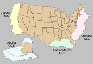
WThe Outer Continental Shelf (OCS) is a peculiarity of the political geography of the United States. The OCS is the part of the internationally recognized continental shelf of the United States which does not fall under the jurisdictions of the individual U.S. states.
 W
WThe Patagonian or Argentine Shelf is part of the South American continental shelf belonging to the Argentine Sea on the Atlantic seaboard, south of about 35°S. It adjoins the coasts of Uruguay, Argentina and the Falkland Islands. Various authorities quote different dimensions of the shelf, depending on how they define its limits. Quoted statistics cites its area as being from 1.2 to 2.7 million square kilometres and its maximum width as being between 760 and 850 kilometres. The shelf itself can be divided into a 100 km band where the seabed slopes at about 1 m/km then a wide plain where the seabed slopes gently to 200 m isobath. Apart from the Falklands Plateau, the seabed then falls by up to 10 m/km to 2000 m and more.
 W
WThe Porcupine Abyssal Plain (PAP) is located in international waters, adjacent to the Irish continental margin. The PAP lies beyond the Porcupine Bank's deepest point and is southwest of it. It has a muddy seabed, with scattered abyssal hills that covers an area approximately half the size of Europe's landmass. Its depth ranges from 4,000 metres (13,000 ft) to 4,850 m (15,910 ft).
 W
WThe Scotian Shelf is a geological formation, part of the Continental shelf, located southwest of Nova Scotia, Canada. It covers an area of 120,000 square kilometres (46,000 sq mi), is 700 kilometres (430 mi) long and ranges in width from 120 to 240 kilometres. It has an average depth of 90 metres (300 ft). The Scotian Shelf contains the ecologically important Scotian Shelf Large Marine Ecosystem (LME) and the Scotian Shelf Waters (SSW).