 W
WBreheimen is a mountain range in the Innlandet and Vestland counties in Norway. The area lies west of the Jotunheimen mountain range. The mountain range lies to the northwest of the Sognefjellsvegen road, north of the Sognefjorden, south of the Nordfjorden and Norwegian National Road 15, and east of Norwegian National Road 5 and European route E39. The mountain range includes Jostedalsbreen National Park and Breheimen National Park.
 W
WDigernessundet is a strait in the municipality of Stord in Vestland county, Norway. The 3-kilometre (1.9 mi) long strait runs between the islands of Føyno and Stord, which connects the Stokksundet to the north with the Bømlafjorden to the south. The Stord Bridge crosses the Digernessundet.
WFedjeosen is a strait or stretch of open sea in Vestland county, Norway. It is located between the island of Fedje in Fedje Municipality and the island of Nordøyane in Øygarden Municipality. The strait has a width of about 3.5-kilometre (2.2 mi) and leads into the Fedjefjorden. Hellisøy Lighthouse is located at the northern side of Fedjeosen.
 W
WHallingskarvet is a mountain range in southern Norway stretching from Geilo to Finse in Vestland and Viken counties. The highest point is the 1,933-metre (6,342 ft) tall mountain Folarskardnuten in Hol Municipality in Viken county.
 W
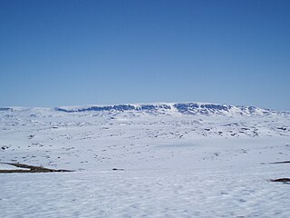
WHardangervidda is a mountain plateau in central southern Norway, covering parts of Vestland, Vestfold og Telemark, and Viken counties. It is the largest plateau of its kind in Europe, with a cold year-round alpine climate, and one of Norway's largest glaciers, Hardangerjøkulen, is situated here. Much of the plateau is protected as part of Hardangervidda National Park. Hardangervidda is a popular tourist and leisure destination, and it is ideal for many outdoor activities.
 W
WHurrungane is a mountain range in the municipalities Luster and Årdal in Vestland county, Norway. The area is southwest in the larger mountain range Jotunheimen and is also part of Jotunheimen National Park.
 W
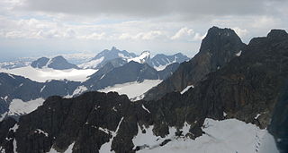
WJotunheimen is a mountainous area of roughly 3,500 km² in southern Norway and is part of the long range known as the Scandinavian Mountains. The 29 highest mountains in Norway are all in Jotunheimen, including the very highest – Galdhøpiggen. Jotunheimen straddles the border between the counties of Innlandet and Vestland.
 W
WKvamskogen is a mountain plateau in the Hardanger region of Vestland county, Norway. It is located in the municipalities of Samnanger and Kvam. Traditionally, the term was used only for the parts of the plateau located in Kvam municipality, but today it is used for the entire plateau. Kvamskogen contains several ski resorts, and more than 1700 cabins, the third highest concentration of cabins in the country.
 W
WLangenuen is a strait in Vestland county, Norway. The 40-kilometre (25 mi) strait runs between the islands of Stord and Huftarøy on the west, and Tysnesøy and Reksteren on the east. The strait ranges from 1 to 4 kilometres wide, and it forms the municipal boundaries between the municipalities of Austevoll, Tysnes, Fitjar, and Stord.
 W
WØygarden is a municipality in Vestland county, Norway. It is an island municipality located in the traditional district of Midhordland, stretching along the west coast of the county. The village of Straume is the administrative centre of the municipality. Other villages in the municipality include Alveim, Blomvåg, Vikavågen, Ågotnes, Fjell, Foldnes, Knappskog, Knarrevik, Kolltveit, Landro, Sekkingstad, Skogsvåg, Klokkarvik, Tælavåg, Kausland, and Hammarsland.
 W
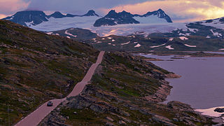
WSognefjellet is a mountainous area and mountain pass which connects Lustrafjorden and its surrounding valley with the Ottadalen valley in the Jotunheimen area. Sognefjellet is located in Luster Municipality and Lom Municipality in Norway. Sognefjellsvegen, part of County Road 55, runs through the mountains and over the pass.
WThe Sognefjellsvegen or Sognefjellsveien is the highest mountain pass road in Northern Europe. Part of County Road 55, it is located in Innlandet and Vestland counties in Norway. It is a national tourist road and starts in the village of Lom in the municipality of Lom, it then travels over the Sognefjell mountain area, and it ends in the village of Gaupne in the municipality of Luster. The road was opened on 16 July 1938. The road passes through the Jotunheimen, Hurrungane, and Breheimen mountains. The highest point is Fantesteinen at 1,434 metres (4,705 ft). During the winters there is a lot of snow, and so the road is closed from November through May. The road passes between Jotunheimen National Park and Breheimen National Park.
 W
WSotra or Store Sotra is the name of a large island in Øygarden Municipality in Vestland county, Norway, located just west of the city of Bergen. It is part of a pair of islands called 'Sotra' and 'Litlesotra' that are part of a large archipelago stretching from Fedje southwards along the coast of Norway. The larger island of the two is Store Sotra, and the smaller of the two is Litlesotra. Roughly 28,700 (2017) people live on the two islands of Sotra, with the larger island having a population of about 19,100 (2017) and 9,589 (2017) living on the smaller island.
 W
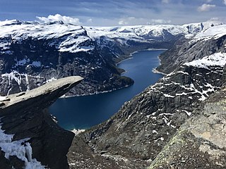
WTrolltunga is a rock formation situated about 1,100 metres (3,600 ft) above sea level in Ullensvang Municipality in Vestland county, Norway. The cliff juts horizontally out from the mountain, about 700 metres (2,300 ft) above the north side of the lake Ringedalsvatnet.
 W
WVardetangen is a point in Austrheim Municipality in Vestland county, Norway. This place is notable in that it is the westernmost mainland point in Norway proper. The point is located on the mainland Lindås peninsula, jutting out into the Fensfjorden. It is located about 3.8 kilometres (2.4 mi) west of the Mongstad industrial area.