 W
WThe Brushy Mountains are a mountain range located in northwestern North Carolina. They are an isolated "spur" of the much larger Blue Ridge Mountains, separated from them by the Yadkin River valley. A deeply eroded range, they move from the southwest to the northeast, and cross five counties in North Carolina: Caldwell, Alexander, Wilkes, Iredell, and Yadkin.
 W
WCrowders Mountain is one of two main peaks within Crowders Mountain State Park, the other peak being The Pinnacle. The park is located in the western Piedmont of North Carolina between the cities of Kings Mountain and Gastonia or about 25 miles (40 km) west of Charlotte. Crowders Mountain abruptly rises nearly 800 feet (240 m) above the surrounding terrain, and has an elevation of 1,625 feet above sea level.
 W
WGlassy Mountain is a mountain close to Pickens, South Carolina, USA, in Northwestern South Carolina, with a summit elevation of 1647 feet above mean sea level. While it is an isolated monadnock, it is still close to the Blue Ridge, providing views of nearby summits such as Table Rock and Caesar's Head as well as Greenville. The mountain gets its name from a large, bare, granite face on its North side. At the top of this rock face are small springs that trickle down the mountain, giving it a "glassy" appearance in the sun. It is easily accessible, as a small service road for transmitter towers leads to the summit. Local high-schoolers often paint the rock face with graduation years. These year numbers can be so large as to be seen on aerial imaging of the mountain
 W
WHanging Rock State Park is a 9,011-acre (3,647 ha) North Carolina state park in Stokes County, North Carolina in the United States. The park is 30 miles (48 km) north of Winston-Salem and is located approximately 2 miles (3.2 km) from Danbury in Stokes County.
 W
WHibriten Mountain, located just east of Lenoir, North Carolina, marks the western end of the Brushy Mountains range. At 2,211 feet, the mountain's summit is nearly 1,000 feet above the surrounding terrain. The summit is well known to the locals for its large welcome light which glows at night in the shape of a star in the weeks before Christmas and a cross before Easter.
 W
WThe Pinnacle, is one of the two main peaks located within Crowders Mountain State Park. The other peak is Crowders Mountain. The park is located in the western Piedmont of North Carolina between the cities of Kings Mountain and Gastonia.
 W
WLittle Mountain is a monadnock that is the highest point in the Midlands region of South Carolina. It has an elevation of 813 feet above mean sea level and is located in southeastern Newberry County, about 25 miles from Columbia. The monadnock itself rises 300 feet above the surrounding belt of hills and is formed of Carolina slate.
 W
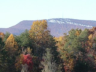
WMoore's Knob is the highest mountain in the Sauratown Mountains of Stokes County, North Carolina. The Sauratown Mountains are an isolated remnant of the much larger Blue Ridge Mountains far to the west and north. A rugged, deeply eroded range, the Sauras feature dramatic rock cliffs which can be seen for miles. Moore's Knob has an elevation of 2,579 feet above sea level.
 W
WOcconeechee Mountain State Natural Area is a North Carolina state park in Orange County, North Carolina in the United States. Located adjacent to the town of Hillsborough, it covers 221 acres (0.89 km2) and includes Occoneechee Mountain, the highest point (867 ft) in Orange County and a settlement of the Occaneechi tribe.
 W
WParis Mountain State Park is located five miles (8 km) north of Greenville, South Carolina. Activities available in the 1,540-acre (6 km2) park include hiking, biking, swimming and picnicking. The 13-acre (52,609 m2) Lake Placid offers swimming and fishing. Canoes, kayaks, and pedal boats are seasonally available for rental; private boats are not permitted. Camping is allowed and campsites range from rustic, back country sites to paved sites with water and electricity hook-ups. The park's Civilian Conservation Corps (CCC) structures, including the Camp Buckhorn lodge, are listed on the National Register of Historic Places. m.
 W
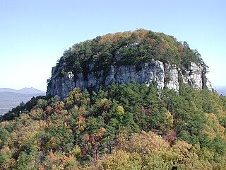
WPilot Mountain, a metamorphic quartzite monadnock rising to a peak 2,421 feet (738 m) above sea level, is one of the most distinctive natural features in the U.S. state of North Carolina. It is a remnant of the ancient chain of Sauratown Mountains. The Saura Native Americans, the region's earliest known inhabitants, called the mountain "Jomeokee", meaning "great guide".
 W
WPores Knob is a mountain peak located in Wilkes County, North Carolina, USA.
 W
WThe Sauratown Mountains, which are sometimes called "the mountains away from the mountains", are an isolated mountain range located within Stokes and Surry counties in the U.S. state of North Carolina. The vast majority of the range is located in Stokes County. Although the range occupies only 5% of Stokes County's area, it dominates the county's scenery from almost every direction. The Sauras rise sharply 800 to 1,700 feet above the surrounding terrain. The Sauratown Mountains were named after the "Saura", a Siouan-speaking Native American tribe that lived in the area before European settlers arrived in the early 1700s. The range consists of rugged, heavily forested ridges frequently broken by large quartzite rock cliffs that can be seen for miles. The Sauratown Mountains are known for offering some of the best rock climbing in North Carolina. The highest point in the Sauratown Mountains is Moore's Knob, which rises to 2,579 feet.
 W
WStone Mountain is the centerpiece of Stone Mountain State Park. It is a dome of exposed granite of Devonian age, which has intruded into the gneiss of the Precambrian Alligator Back Formation. It rises sharply over 600 feet above the surrounding terrain. The mountain, which has an elevation of 2,305 feet (706 m) above sea level, is known for its barren sides and distinctive brown-gray color, and can be seen for miles. The mountain offers some of the best rock climbing in North Carolina, and the park's creeks and streams feature excellent brook trout fishing.
WStone Mountain State Park is a 14,353-acre (58.08 km2) North Carolina state park in Alleghany County and Wilkes County, North Carolina.