 W
WThis is an incomplete list of extinct animals of North America. This list covers only extinctions from the Holocene epoch, a geological period that extends from the present day back to about 10,000 radiocarbon years, approximately 11,430 ± 130 calendar years BP.
 W
WThe Californian turkey is an extinct species of turkey indigenous to the Pleistocene and early Holocene of California. It has been estimated that the Californian turkey went extinct about 10,000 years ago.
 W
WThe Canadian Cascade Arc, also called the Canadian Cascades, is the Canadian segment of the North American Cascade Volcanic Arc. Located entirely within the Canadian province of British Columbia, it extends from the Cascade Mountains in the south to the Coast Mountains in the north. Specifically, the southern end of the Canadian Cascades begin at the Canada–United States border. However, the specific boundaries of the northern end are not precisely known and the geology in this part of the volcanic arc is poorly understood. It is widely accepted by geologists that the Canadian Cascade Arc extends through the Pacific Ranges of the Coast Mountains. However, others have expressed concern that the volcanic arc possibly extends further north into the Kitimat Ranges, another subdivision of the Coast Mountains, and even as far north as Haida Gwaii.
 W
WA list of prehistoric and extinct species whose fossils have been found in the La Brea Tar Pits, located in present-day Hancock Park, a city park on the Miracle Mile section of the Mid-Wilshire district in Los Angeles, California.
 W
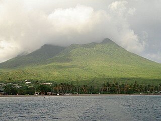
WMount Liamuiga is a 3,792-foot (1,156 m) stratovolcano which forms the western part of the island of Saint Kitts. The peak is the highest point on the island of Saint Kitts, in the federation of Saint Kitts and Nevis, and in the entire British Leeward Islands, as well as one of the tallest peaks in the eastern Caribbean archipelago. The peak is topped by a 0.6-mile (1 km) wide summit crater, which contained a shallow crater lake until 1959. As of 2006, the crater lake had re-formed. The last verified eruptions from the volcano were about 1,800 years ago, while reports of possible eruptions in 1692 and 1843 are considered uncertain.
 W
WMagic Mountain is a large long-lived hydrothermal vent field on the Southern Explorer Ridge, located about 150 miles west of Vancouver Island, British Columbia, Canada. Unlike most hydrothermal systems found in the Pacific Ocean, Magic Mountain is situated outside the Explorer Ridge. Its source is believed to rise along fault systems.
 W
WThe Marysvale volcanic field is located in southwestern Utah, United States.
WThe Californian turkey is an extinct species of turkey indigenous to the Pleistocene and early Holocene of California. It has been estimated that the Californian turkey went extinct about 10,000 years ago.
 W
WThe Mount Cayley volcanic field is a remote volcanic zone on the South Coast of British Columbia, Canada, stretching 31 km (19 mi) from the Pemberton Icefield to the Squamish River. It forms a segment of the Garibaldi Volcanic Belt, the Canadian portion of the Cascade Volcanic Arc, which extends from Northern California to southwestern British Columbia. Most of the Cayley volcanoes were formed during periods of volcanism under sheets of glacial ice throughout the last glacial period. These subglacial eruptions formed steep, flat-topped volcanoes and subglacial lava domes, most of which have been entirely exposed by deglaciation. However, at least two volcanoes predate the last glacial period and both are highly eroded. The field gets its name from Mount Cayley, the largest and most persistent volcano, located at the southern end of the Powder Mountain Icefield. This icefield covers much of the central portion of the volcanic field and is one of the several glacial fields in the Pacific Ranges of the Coast Mountains.
 W
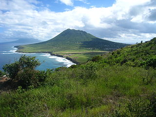
WNevis Peak is a potentially active volcano which is located in the centre of the island of Nevis of the Federation of Saint Kitts and Nevis in the West Indies. The stratovolcano rises to a height of 985 metres (3,232 ft) and is the highest point on the island. There have been no eruptions since prehistory, but there are active fumaroles and hot springs on the coastal slopes of the island, and these represent low-level volcanic activity.
 W
WThe Quill is a stratovolcano located on the island of Sint Eustatius in the Caribbean Netherlands. The summit elevation is 601 m (1,972 ft) above sea level. It is also the second highest mountain in the Netherlands.
 W
WThe Snake River Plain is a geologic feature located primarily within the U.S. state of Idaho. It stretches about 400 miles (640 km) westward from northwest of the state of Wyoming to the Idaho-Oregon border. The plain is a wide, flat bow-shaped depression and covers about a quarter of Idaho. Three major volcanic buttes dot the plain east of Arco, the largest being Big Southern Butte.
 W
WCraters of the Moon National Monument and Preserve is a U.S. national monument and national preserve in the Snake River Plain in central Idaho. It is along US 20, between the small towns of Arco and Carey, at an average elevation of 5,900 feet (1,800 m) above sea level. The protected area's features are volcanic and represent one of the best-preserved flood basalt areas in the continental United States.
 W
WThe West Napa Fault is a 57 km (35 mi) long geologic fault in Napa County, in the North Bay region of the San Francisco Bay Area in northern California. It is believed to be the northern extension of the Calaveras Fault in the East Bay region.
 W
WThe Yellowstone hotspot is a volcanic hotspot in the United States responsible for large scale volcanism in Idaho, Montana, Nevada, Oregon, and Wyoming as the North American tectonic plate moved over it. It formed the eastern Snake River Plain through a succession of caldera-forming eruptions. The resulting calderas include the Island Park Caldera, the Henry's Fork Caldera, and the Bruneau-Jarbidge caldera. The hotspot currently lies under the Yellowstone Caldera. The hotspot's most recent caldera-forming supereruption, known as the Lava Creek eruption, took place 640,000 years ago and created the Lava Creek Tuff, and the most recent Yellowstone Caldera. The Yellowstone hotspot is one of a few volcanic hotspots underlying the North American tectonic plate; another example is the Anahim hotspot.