 W
WThe Feather River is the principal tributary of the Sacramento River, in the Sacramento Valley of Northern California. The river's main stem is about 73 miles (117 km) long. Its length to its most distant headwater tributary is just over 210 miles (340 km). The main stem Feather River begins in Lake Oroville, where its four long tributary forks join together—the South Fork, Middle Fork, North Fork, and West Branch Feather Rivers. These and other tributaries drain part of the northern Sierra Nevada, and the extreme southern Cascades, as well as a small portion of the Sacramento Valley. The total drainage basin is about 6,200 square miles (16,000 km2), with approximately 3,604 square miles (9,330 km2) above Lake Oroville.
 W
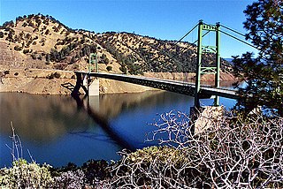
WThe Bidwell Bar Bridge, in Oroville, California, refers to two suspension bridges that cross different parts of Lake Oroville. The original Bidwell Bar Bridge was the first steel suspension bridge in California. The $35,000, 240-foot-long (73 m) original was completed in December 1855, and was built of materials transported from Troy, New York, via Cape Horn. Most of the money was put up by Judge Joseph Lewis, a Virginian who moved to Bidwell's Bar in 1849. The bridge originally crossed the Middle Fork Feather River and is the only one of several suspension bridges built in the area in the 1850s that still remains. It remained open to vehicle traffic until 1954.
 W
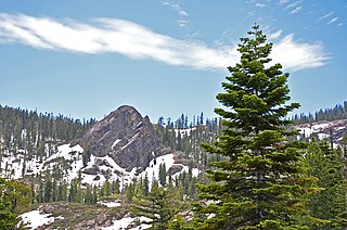
WThe Bucks Lake Wilderness is a 23,958-acre (97.0 km2) wilderness area located in the Plumas National Forest section of the Sierra Nevada, in northeastern California, United States.
 W
WFeather Falls is a waterfall located on the Fall River, a tributary of the Middle Fork Feather River, within the Plumas National Forest in the Sierra Nevada mountain range in Butte County, eastern California, United States.
 W
WThe Feather Headwaters are 3 watersheds totaling 3,450 sq mi (8,900 km2) and which drain to Lake Oroville. The North Fork Feather Watershed is 1,090 sq mi (2,800 km2)—including the West Branch drainage of about 282.5 sq mi (732 km2). The East Branch North Fork Feather Watershed is 1,010 sq mi (2,600 km2), and the Middle Fork Feather Watershed is 1,350 sq mi (3,500 km2)—including the South Fork drainage of about 132 sq mi (340 km2). Headwaters drainage is impaired by the Palermo Canal at Oroville Dam, the Hendricks Canal at the West Branch Feather River, and the Miners Ranch Canal at the South Fork's Ponderosa Reservoir. Additionally, the Pacific Gas and Electric Company releases Upper Feather water into the Hyatt Generating-Pumping Plant for hydroelectric generation during daily peak demand.
WThe Feather River is the principal tributary of the Sacramento River, in the Sacramento Valley of Northern California. The river's main stem is about 73 miles (117 km) long. Its length to its most distant headwater tributary is just over 210 miles (340 km). The main stem Feather River begins in Lake Oroville, where its four long tributary forks join together—the South Fork, Middle Fork, North Fork, and West Branch Feather Rivers. These and other tributaries drain part of the northern Sierra Nevada, and the extreme southern Cascades, as well as a small portion of the Sacramento Valley. The total drainage basin is about 6,200 square miles (16,000 km2), with approximately 3,604 square miles (9,330 km2) above Lake Oroville.
 W
WThe Feather River Route is a rail line that was built and operated by the Western Pacific Railroad. It was constructed between 1906 and 1909, and connects the cities of Oakland, California, and Salt Lake City, Utah. The line was built to compete with the Central Pacific Railroad, which at the time held a nearly complete monopoly on Northern California rail service. The route derives its name from its crossing of the Sierra Nevada, where it follows both the North and Middle Forks of the Feather River. The route is famous for its impressive engineering qualities and its considerable scenic value. All of the route is now owned and operated by the Union Pacific Railroad; however, the Union Pacific has transferred significant portions of the route to other lines. The portion still called the Feather River Route by the Union Pacific runs from the California Central Valley to Winnemucca, Nevada and has been divided into three subdivisions named the Sacramento, Canyon and Winnemucca subdivisions.
 W
WLake Oroville is a reservoir formed by the Oroville Dam impounding the Feather River, located in Butte County, northern California. The lake is situated 5 miles (8.0 km) northeast of the city of Oroville, within the Lake Oroville State Recreation Area, in the western foothills of the Sierra Nevada. Known as the second-largest reservoir in California, Lake Oroville is treated as a keystone facility within the California State Water Project by storing water, providing flood control, recreation, freshwater releases assist in controlling the salinity intrusion Sacramento-San Joaquin Delta and protecting fish and wildlife.
WLake Oroville State Recreation Area (LOSRA) is a state park unit of California, United States, surrounding Lake Oroville, a reservoir on the Feather River. It is located in Butte County outside Oroville, California. The 29,447-acre (11,917 ha) park was established in 1967. The recreation area "includes Lake Oroville and the surrounding lands and facilities within the project area as well as the land and waters in and around the Diversion Pool and Thermalito Forebay, downstream of Oroville Dam."
 W
WLas Plumas is a former settlement in Butte County, California.
 W
WOroville Dam is an earthfill embankment dam on the Feather River east of the city of Oroville, California, in the Sierra Nevada foothills east of the Sacramento Valley. At 770 feet (235 m) high, it is the tallest dam in the U.S. and serves mainly for water supply, hydroelectricity generation and flood control. The dam impounds Lake Oroville, the second largest man-made lake in the state of California, capable of storing more than 3.5 million acre feet.
 W
WIn February 2017, Oroville Dam's main and emergency spillways were damaged, prompting the evacuation of more than 180,000 people living downstream along the Feather River and the relocation of a fish hatchery.
 W
WThe Oroville–Thermalito Complex is a group of reservoirs, structures, and facilities located in and around the city of Oroville in Butte County, California. The complex serves not only as a regional water conveyance and storage system, but is the headwaters for, and therefore perhaps is the most vital part of, the California Department of Water Resources' State Water Project, the world's largest publicly built and operated water and power development and conveyance system.
 W
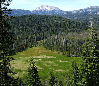
WPlumas National Forest is a 1,146,000-acre (4,638 km2) United States National Forest located at the northern terminus of the Sierra Nevada, in northern California. The Forest was named after its primary watershed, the Rio de las Plumas, or Feather River.
 W
WPlumas-Eureka State Park is a California state park located in the Sierra Nevada and Cascade Range in Plumas County, California.