 W
WThe Belizean Coast mangroves form one of the ecoregions that belong to the mangroves biome, as defined by the World Wildlife Fund. This ecoregion is located along the coast of Belize and of Amatique Bay in Guatemala. It covers an area of around 2850 km2.
 W
WThe Central American Atlantic moist forests ecoregion covers the lowland coastal forests of Honduras, southeast Guatemala, and the eastern forests of Nicaragua. Half of the ecoregion is closed-canopy tropical broadleaf evergreen forest, with tree heights reaching 50 meters. This ecoregion has the largest single fragment of natural forest in Central America, with a size of 14,629 square kilometres (5,648 sq mi). The total area is 89,979 square kilometres (34,741 sq mi).
 W
WThe Central American dry forests ecoregion, of the tropical and subtropical dry broadleaf forests biome, is located in Central America.
 W
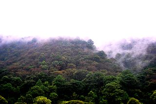
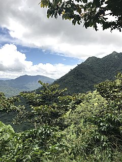
WThe Central American montane forests are an ecoregion of the tropical and subtropical moist broadleaf forests biome, as defined by the World Wildlife Fund, located in mountains of Central America.
 W
WThe Central American pine-oak forests ecoregion, in the tropical and subtropical coniferous forests biome, is found in Central America and Chiapas state of southern Mexico.
 W
WThe Chiapas Depression dry forests form one of the ecoregions that belong to the tropical and subtropical dry broadleaf forests biome, as defined by the World Wildlife Fund, in northwestern Central America.
 W
WThe Chiapas montane forests is a tropical moist broadleaf forest ecoregion in southern Mexico and extending into western Guatemala. It includes the montane tropical forests on the northern and northeastern slopes of the Chiapas highlands.
 W
WThe Mesoamerican Barrier Reef System (MBRS), also popularly known as the Great Mayan Reef or Great Maya Reef, is a marine region that stretches over 1,126 kilometres (700 mi) along the coasts of four countries – Mexico, Belize, Guatemala, and Honduras – from Isla Contoy at the northern tip of the Yucatán Peninsula south to Belize, Guatemala and the Bay Islands of Honduras. The reef system includes various protected areas and parks including the Belize Barrier Reef, Arrecifes de Cozumel National Park, Hol Chan Marine Reserve (Belize), Sian Ka'an biosphere reserve, and the Cayos Cochinos Marine Park. Belize's coastline, including the Belize Barrier Reef, is home to approximately 30% of the Mesoamerican Barrier Reef System.
 W
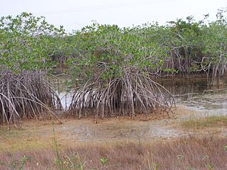
WThe Mesoamerican Gulf-Caribbean mangroves ecoregion covers the series of disconnected mangrove habitats along the eastern coast of Central America. These salt-water wetlands are found in river deltas, lagoons, and low-lying areas facing the Gulf of Mexico and Caribbean Sea, from Tampico, Mexico to central Panama. The mangroves are areas of high biodiversity and endemism. Many of the sites are protected as national parks or nature reserves.
 W
WThe Motagua Valley thornscrub is one of the ecoregions that belong to the deserts and xeric shrublands biome, as defined by the World Wildlife Fund. The ecoregion is located in the Motagua valley in eastern Guatemala, and covers an area of 2330 km2.
 W
WThe Northern Honduras mangroves form an ecoregion in the mangroves biome, as defined by the World Wildlife Fund. This ecoregion stretches along most of the Caribbean coast of Honduras, up to the east of Amatique Bay in Guatemala. It covers an area of 1036 km2. The ecoregion is threatened by the expansion of agriculture and livestock production.
 W
WThe Petén-Veracruz moist forests is an ecoregion of the tropical and subtropical moist broadleaf forest biome found in Belize, Guatemala, and Mexico.
 W
WThe Sierra Madre de Chiapas moist forests is a tropical moist broadleaf forest ecoregion in southern Mexico and southern Guatemala, extending into the northwestern corner of El Salvador.
 W
WThe Yucatán moist forests are an ecoregion of the tropical and subtropical moist broadleaf forests biome, as defined by the World Wildlife Fund.
 W
WThe Zacatonal is a montane grassland and shrubland ecoregion of central Mexico, and Guatemala. The term is also used to refer to montane grasslands.