 W
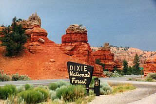
WDixie National Forest is a United States National Forest in Utah with headquarters in Cedar City. It occupies almost two million acres (8,000 km²) and stretches for about 170 miles (270 km) across southern Utah. The largest national forest in Utah, it straddles the divide between the Great Basin and the Colorado River. In descending order of forestland area it is located in parts of Garfield, Washington, Iron, Kane, Wayne, and Piute counties. The majority of forest acreage lies in Garfield County.
 W
WThe Ashdown Gorge Wilderness is located in eastern Iron County, Utah, United States, within the arid Colorado Plateau region.
 W
WBox-Death Hollow Wilderness is a 25,751 acres (104 km2) wilderness area located in south-central Utah, United States, on the Dixie National Forest. Vertical gray-orange walls of Navajo sandstone stand above two canyon tributaries of the Escalante River in Box-Death Hollow. The name Death Hollow gives reference to a number of livestock that plunged to their death trying to cross the steep canyon.
 W
WBrian Head Peak, at 11,312 feet (3,448 m) high is the highest peak on the Markagunt Plateau and in Iron County in southwestern Utah. Brian Head Peak is located east of Cedar City and just north of Cedar Breaks National Monument in Dixie National Forest. The town of Brian Head at the western base of the mountain is the location of the Brian Head Ski Resort.
 W
WCottonwood Forest Wilderness is a 2,643-acre (10.7 km2) wilderness area in the US state of Utah. It was designated March 30, 2009, as part of the Omnibus Public Land Management Act of 2009. Located within the Dixie National Forest near the base of the Pine Valley Mountains, it is adjacent to the Cottonwood Canyon Wilderness, which is part of the Red Cliffs National Conservation Area.
 W
WThe Long Valley of Utah is a 13-mile (21 km) long valley located in western Kane County. The valley is located in source water regions of waters flowing north, south, and southwest, in the west of the High Plateaus section of the Colorado Plateau; the High Plateaus section also extends into northern Arizona, the region north of the Grand Canyon.
 W
WMammoth Cave is a lava tube located on the Markagunt Plateau in the Dixie National Forest of Southern Utah, and is one of the largest lava tubes in Utah. The cave has over 2,200 feet of passage and is about a quarter mile long. It was formed by cooling lava and water less than 2,000 years ago. Due to moisture and its elevation of 8,050 feet above sea level the cave stays cool year round.
 W
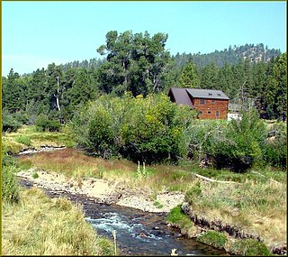
WMammoth Creek is a creek in Iron and Garfield counties in southern Utah, United States, that flows for over 20 miles (32 km) through mountains and forests from Mammoth Summit, through the Mammoth Valley, to its confluence with the Sevier River. The creek contains wild brown trout and hatchery rainbow trout.
 W
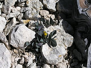
WPackera malmstenii is a rare species of flowering plant in the aster family known by the common name Podunk ragwort. It is endemic to Utah in the United States, where there about 19 occurrences in the southwestern part of the state.
 W
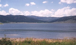
WPanguitch Lake was originally a large natural lake that has now been expanded by the creation of a 24-foot (7 m) dam to become a reservoir with a maximum surface area of 1,248 acres (5 km2). The lake, which drains into the Sevier River is located on the Markagunt Plateau, between Panguitch, Utah and Cedar Breaks National Monument. The lake is located in the Dixie National Forest in a high tourist use area near three national parks and one national monument.
WPine Valley Mountain Wilderness is a 50,232-acre (203.28 km2) wilderness area located in the Dixie National Forest in the U.S. state of Utah. It is the fourth-largest wilderness area located entirely within the state. The wilderness designation protects the Pine Valley Mountain range, a large rock outcrop surrounded by desert. The Pine Valley Mountains form the Pine Valley Laccolith, one of the largest laccoliths in the United States. Elevations in the wilderness range from 6,000 feet (1,800 m) to 10,365 feet (3,159 m) at the summit of Signal Peak.
 W
WThe Pine Valley Mountains are a mountain range in the U.S. state of Utah spanning Washington County north of the city of St. George. The highest point in the range is Signal Peak at 10,365 feet (3,159 m). The mountains are part of Dixie National Forest and are bordered to the south by the Red Cliffs National Conservation Area.
 W
WSignal Peak, with an elevation of 10,369 feet (3,160 m), is the highest peak in the Pine Valley Mountains and in Washington County in southwestern Utah, United States. Signal Peak is located north of the city of St. George and south of the community of Pine Valley in the Dixie National Forest. The summit is the highest point in the Pine Valley Mountain Wilderness.
 W
WState Route 143 (SR-143) is a state highway in the U.S. state of Utah. The entire highway has been designated the Brian Head-Panguitch Lake Scenic Byway as part of the Utah Scenic Byways program. This road has also been designated as Utah's Patchwork Parkway as part of the National Forest Scenic Byway program.
 W
WThe West Valley Fire was a wildfire in Dixie National Forest, approximately ten miles north of St. George, Utah in the United States. The fire was started by an abandoned campfire and was first reported on June 27 and reported contained by August 7. The fire burned a total of 11,771 acres (48 km2).