 W
WBumthang River is a river in Bhutan. It joins the Tongsa Chhu or Mangde Chhu in southern Bhutan and the combined stream flows into the Manas River.
 W
WThe Ha Chhu is a river in west-central Bhutan, it is a tributary of the Raidak River.
 W
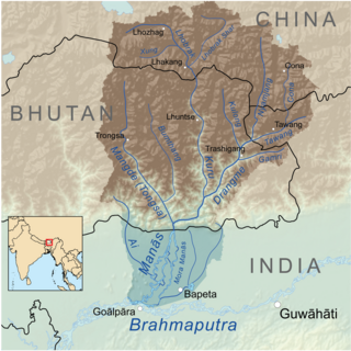
WKaljani River is a tributary of Torsha river, originated in Bhutan at the foothills of the Himalayas and it flows from north to south via Bhutan & India and confluences with Torsha river that again confluences with Brahmaputra river which confluences with Padma river that merges with Bay of Bengal. Kaljani river and its tributaries are attractions of the Dooars[] Major tributaries of Kaljani are Dima, Nonai, etc. The major portion of the river flows through the Indian state West Bengal. In 1993, towns like Alipurduar, Hamiltanganj on its bank was flooded when retaining wall of dam leaked and thrashed while letting the river enter in town killing hundreds of people and animals.
 W
WThe Kuri Chhu, also known as the Lhozhag Xung Qu or Norbu Lag Qu, is a major river of eastern Bhutan, that has formed a scenic valley with high peaks and steep hills. Kuri Chhu is a tributary of the Manas River system, which is the largest river of Bhutan and a major tributary of the Brahmaputra River that drains most of eastern Bhutan.
 W
WThe Manas River is a transboundary river in the Himalayan foothills between southern Bhutan and India. It is named after Manasa, the serpent god in Hindu mythology. It is the largest river system of Bhutan, among its four major river systems; the other three are Amo Chu or Torsa river, Wong Chu or Raidak, Puna Tshang Chu or Sankosh. It is met by three other major streams before it again debouches into India in western Assam. The total length of the river is 400 kilometres (250 mi), flows through Tibet, China for 24 km (15 mi), flows in Bhutan for 272 kilometres (169 mi) and then flows through Assam for 104 kilometres (65 mi) before it joins the mighty Brahmaputra River at Jogighopa. Another major tributary of the Manas, the Aie River joins it in Assam at Bangpari.
WMangde Chhu or Tongsa river flows in central Bhutan traversing roughly north-south. The river rises in Wangdue Phodrang district, near Gangkhar Puensum, Bhutan's highest peak at 7,546 metres (24,757 ft). Bhutan's main east-west highway crosses the Mangde Chhu about 8 kilometres (5 mi) west of Trongsa. South of Trongsa, the river drains the eastern slopes of the Black Mountains (Bhutan), and forms the eastern boundaries of Black Mountain National Park and Royal Manas National Park. Another highway follows the river south from Trongsa to Shemgang. The highway leaves the river at Tingtinbi, and eventually reaches the Indian border at Gelegphug. South of Tingtinbi, the Mangde is joined by the Bumthang River from the east, and is known as the Tongasa. Shortly before entering India in Assam, the Manas River flows into the river from the east, and the river exits Bhutan near Manas.
 W
WMo Chhu is a major river in Bhutan. The word "Chhu" means "river" or "water" in Dzongkha, the official national language in Bhutan. The river rises in Gasa Dzongkhag (district) near the border between Bhutan and Tibet. From there, the Mo Chhu flows generally southward to Punakha in central Bhutan, where it joins the Pho Chhu from the northeast. The confluence of the two streams is immediately below the Punakha Dzong, which is the winter home of the Dratshang Lhentshog and the Je Khenpo. The combined streams are then joined by the Dang Chhu near the town of Wangdue Phodrang, and the name of the river becomes the Puna Tsang Chhu. The river then flows through Dagana and Tsirang Districts. After leaving Bhutan near the town of Kalikhola, the river enters Assam in India and is known as the Sankosh. The Sankosh ultimately empties into the Brahmaputra.
WThe Paro Chhu is a river of western Bhutan. It is a tributary of the Wong Chhu, which is known as the Raidak in its lower reaches.
WPho Chhu is one of the major rivers of Bhutan, which tracks its source in the Gasa District that borders Bhutan with Tibet, which joins with Mo Chhu at the confluence below Punakha Dzong, the winter resident of Dratshang Lhentshog. Upon Dang Chhu joining below Wangdue Dzong, the trio flows as Puna Tsang Chhu and finally empties in the Brahmaputra, upon being joined by several tributaries on its course in the valley of Assam. Its source is susceptible to glaciers which even destroyed a part of Punakha Dzong.
 W
WThe Raidāk River, also called Wang Chhu or Wong Chhu in Bhutan, is a tributary of the River Brahmaputra, and a trans-boundary river. It flows through Bhutan, India and Bangladesh.
 W
WSankosh is a river that rises in northern Bhutan and empties into the Brahmaputra in the state of Assam in India. In Bhutan, it is known as the Puna Tsang Chu below the confluences of several tributaries near the town of Wangdue Phodrang. The two largest tributaries are the Mo Chhu and Pho Chhu, which flow together at Punakha. The Punakha dzong, which is situated immediately above the confluence of the two rivers, is one of the most beautiful dzongs in Bhutan and the winter residence of the Dratshang Lhentshog. The upper reaches of the Pho Chhu are susceptible to ice blockages, and the dzong has been damaged on several occasions by glacial lake outburst floods. After it enters in India, it flows on the border of Assam and West Bengal. At Wangdue Phodrang, elevation 1,364 metres (4,475 ft), the river is joined by the west flowing Tang Chuu and it enters a precipitous gorge. The highway running south from Wangdue Phodrang to Dagana follows the river for much of its course. Near the town of Takshay is the confluence with the west flowing Hara Chhu. The last major Bhutanese tributary is the Daga Chhu.
 W
WTawang Chu is one of the two main rivers of the Tawang district of Arunachal Pradesh in India. The other major river Nyamjang Chu joins it just before Tawang Chu enteres Bhutan. In Bhutan the river merges with various other rivers to emerge as the Manas River in the Indian plains to the south.
 W
WTorsa River rises from the Chumbi Valley in Tibet, China, where it is known as Machu. It flows into Bhutan, where it is known as the Amo Chu. It has total length of 358 kilometres (222 mi), out of which 113 kilometres (70 mi) is in China and 145 kilometres (90 mi) in Bhutan before flowing into the northern part of West Bengal in India.