 W
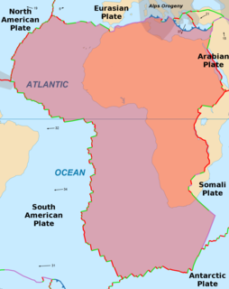
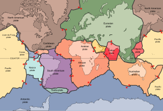
WThe African Plate is a major tectonic plate straddling the Equator as well as the prime meridian. It includes much of the continent of Africa, as well as oceanic crust which lies between the continent and various surrounding ocean ridges. Between 60 million years ago and 10 million years ago, the Somali Plate began rifting from the African Plate along the East African Rift. Since the continent of Africa consists of crust from both the African and the Somali plates, some literature refers to the African Plate as the Nubian Plate to distinguish it from the continent as a whole.
 W
WThe Antarctic Plate is a tectonic plate containing the continent of Antarctica, the Kerguelen Plateau and extending outward under the surrounding oceans. After breakup from Gondwana, the Antarctic plate began moving the continent of Antarctica south to its present isolated location causing the continent to develop a much colder climate. The Antarctic Plate is bounded almost entirely by extensional mid-ocean ridge systems. The adjoining plates are the Nazca Plate, the South American Plate, the African Plate, the Somali Plate, the Indo-Australian Plate, the Pacific Plate, and, across a transform boundary, the Scotia Plate.
 W
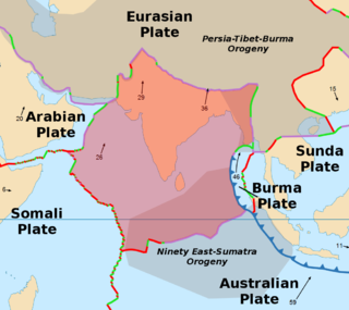
WThe Arabian Plate is a minor tectonic plate in the northern and eastern hemispheres.
 W
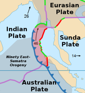
WThe Burma Plate is a minor tectonic plate or microplate located in Southeast Asia, sometimes considered a part of the larger Eurasian Plate. The Andaman Islands, Nicobar Islands, and northwestern Sumatra are located on the plate. This island arc separates the Andaman Sea from the main Indian Ocean to the west.
 W
WThe Capricorn Plate is a proposed minor tectonic plate lying beneath the Indian Ocean basin in the southern and eastern hemispheres. The original theory of plate tectonics as accepted by the scientific community in the 1960s assumed fully rigid plates and relatively narrow, distinct plate boundaries. However, research in the late 20th and early 21st centuries suggests that certain plate junctions are diffuse across several dozen or even hundred kilometres. The Capricorn Plate is a relatively rigid piece of oceanic crust along the far western edge of the former Indo-Australian Plate. The Capricorn Plate was once joined with the Indian Plate and the Australian Plate to form the Indo-Australian Plate, but recent studies suggest that the Capricorn Plate began separating from the Indian and Australian Plates between 18 million years ago and 8 million years ago along a wide, diffuse boundary.
 W
WThe Indian Plate or India Plate is a minor tectonic plate straddling the Equator in the Eastern Hemisphere. Originally a part of the ancient continent of Gondwana, India broke away from the other fragments of Gondwana 100 million years ago and began moving north. Once fused with the adjacent Australia to form a single Indo-Australian Plate, recent studies suggest that India and Australia have been separate plates for at least 3 million years and likely longer. The Indian Plate includes most of South Asia—i.e. the Indian subcontinent—and a portion of the basin under the Indian Ocean, including parts of South China and western Indonesia, and extending up to but not including Ladakh, Kohistan and Balochistan.
 W
WThe offshore Indus Basin is one of the two basins in offshore Pakistan, the other one being the offshore Makran Basin. The Murray Ridge separates the two basins. The offshore Indus basin is approximately 120 to 140 kilometers wide and has an areal extent of ~20,000 square km.
 W
WThe Owen Fracture Zone (OFZ), though misnamed a fracture zone, is a transform fault in the northwest Indian Ocean that separates the Arabian and African Plates from the Indian Plate. Extending north-northeast from where the Carlsberg Ridge meets the Sheba ridge in the south to the Makran Subduction Zone in the north, it represents the port side of the northward motion of the Indian subcontinent during the Late Cretaceous–Palaeogene break-up of Gondwana. Slip along the Owen Fracture Zone is occurring at 2 mm (0.079 in)/yr, the slowest rate on Earth, which means the Arabian Plate moves northward faster than the Indian Plate.
 W
WThe Australian Plate is a major tectonic plate in the eastern and, largely, southern hemispheres. Originally a part of the ancient continent of Gondwana, Australia remained connected to India and Antarctica until approximately 100 million years ago when India broke away and began moving north. Australia and Antarctica began rifting 85 million years ago and completely separated roughly 45 million years ago. The Australian plate later fused with the adjacent Indian Plate beneath the Indian Ocean to form a single Indo-Australian Plate. However, recent studies suggest that the two plates have once again split apart and have been separate plates for at least 3 million years and likely longer. The Australian Plate includes the continent of Australia, including Tasmania, as well portions of New Guinea, New Zealand, and the Indian Ocean basin.
 W
WThe Indo-Australian Plate is a major tectonic plate that includes the continent of Australia and surrounding ocean, and extends northwest to include the Indian subcontinent and adjacent waters. It was formed by the fusion of Indian and Australian plates approximately 43 million years ago. The fusion happened when the mid-ocean ridge in the Indian Ocean, which separated the two plates, ceased spreading.
 W
WThe Shiva Crater is a geologic structure, which is hypothesized by Sankar Chatterjee and colleagues to be a 500-kilometre (310 mi) diameter impact structure. This geologic structure consists of the Bombay High and Surat Depression. They lie beneath the Indian continental shelf and the Arabian Sea west of Mumbai, India. Chatterjee named this structure after Shiva, the Hindu god of destruction and renewal. It is presently (2019) on the list of probable impact craters and is rated '1' based on three-step confidence level criteria of Anna Mikheeva of Russian Academy of Sciences, applied to the impact sites that have appeared several times in the literature and/or have been endorsed by the Impact Field Studies Group (IFSG) and/or Expert Database on Earth Impact Structures (EDEIS).
 W
WThe Somali Plate is a minor tectonic plate which straddles the Equator in the Eastern Hemisphere. It is approximately centered on the island of Madagascar and includes about half of the east coast of Africa, from the Gulf of Aden in the north through the East African Rift Valley. The southern boundary with the Nubian-African Plate is a diffuse plate boundary consisting of the Lwandle Plate.
 W
WThe Sunda Plate is a minor tectonic plate straddling the Equator in the Eastern Hemisphere on which the majority of Southeast Asia is located.