 W
WAnza-Borrego Desert State Park (ABDSP) is a California State Park located within the Colorado Desert of southern California, United States. The park takes its name from 18th century Spanish explorer Juan Bautista de Anza and borrego, a Spanish word for sheep. With 585,930 acres (237,120 ha) that includes one-fifth of San Diego County, it is the largest state park in California.
 W
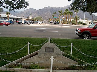
WBorrego Springs is a census-designated place (CDP) in San Diego County, California. The population was 3,429 at the 2010 census, up from 2,535 at the 2000 census, made up of both seasonal and year-round residents. Borrego Springs is completely surrounded by Anza-Borrego State Park, the largest California State Park.
 W
WCalifornia's 71st State Assembly district is one of 80 California State Assembly districts. It is currently represented by Republican Randy Voepel of Santee.
 W
WThe Carrizo Badlands are a landform of badlands that lie within Anza-Borrego Desert State Park in eastern San Diego County, and in the Carrizo Impact Area in western Imperial County, in southern California.
 W
WCoyote Mountain is a mountain of the Santa Rosa Mountains range, in eastern San Diego County, California.
 W
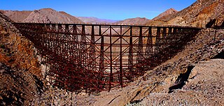
WGoat Canyon is a valley in San Diego County, California, United States, located within the Carrizo Gorge in the Jacumba Mountains. The rock forming the canyon is crystalline basement. One feature of the canyon is a dry waterfall. The canyon is bridged by a wooden railroad trestle, the Goat Canyon Trestle, which is the world's largest curved all-wood trestle. The canyon is accessible by trail by traveling west from Mortero Palms.
 W
WThe Grapevine Hills are a low mountain range within Anza-Borrego Desert State Park in the Colorado Desert, in eastern San Diego County, southern California.
 W
WThe Mud Caves are a popular feature in Anza Borrego Desert State Park in San Diego County, California. The caves, located in the Carrizo Badlands, along the Arroyo Tapiado, were created by water flowing through a thick deposit of silt and are an example of pseudokarst topography. There are at least 22 caves, some up to 1,000 feet (300 m) in length and 80 feet (24 m) in height. Many of the caves are easily accessed.
WThe Pinyon Mountains are a mountain range in eastern San Diego County, Southern California. The range is protected within Anza Borrego Desert State Park.
WThe San Felipe Hills are a low mountain range in eastern San Diego County, southern California.
 W
WThe Santa Rosa Mountains are a short mountain range in the Peninsular Ranges system, located east of the Los Angeles Basin and northeast of the San Diego metropolitan area of southern California, in the southwestern United States.
 W
WShelter Valley is a community in San Diego County in the U.S. state of California. The town is located along County Route S2, two miles south of its intersection with State Route 78 and 12 miles east of Julian. It lies within the boundaries of the Anza-Borrego Desert State Park and the geologic feature known as Earthquake Valley. The Pacific Crest Trail passes along the northern boundary of the community.
 W
WThe Vallecito Mountains are located in the Colorado Desert, in eastern San Diego County, Southern California. They are about 28 miles (45 km) north of the U.S. border with Mexico.