 W
WThe Wabash River is a 503-mile-long (810 km) river that drains most of the state of Indiana in the United States. It flows from the headwaters in Ohio, near the Indiana border, then southwest across northern Indiana turning south near the Illinois border where the southern portion forms the Indiana-Illinois border before flowing into the Ohio River. It is the largest northern tributary of the Ohio River and third largest overall, right behind the Cumberland and Tennessee Rivers. From the dam near Huntington, Indiana, to its terminus at the Ohio River, the Wabash flows freely for 411 miles (661 km). Its watershed drains most of Indiana. The Tippecanoe River, White River, Embarras River and Little Wabash River are major tributaries. The river's name comes from a Miami Indian word meaning "water over white stones".
 W
WThe Bieker-Wilson Village Site is an archaeological site in the far southeastern section of the U.S. state of Illinois. Inhabited during multiple periods over more than five hundred years, the village has been designated a historic site.
 W
WThe Duffy Site is a substantial archaeological site along the Wabash River in the southeastern part of the U.S. state of Illinois. Located near the village of New Haven in Gallatin County, it is the type site for the Duffy Complex, a group of similar sites on the Illinois side of the Wabash near its confluence with the Ohio River. Duffy is distinctive largely because of its pottery: the site's inhabitants typically produced ceramics of various thicknesses and comparatively few decorative elements, tempered with grog. What decorations exist are typically limited to one or two rows of simple lines or bars that have been incised or stamped on the side of the piece of pottery. Projectile points found at the site are small triangular "Mounds Stemless" points, and the inhabitants produced celts of a vaguely rectangular shape. The site is believed to have been inhabited circa AD 1000.
 W
WThe Grand Rapids Dam was a dam located on the Wabash River on the state line between Wabash County and Knox County in the U.S. states of Illinois and Indiana. The dam was built in the late 1890s by the Army Corps of Engineers to improve navigation on the Wabash River. The dam was located near Mount Carmel, Illinois.
 W
WHanging Rock is a natural sandstone rock formation overhanging the Wabash River in Wabash County, Illinois, in the United States. The rock formation is north of the town of Mount Carmel, Illinois, and located on land originally purchased by Thomas S. Hinde. The formation was formed while the glaciers melted and carved the landscapes of North America. The Native Americans were the first group of people to settle around Hanging Rock. Later the Hinde family purchased the property and used it for tourism and business.
 W
WThomas Spottswood Hinde was an American newspaper editor, opponent of slavery, author, historian, real estate investor, Methodist minister and a founder of the city of Mount Carmel, Illinois. Members of the Hinde family were prominent in Virginia, Kentucky, Ohio, and Illinois. His sons Charles T. Hinde became a shipping magnate and Edmund C. Hinde an adventurer. He was the father-in-law of judge Charles H. Constable.
 W
WThe Hubele Mounds and Village Site are an archaeological site in the southeastern part of the U.S. state of Illinois. Located near the community of Maunie in White County, the site has received recognition from the federal government because of its archaeological value. Due to the lack of recent excavations, the site's dates of habitation are debated, ranging from 400 BC in some estimates to AD 1000 in others, but all agree on the site's significance to understanding the prehistory of the region.
 W
WThe Hutsonville Bridge or Sullivan-Hutsonville Bridge connecting Crawford County, Illinois, and Sullivan County, Indiana, over the Wabash River, built 1939 and replaced in 1988, was an example of the relatively rare self-anchored suspension bridge type. It was designed by Robinson & Steinman, with R. V. Milbank as the resident chief engineer, and constructed by Wisconsin Bridge and Iron Company as general contractor and Vincennes Steel Corporation as steel fabricators and Charles J. Glasgow as a subcontractor.
 W
WLincoln Memorial Bridge is a deck arch bridge carrying U.S. Route 50 Business over the Wabash River between Vincennes, Indiana and Lawrence County, Illinois. It is said to mark the point where Abraham Lincoln crossed the Wabash River on his way to Illinois in 1830, and a sculptural installation, the Lincoln Trail State Memorial, marks the western end of the bridge.
 W
WThe New Harmony Toll Bridge, also known as the Harmony Way Bridge, is a now-closed two-lane bridge across the Wabash River that connects Illinois Route 14 with Indiana State Road 66, which is Church Street in New Harmony, Indiana. The bridge links White County, Illinois with Posey County, Indiana and carried U.S. Route 460 from 1947 until 1974 when the highway was decommissioned in Illinois and Indiana. The four-span bridge is owned by the White County Bridge Commission and was built without federal funds in 1930 by the Big Wabash Bridge Company of Carmi, Illinois. The next bridge across the Wabash about 15 miles (24 km) downstream is the Wabash Memorial Bridge near Mount Vernon, Indiana and the next bridge upstream is for Interstate 64, which does not allow farm vehicles.
 W
WParadise Spring Treaty Grounds and Historical Park is located on the corner of Allen and Market streets in Wabash, Indiana. Erected 1992 Indiana Historical Bureau and Wabash County Tourism.
 W
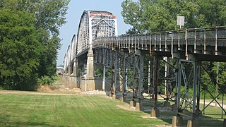
WThe Wabash Memorial Bridge carries vehicular traffic across the Wabash River between Indiana State Road 62 and Illinois Route 141. The 4,932-foot-long (1,503 m), two-lane bridge is located in both Posey County, Indiana, and White County, Illinois. The bridge is operated by the Indiana Department of Transportation (INDOT). The bridge was built in 1956 and has an estimated life of 75 years. It is the southernmost span connecting Illinois and Indiana, with the next bridge to the north located in New Harmony, Indiana.