 W
WThe River Cart is a tributary of the River Clyde, Scotland, which it joins from the west roughly midway between the towns of Erskine and Renfrew and opposite the town of Clydebank.
 W
WBodinbo Island is an islet in the estuarine waters of the River Clyde close to the old ferry slipway at Erskine. Before the dyke or training wall was built the rocky Bodinbo Island was a prominent feature in the river hereabouts and a hazard to shipping, especially sailing craft in the dark, during foggy weather, flood conditions and in high winds. On Ordnance Survey maps the name has been transliterated to Bottombow Island and Boden Boo is the spelling variant used for the nearby woodland plantation.
 W
WKing's Inch and the much smaller Sand Inch were islands lying in the estuarine waters of the River Clyde close to Renfrew in Renfrewshire, Scotland. Due to dredging and a change of the course of the main current of the River Clyde, silting, etc. it has become part of the southern, Renfrewshire side, of the river bank and is now built over.
 W
WMilton Island or Green Inch was an island in the Clyde's estuarine waters close to the old ford across the river at Dumbuck near Dumbarton. The island was once part of the tidal ford supposedly built by the Romans. Industrial activity has changed the river currents and the island has become substantially reduced in size and split into islets.
 W
WNewshot Island or Newshot Isle was an island of circa 50 acres or 20 hectares lying in the estuarine waters of the River Clyde close to Park Quay in the Parish of Inchinnan, Renfrewshire, Scotland. Due to silting, etc. it has become part of the southern, Renfrewshire side, of the river bank and is used for grazing cattle and as a nature reserve.
 W
WThe disused Park Quay or Fulton's Quay is located on the old Lands of Park, situated on the south bank of the River Clyde in the Parish of Inchinnan, close to Newshot Island and the old Rashielee Quay. A slipway is also part of the infrastructure, giving access to the dock at low tide, both once served by roads running through the Park Estate from the south. It was recorded as Fulton's Quay in 1830, the name of a previous owner of the Park Estate who may have built it prior to 1801. A fixed light was installed at Park Quay in 1869.
 W
WThe old Rashielee Quay or Rashielie Quay (NS471709) was located on the old Lands of North Barr, situated on the south bank of the River Clyde in the Parish of Inchinnan, between Bodinbo Island and Park Quay. It was built to facilitate the loading of boats and barges with whinstone excavated from the nearby Rashielee Quarries that was brought to the quay by a horse drawn wagonway.
 W
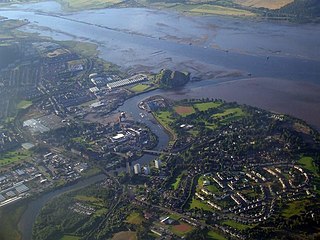
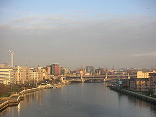
WThe River Clyde is a river that flows into the Firth of Clyde in Scotland. It is the eighth-longest river in the United Kingdom, and the second-longest in Scotland. Traveling through the major city of Glasgow, it was an important river for shipbuilding and trade in the British Empire. To the Romans, it was Clota, and in the early medieval Cumbric language, it was known as Clud or Clut, and was central to the Kingdom of Strathclyde.
 W
WWhite Inch was an island lying in the estuarine waters of the River Clyde close to Glasgow in the Parish of Govan, Lanarkshire, Scotland. Due to the deliberate disposal of dredged material from the Clyde it became physically part of the northern, Lanarkshire side, of the river bank from the 1830s and is now entirely built over. The name lives on in the Whiteinch district of Glasgow, street names, etc. and probably relates to white coloured sand deposits.
 W
WThe River Kelvin is a tributary of the River Clyde in northern and northeastern Glasgow, Scotland. It rises on the moor south east of the village of Banton, east of Kilsyth. At almost 22 miles (35 km) long, it initially flows south to Dullatur Bog where it falls into a man made trench and takes a ninety degree turn flowing west through Strathkelvin and along the northern boundary of the bog parallel with the Forth and Clyde Canal.
 W
WThe Levern Water, is a small river in East Renfrewshire and Glasgow, Scotland. It rises in the Long Loch, and flows generally north and east, past the towns of Neilston and Barrhead, for a total distance of 9 miles (14 km). It empties into the White Cart River.
 W
WThe Molendinar Burn is a burn in Glasgow, Scotland. It was the site of the settlement, Mellingdenor, that grew to become the kernel of Glasgow, and where St Mungo founded his church in the 6th century. It was later used to power the growing town's mills and the name became adapted because the word "molendinar" means "relating to a mill or millers".