 W
WPontiac's War, also known as Pontiac's Conspiracy or Pontiac's Rebellion, was launched in 1763 by a loose confederation of American Indian tribes, primarily from the Great Lakes region, the Illinois Country, and Ohio Country who were dissatisfied with British policies in the Great Lakes region following the French and Indian War (1754–1763). Warriors from numerous tribes joined the uprising in an effort to drive British soldiers and settlers out of the region. The war is named after Odawa leader Pontiac, the most prominent of many Indian leaders in the conflict.
 W
WBushy Run Battlefield Park is a historical park that is operated by the Pennsylvania Historical and Museum Commission (PHMC) and the Bushy Run Battlefield Heritage Society on 218 acres (88 ha) in Penn Township, Westmoreland County, Pennsylvania in the United States. It was the site of the Battle of Bushy Run fought on August 5–6, 1763 during the Pontiac's Rebellion. The battle was a major victory for the British and enabled them to secure their control of the Ohio River Valley and what was to become the Northwest Territory. Bushy Run Battlefield Park was established as a Pennsylvania State Park in the 1920s and became a National Historic Landmark in 1960. The Visitor Center is open Wednesday through Saturday from 9:00 am until 5:00 pm, and Sunday from noon to 5:00 pm, during the months of May–October. The Visitor Center hosts a museum exhibit entitled, "The March to Bushy Run", a theater, a gift shop and battlefield tours. Bushy Run Battlefield Park is the only historic site or museum that deals exclusively with Pontiac's Rebellion. Battle reenactments are held annually on the first full weekend of August. The park is on Pennsylvania Route 993 near Harrison City and Jeannette.
 W
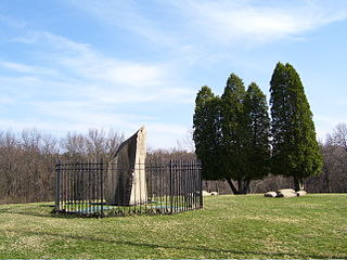
WOn July 26, 1764, four Delaware (Lenape) Native Americans entered a settlers' log schoolhouse in the Province of Pennsylvania and killed the schoolmaster, Enoch Brown, and nine students, wounded two other students and kidnapped four others. Historian Richard Middleton described the massacre as "one of the most notorious incidents" of Pontiac's War.
 W
WFort Loudoun was a fort in colonial Pennsylvania, one of several forts in colonial America named after John Campbell, 4th Earl of Loudoun. The fort was built in 1756 during the French and Indian War by the Second Battalion of the Pennsylvania Regiment under Colonel John Armstrong, and served as a post on the Forbes Road during the Forbes expedition that successfully drove the French away from Fort Duquesne.
 W
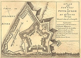
WFort Pitt was a fort built by British forces between 1759 and 1761 during the French and Indian War at the confluence of the Monongahela and Allegheny rivers, where the Ohio River is formed in western Pennsylvania. It was near the site of Fort Duquesne, a French colonial fort built in 1754 as tensions increased between Great Britain and France in both Europe and North America. The French destroyed Fort Duquesne in 1758 when they retreated under British attack.
 W
WFort Presque Isle was a fort built by French soldiers in summer 1753 along Presque Isle Bay at present-day Erie, Pennsylvania, to protect the northern terminus of the Venango Path. It was the first of the French posts built in the Ohio Country, and was part of a line that included Fort Le Boeuf, Fort Machault, and Fort Duquesne.
 W
WFort Saint Joseph was a fort established on land granted to the Jesuits by King Louis XIV; it was located on what is now the south side of the present-day town of Niles, Michigan. Père Claude-Jean Allouez established the Mission de Saint-Joseph in the 1680s. Allouez ministered to the local Native Americans, who were primarily Odawa and Ojibwe.
WFort Venango, a small British fort built in 1760 near the site of Franklin, Pennsylvania, replaced Fort Machault, a French fort burned by the French in 1759 near the end of the French and Indian War. About June 16, 1763, during Pontiac's War, the fort was captured by Seneca and Mingo warriors. The 12 to 16 soldiers of the fort were killed outright, except for the commander, Lieutenant Francis Gordon, who was forced to write a letter detailing why the Indians had risen against the British. He transcribed two complaints: the scarcity of gunpowder for the past two years and the fact that the English, contrary to their promises, were keeping forts, and building new forts, in Indian territory. He was then slowly tortured and roasted to death at the stake, and the fort was burnt to the ground.
 W
WFort Le Boeuf was a fort established by the French during 1753 on a fork of French Creek, in present-day Waterford, in northwest Pennsylvania. The fort was part of a line that included Fort Presque Isle, Fort Machault, and Fort Duquesne.
 W
WPaul Muldoon's poem Meeting the British, first published in the 1987 collection of the same name, is an account of the Pontiac's Rebellion of 1763 in the aftermath of the French and Indian War, written from an the perspective of a Native American.
 W
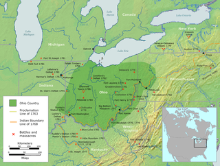
WThe Ohio Country was a name used in the mid- to late 18th century for a region of North America west of the Appalachian Mountains and north of the upper Ohio and Allegheny Rivers extending to Lake Erie. The area encompassed roughly all of present-day states of Ohio, northwestern West Virginia, Western Pennsylvania, and a wedge of southeastern Indiana.
 W
WThe Royal Proclamation of 1763 was issued by King George III on October 7, 1763. It followed the Treaty of Paris (1763), which formally ended the Seven Years' War and transferred French territory in North America to Great Britain. The Proclamation forbade all settlement west of a line drawn along the Appalachian Mountains, which was delineated as an Indian Reserve. Exclusion from the vast region of Trans-Appalachia created discontent between Britain and colonial land speculators and potential settlers. The proclamation and access to western lands was one of the first significant areas of dispute between Britain and the colonies and would become a contributing factor leading to the American Revolution. The 1763 proclamation line is similar to the Eastern Continental Divide's path running northwards from Georgia to the Pennsylvania–New York border and north-eastwards past the drainage divide on the St. Lawrence Divide from there northwards through New England.