 W
WThe Batagaika crater is a thermokarst depression in the Chersky Range area. The biggest permafrost crater in the world, it administratively belongs to the Sakha Republic, Russia.
 W
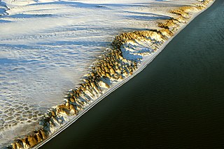
WBaydzharakh, a term based in the Yakut language, is a roughly cone-shaped natural rock formation. They are usually composed of siltstone, silty peat or loam.
 W
WA frost boil, also known as mud boils, a stony earth circles, frost scars, or mud circles, are small circular mounds of fresh soil material formed by frost action and cryoturbation. They are found typically found in periglacial or alpine environments where permafrost is present, and may damage roads and other man-made structures. They are typically 1 to 3 metres in diameter.
 W
WAn ice wedge is a crack in the ground formed by a narrow or thin piece of ice that measures up to 3–4 meters in length at ground level and extends downwards into the ground up to several meters. During the winter months, the water in the ground freezes and expands. Once temperatures reach −17 degrees Celsius or lower, the ice that has already formed acts like a solid and expands to form cracks in the surface known as ice wedges. As this process continues over many years ice wedges can grow, up to the size of a swimming pool. Ice wedges usually appear in a polygonal pattern known as ice wedge polygons. The cracks can also be filled with materials other than ice, especially sand, and are then called sand wedges.
 W
WPalsas are peat mounds with a permanently frozen peat and mineral soil core. They are a typical phenomenon in the polar and subpolar zone of discontinuous permafrost. One of their characteristics is having steep slopes that rises above the mire surface. This leads to the accumulation of large amounts of snow around them. The summits of the palsas are free of snow even in winter, because the wind carries the snow and deposits on the slopes and elsewhere on the flat mire surface. Palsas can be up to 150 m in diameter and can reach a height of 12 m.
 W
WPatterned ground is the distinct and often symmetrical natural pattern of geometric shapes formed by the deformation of ground material in periglacial regions. It is typically found in remote regions of the Arctic, Antarctica, and the Outback in Australia, but is also found anywhere that freezing and thawing of soil alternate; patterned ground has also been observed in the hyper-arid Atacama Desert and on Mars. The geometric shapes and patterns associated with patterned ground are often mistaken as artistic human creations. The mechanism of the formation of patterned ground had long puzzled scientists but the introduction of computer-generated geological models in the past 20 years has allowed scientists to relate it to frost heaving, the expansion that occurs when wet, fine-grained, and porous soils freeze.
 W
WPingos are intrapermafrost ice-cored hills, ranging in height from 3 to 70 m and 30 to 1,000 m in diameter. They are typically conical in shape and grow and persist only in permafrost environments, such as the Arctic and subarctic. A pingo is a periglacial landform, which is defined as a non-glacial landform or process linked to colder climates. It is estimated that there are more than 11,000 pingos on Earth. The Tuktoyaktuk peninsula area has the greatest concentration of pingos in the world with a total of 1,350 pingos. There are currently remarkably limited data on pingos.
 W
WSolifluction is a collective name for gradual processes in which a mass moves down a slope related to freeze-thaw activity. This is the standard modern meaning of solifluction, which differs from the original meaning given to it by Johan Gunnar Andersson in 1906.
 W
WA stone run is a rock landform resulting from the erosion of particular rock varieties caused by freezing-thawing cycles in periglacial conditions during the last Ice Age.
 W
WWeddell Island is one of the Falkland Islands in the South Atlantic, lying off the southwest extremity of West Falkland. It is situated 1,545 km (960 mi) west-northwest of South Georgia Island, 1,165 km (724 mi) north of Livingston Island, 606 km (377 mi) northeast of Cape Horn, 358 km (222 mi) northeast of Isla de los Estados, and 510 km (320 mi) east of the Atlantic entrance to Magellan Strait.
 W
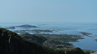
WStrandflat is a landform typical of the Norwegian coast consisting of a flattish erosion surface on the coast and near-coast seabed. In Norway, strandflats provide room for settlements and agriculture, constituting important cultural landscapes. The shallow and protected waters of strandflats are valued fishing grounds that provide sustenance to traditional fishing settlements. Outside Norway proper, strandflats can be found in other high-latitude areas, such as Antarctica, Alaska, the Canadian Arctic, the Russian Far North, Greenland, Svalbard, Sweden and Scotland.
 W
WThermokarst is a land surface characterised by very irregular surfaces of marshy hollows and small hummocks formed as ice-rich permafrost thaws, that occurs in Arctic areas, and on a smaller scale in mountainous areas such as the Himalayas and the Swiss Alps. These pitted surfaces resemble those formed by solution in some karst areas of limestone, which is how they came to have karst attached to their name without the presence of any limestone. Small domes that form on the surface due to frost heaving with the onset of winter are only temporary features. They then collapse with the arrival of next summer's thaw and leave a small surface depression. Some ice lenses grow and form larger surface hummocks, which last many years and sometimes become covered with grasses and sedges, until they begin to thaw. These domed surfaces eventually collapse either annually or after longer periods and form depressions which contribute to uneven surfaces. These are included within the general label of thermokarst.