 W
WDome A or Dome Argus is the loftiest ice dome on the Antarctic Plateau, located 1,200 kilometres (750 mi) inland. It is thought to be the coldest naturally occurring place on Earth; with temperatures believed to reach −90 °C (−130 °F) to −98 °C (−144 °F). It is the highest ice feature in Antarctica, consisting of an ice dome or eminence of 4,093 metres' (13,428 ft) elevation above sea level. It is located near the center of East Antarctica, approximately midway between the enormous head of Lambert Glacier and the geographic South Pole, within the Australian claim.
 W
WDome C, also known as Dome Circe, Dome Charlie or Dome Concordia, located at Antarctica at an elevation of 3,233 metres (10,607 ft) above sea level, is one of several summits or "domes" of the Antarctic Ice Sheet. Dome C is located on the Antarctic Plateau, 1,100 kilometres (680 mi) inland from the French research station at Dumont D'Urville, 1,100 kilometres (680 mi) inland from the Australian Casey Station and 1,200 kilometres (750 mi) inland from the Italian Zucchelli station at Terra Nova Bay. Russia's Vostok Station is 560 kilometres (350 mi) away. Dome C is the site of the Concordia Research Station, jointly operated by France and Italy.
WDome Fuji, also called Dome F or Valkyrie Dome, is an Antarctic base located in the eastern part of Queen Maud Land at 77°30′S 37°30′E. With an altitude of 3,810 m or 12,500 ft above sea level, it is the second-highest summit or ice dome of the East Antarctic ice sheet and represents an ice divide. Dome F is the site of Dome Fuji Station, a research station operated by Japan.
 W
WHurd Ice Cap is the ice cap covering the central area of southern Hurd Peninsula, Livingston Island in the South Shetland Islands, Antarctica. It extends 4.5 km in northeast-southwest direction and 3.7 km in northwest-southeast direction, and drains both into South Bay to the northwest and into False Bay to the southeast. Its summit point has been nicknamed named Dorotea by personnel of the nearby Spanish base Juan Carlos Primero and rises to 332 m.
 W
WKraków Dome is the ice dome covering Kraków Peninsula, King George Island, in the South Shetland Islands. The name Kopula Krakowa, after Kraków, the old capital of Poland, was applied to this feature by the Polish Antarctic Expedition, 1980.
 W
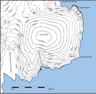
WLaw Dome is a large ice dome which rises to 1,395 metres (4,580 ft) directly south of Cape Poinsett, Antarctica. The feature was roughly mapped by the United States Geological Survey from aerial photographs taken by U.S. Navy Operation Highjump, 1946–47, and has been the subject of intensive glaciological and geophysical surveys by Australian National Antarctic Research Expeditions between 1962 and 1965. It was named by the Antarctic Names Committee of Australia for Phillip Law, Director of the Australian Antarctic Division from 1949 to 1966.
 W
WPerkos Dome (Bulgarian: купол Перкос, ‘Kupol Perkos’ \'ku-pol 'per-kos\ is the ice dome rising to 2050 m in the west part of Detroit Plateau on Danco Coast in Graham Land, Antarctica. It is situated between tributaries to Lilienthal, Sikorsky and Breguet Glaciers.
 W
WRotch Dome is the sloping ice dome rising to 360 m immediately east of Byers Peninsula, and between Barclay Bay and Walker Bay in Livingston Island, South Shetland Islands, Antarctica. It is bounded by Urvich Wall to the west, surmounting Ivanov Beach to the northwest, Etar Snowfield to the north-northeast and Verila Glacier to the east-northeast, and is linked by a saddle to Casanovas Peak to the northeast.
 W
WSiple Dome is an ice dome approximately 100 km wide and 100 km long, located 130 km east of Siple Coast in Antarctica. Charles Bentley and Robert Thomas established a "strain rosette" on this feature to determine ice movement in 1973-74. They referred to the feature as Siple Dome because of its proximity to Siple Coast.
WTalos Dome is a large ice dome rising to 2,300 m to the southwest of the Usarp Mountains in Antarctica. The dome overlies the east margin of the Wilkes Subglacial Basin. The feature was delineated by the Scott Polar Research Institute (SPRI)-National Science Foundation (NSF)-Technical University of Denmark (TUD) airborne radio echo sounding program, 1967–79, and was named after Talos of Greek mythology, who assisted Minos in the defense of Crete.
 W
WTinsel Dome is a small ice-covered hill, 700 m, standing between Aureole Hills and Bone Bay on Trinity Peninsula. Charted in 1948 by the Falkland Islands Dependencies Survey (FIDS) who gave this descriptive name.
 W
WTumba Ice Cap is the ice cap covering the western half of Chavdar Peninsula on the west side of Graham Land, Antarctic Peninsula. It is situated west of Samodiva Glacier, extending 7.7 km in east-west direction and 4 km in north-south direction, and draining both northwards into Curtiss Bay and southwards into Hughes Bay