 W
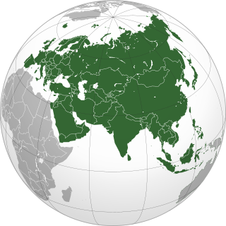
WAfro-Eurasia, nicknamed the World Island, is a landmass comprising the continents of Africa, Asia, and Europe. The terms are portmanteaus of the names of its constituent parts. Its mainland is the largest contiguous landmass on Earth, as well as the most populous.
 W
WThe cartography of Asia can refer to the representation of Asia on a map, or to depictions of the world by cartographers from Asia. Depictions of portions of Asia have existed on maps as early as the 6th century BCE, with maps being drafted to depict the Babylonian, Hellenistic Greek, and Han dynasty empires.
 W
WChinese Tartary is an archaic geographical term used especially during the time of the Qing Dynasty. The term was used as early as 1734 on a map created by the French geographer and cartographer Jean Baptiste Bourguignon d’Anville (1697–1782) who published the map in the Nouvel atlas de la Chine, de la Tartarie Chinoise et du Thibet in 1738.
 W
WThis is a list of the extreme points of Eurasia, the points that are farther north, south, east or west than any other location on the continent. Some of these locations are open to debate, owing to the diverse definitions of Europe and Asia.
 W
WThe location of the geographical centre of Asia depends on the definition of the borders of Asia, mainly whether remote islands are included to define the extreme points of Asia, and on the method of calculating the final result.
 W
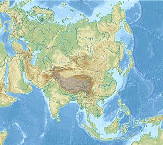
WGeography of Asia reviews geographical concepts of classifying Asia, the central and eastern part of Eurasia, comprising approximately fifty countries.
 W
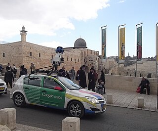
WIn Asia, Google Street View is available in Bangladesh, Bhutan, Cambodia, Hong Kong, Indonesia, Israel, Japan, Kyrgyzstan, Macau, Malaysia, Mongolia, Philippines, Russia, Singapore, South Korea, Sri Lanka, Taiwan, Thailand and Turkey. It is also available for a few select tourist attractions in the People's Republic of China and Pakistan.
 W
WThe Indian subcontinent, or, sometimes simply called the subcontinent, is a physiographical region in southern Asia, situated on the Indian Plate and projecting southwards into the Indian Ocean from the Himalayas. Geologically, the Indian subcontinent is related to the landmass that rifted from the supercontinent Gondwana during the Cretaceous and merged with the Eurasian landmass nearly 55 million years ago. Geographically, it is the peninsular region in south-central Asia, delineated by the Himalayas in the north, the Hindu Kush in the west, and the Arakanese in the east. Geopolitically, the Indian subcontinent generally includes all or part of Bangladesh, Bhutan, India, Nepal, Pakistan and Sri Lanka, as well as Maldives. Albeit rarely, some authors also include Afghanistan and Myanmar. The terms "Indian subcontinent" and "South Asia" are sometimes used interchangeably to denote the region.
 W
WThis page lists the highest natural elevation of each sovereign state on the continent of Asia defined physiographically. States sometimes associated with Asia politically and culturally, but not geographically part of Asia, are not included in this list of physical features.
 W
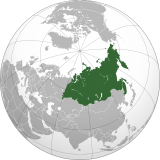
WNorth Asia or Northern Asia, also referred to as Siberia, is the northern region of Asia, which is defined in geographical terms. North Asia is solely administrated by Russia, and consists of the Russian regions east of the Ural Mountains: Ural, Siberia and the Russian Far East. North Asia is bordered by the Arctic Ocean to its north, by Eastern Europe to its west, by Central and East Asia to its south, and by the Pacific Ocean and North America to its east. The region covers an area of approximately 13,100,000 square kilometres (5,100,000 sq mi), or 8.8% of Earth's total land area. It is the largest subregion of Asia by area, but is also the least populated, with an approximate population of only 33 million people or only 0.74% of Asia's population.
 W
WThe Asia-Pacific is the part of the world in or near the Western Pacific Ocean. Asia-Pacific varies in area depending on context, but it generally includes East Asia, South Asia, Southeast Asia, and Oceania.
 W
WThe term Southeast Asian Massif was proposed in 1997 by anthropologist Jean Michaud to discuss the human societies inhabiting the lands above approximately 300 metres (1,000 ft) in the southeastern portion of the Asian landmass, thus not merely in the uplands of conventional Mainland Southeast Asia. It concerns highlands overlapping parts of 10 countries: southwest China, Northeast India, eastern Bangladesh, and all the highlands of Myanmar (Burma), Thailand, Vietnam, Laos, Cambodia, Peninsular Malaysia, and Taiwan. The indigenous population encompassed within these limits numbers approximately 100 million, not counting migrants from surrounding lowland majority groups who came to settle in the highlands over the last few centuries.