 W
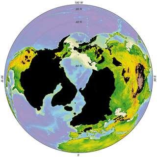
WThe Last Glacial Period (LGP) occurred from the end of the Eemian to the end of the Younger Dryas, encompassing the period c. 115,000 – c. 11,700 years ago. The LGP is part of a larger sequence of glacial and interglacial periods known as the Quaternary glaciation which started around 2,588,000 years ago and is ongoing. The definition of the Quaternary as beginning 2.58 million years ago is based on the formation of the Arctic ice cap. The Antarctic ice sheet began to form earlier, at about 34 Ma, in the mid-Cenozoic. The term Late Cenozoic Ice Age is used to include this early phase.
 W
WThe Champlain Sea was a temporary inlet of the Atlantic Ocean, created by the retreating glaciers during the close of the last glacial period. The Sea once included lands in what are now the Canadian provinces of Quebec and Ontario, as well as parts of the American states of New York and Vermont.
 W
WDansgaard–Oeschger events are rapid climate fluctuations that occurred 25 times during the last glacial period. Some scientists say that the events occur quasi-periodically with a recurrence time being a multiple of 1,470 years, but this is debated. The comparable climate cyclicity during the Holocene is referred to as Bond events.
 W
WThe early Holocene sea level rise (EHSLR) was a significant jump in sea level by about 60 m during the early Holocene, between about 12,000 and 7,000 years ago, spanning the Eurasian Mesolithic. The rapid rise in sea level and associated climate change, notably the 8.2 ka cooling event , and the loss of coastal land favoured by early farmers, may have contributed to the spread of the Neolithic to Europe.
 W
WThe Goldthwait Sea was a sea that emerged during the last deglaciation, starting around 13,000 years ago, covering what is now the Gulf of Saint Lawrence and surrounding areas. At that time, the land had been depressed under the weight of the Laurentide Ice Sheet, which was up to 2 kilometres (1.2 mi) thick. Areas on the Anticosti Island and low-lying regions of Quebec and the Maritimes bordering the Saint Lawrence were below sea level. As the land rebounded over the next 3,000 years, despite rising sea levels the sea retreated to roughly the present boundaries of the Gulf.
 W
WThe last glacial period and its associated glaciation is known in southern Chile as the Llanquihue glaciation. Its type area lies west of Llanquihue Lake where various drifts or end moraine systems belonging to the last glacial period have been identified. The glaciation is the last episode of existence of the Patagonian Ice Sheet.
 W
WThe Oldest Dryas is a biostratigraphic subdivision layer corresponding to an abrupt cooling event, or stadial, which occurred during the last glacial retreat. The time period to which the layer corresponds varies between regions, but it is generally dated as starting at 18.5-17 ka BP and ending 15-14 ka BP. As with the Younger and Older Dryas events, the stratigraphic layer is marked by abundance of the pollen and other remains of Dryas octopetala, an indicator species that colonizes arctic-alpine regions.
 W
WLake Vermont, also called Glacial Lake Vermont, was a temporary lake created by the retreating glaciers during the close of the last ice age. The lake once included land in the Canadian province of Quebec and the American states Vermont and New York. It was a geographical predecessor of Lake Champlain. Once the glacier retreated far enough north, it drained into Glacial Lake Candona, the geologic predecessor of the St. Lawrence River.
 W
WWeichselian glaciation refers to the last glacial period and its associated glaciation in northern parts of Europe. In the Alpine region it corresponds to the Würm glaciation. It was characterized by a large ice sheet that spread out from the Scandinavian Mountains and extended as far as the east coast of Schleswig-Holstein, the March of Brandenburg and Northwest Russia.
 W
WThe Wisconsin Glacial Episode, also called the Wisconsin glaciation, was the most recent glacial period of the North American ice sheet complex. This advance included the Cordilleran Ice Sheet, which nucleated in the northern North American Cordillera; the Innuitian ice sheet, which extended across the Canadian Arctic Archipelago; the Greenland ice sheet; and the massive Laurentide Ice Sheet, which covered the high latitudes of central and eastern North America. This advance was synchronous with global glaciation during the last glacial period, including the North American alpine glacier advance, known as the Pinedale glaciation. The Wisconsin glaciation extended from approximately 75,000 to 11,000 years ago, between the Sangamonian Stage and the current interglacial, the Holocene. The maximum ice extent occurred approximately 25,000–21,000 years ago during the last glacial maximum, also known as the Late Wisconsin in North America.
 W
WThe Würm glaciation or Würm stage, in the literature usually just referred to as the Würm, often spelt "Wurm", was the last glacial period in the Alpine region. It is the youngest of the major glaciations of the region that extended beyond the Alps themselves. It is, like most of the other ice ages of the Pleistocene epoch, named after a river, the Würm in Bavaria, a tributary of the Amper. The Würm ice age can be dated to the time about 115,000 to 11,700 years ago, the sources differing depending on whether the long transition phases between the glacials and interglacials are allocated to one or other of these periods. The average annual temperatures during the Würm ice age in the Alpine Foreland were below −3 °C. This has been determined from changes in the vegetation as well as differences in the facies.